TopoQuest Logo
Do you find TopoQuest useful?
Help keep TopoQuest running and adding new maps/features by donating!
Bitcoin:  19c7KJd3qBynnjoSw5npx9KScwjBe4ifkT
Litecoin:  LXs6TkuXGGXo1vDsWCkWVdjQX94eUKd6ui
Home View Maps Find Maps Find Places Resources & Links


Boomer, North Carolina Topographic Map

USGS Map Title: Boomer, NC
USGS Map MRC: 36081A3
DRG (GeoTIFF) Download: o36081a3.tif


Neighboring USGS Topographic Map Quads:


  Maple Springs, NC  
36081B4
 

  Purlear, NC  
36081B3
 

  Wilkesboro, NC  
36081B2
 

  Grandin, NC  
36081A4
 

  Boomer, NC  
36081A3
 

  Moravian Falls, NC  
36081A2
 

  Kings Creek, NC  
35081H4
 

  Ellendale, NC  
35081H3
 

  Taylorsville, NC  
35081H2


Map MRC Location:

N37°
W82°
N37°
W81°
H8 H7 H6 H5 H4 H3 H2 H1
G8 G7 G6 G5 G4 G3 G2 G1
F8 F7 F6 F5 F4 F3 F2 F1
E8 E7 E6 E5 E4 E3 E2 E1
D8 D7 D6 D5 D4 D3 D2 D1
C8 C7 C6 C5 C4 C3 C2 C1
B8 B7 B6 B5 B4 B3 B2 B1
A8 A7 A6 A5 A4 A3 A2 A1
N36°
W82°
N36°
W81°

Boomer, NC USGS 1:24K Topographic Map Preview:
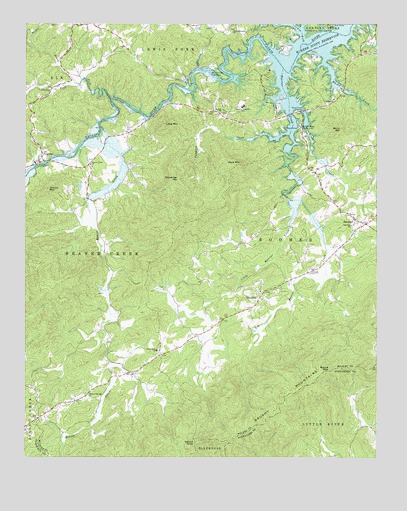
Boomer, NC USGS Topographic Map
Click on map above to begin viewing in our Map Viewer.

This topographic map contains these locations and features:
Feature Name Type Latitude Longitude GNIS ID View Map
Beaver CreekStreamN36.0957°W81.3484°980794View Map
Beaver Creek ChurchChurchN36.0846°W81.3518°980799View Map
Berry MountainSummitN36.0949°W81.2626°981042View Map
Big Warrior CreekStreamN36.0746°W81.2812°981469View Map
Blood CreekStreamN36.1024°W81.2806°981603View Map
Blood Creek OverlookLocaleN36.1007°W81.2762°981604View Map
BoomerPopulated PlaceN36.0674°W81.2537°1019254View Map
Boomer Post OfficePost OfficeN36.0675°W81.2545°2774246View Map
Boomer Road Access AreaParkN36.0954°W81.2776°981730View Map
Boomer Volunteer Fire DepartmentBuildingN36.0571°W81.2678°2638132View Map
Boomer-Ferguson SchoolSchoolN36.1012°W81.2973°981731View Map
Boone GapGapN36.0251°W81.2668°981737View Map
Broyhills Mill (historical)LocaleN36.0374°W81.2945°1959977View Map
Coffees Mill (historical)LocaleN36.0274°W81.3448°1959980View Map
Cosfort (historical)Populated PlaceN36.0990°W81.3337°1001505View Map
Davis Memorial ChurchChurchN36.1229°W81.3015°984009View Map
FergusonPopulated PlaceN36.0857°W81.3684°1020232View Map
Ferguson Fire DepartmentBuildingN36.0851°W81.3705°2638536View Map
Ferguson Post OfficePost OfficeN36.0851°W81.3704°2774180View Map
Gill MountainSummitN36.1110°W81.2523°1959987View Map
Gladys ForkStreamN36.1082°W81.3570°985717View Map
Goshen Bridge (historical)BridgeN36.1140°W81.2793°1959989View Map
Goshen ChurchChurchN36.1035°W81.2648°985847View Map
Goshen Volunteer Fire DepartmentBuildingN36.1169°W81.2547°2638260View Map
Goulds (historical)Populated PlaceN36.1029°W81.3387°1959990View Map
Greasy MountainSummitN36.0779°W81.3665°986008View Map
Greasy MountainSummitN36.0410°W81.3704°1959991View Map
Hollow Springs ChurchChurchN36.0190°W81.3512°986939View Map
Laws PondReservoirN36.0668°W81.2915°1000007View Map
Laws Pond DamDamN36.0668°W81.2915°1000008View Map
Lewis ForkStreamN36.1193°W81.2748°988397View Map
Little MountainSummitN36.0965°W81.3251°988712View Map
Little Rock Baptist ChurchChurchN36.0310°W81.3281°988761View Map
Little Warrior CreekStreamN36.0746°W81.2812°988797View Map
Mars MountainSummitN36.0849°W81.2984°989362View Map
McInnis MountainSummitN36.0412°W81.3276°1960003View Map
OakdalePopulated PlaceN36.0940°W81.3376°1960009View Map
Parsons Store (historical)LocaleN36.0318°W81.3115°1960012View Map
Pumpkin CreekStreamN36.0943°W81.2809°1022101View Map
Pumpkin Creek School (historical)SchoolN36.1049°W81.3118°1960017View Map
Smith Walker MountainSummitN36.0732°W81.3151°1960024View Map
Stoneman MountainSummitN36.0804°W81.3204°995539View Map
Stony ForkStreamN36.1035°W81.3443°995566View Map
ThankfulPopulated PlaceN36.0462°W81.2915°1022918View Map
Thankful Baptist ChurchChurchN36.0493°W81.2909°1960027View Map
Thankful SchoolSchoolN36.0482°W81.2912°1960028View Map
Township of Beaver CreekCivilN36.0705°W81.3402°1027322View Map
Township of BoomerCivilN36.0565°W81.2736°1027323View Map
W Kerr Scott ReservoirReservoirN36.1186°W81.2658°996649View Map
Walker ChurchChurchN36.0996°W81.3054°996698View Map
Walnut KnobSummitN36.0051°W81.3118°996747View Map
Walsh Fishing LakeReservoirN36.0618°W81.3415°1000003View Map
Walsh Fishing Lake DamDamN36.0618°W81.3415°1000004View Map
Warrior CreekStreamN36.1124°W81.2831°996811View Map
Warrior Creek Boat RampLocaleN36.1107°W81.3093°996812View Map
Whites CreekStreamN36.1171°W81.2679°997250View Map
Zion Hill Baptist ChurchChurchN36.0671°W81.2587°997802View Map

Note: Coordinates in the location and feature list above are referenced to NAD83 datum.


Copyright (C) 2008-2025 Ryan Niemi / Sunset Dynamics ... All Rights Reserved