TopoQuest Logo
Do you find TopoQuest useful?
Help keep TopoQuest running and adding new maps/features by donating!
Bitcoin:  19c7KJd3qBynnjoSw5npx9KScwjBe4ifkT
Litecoin:  LXs6TkuXGGXo1vDsWCkWVdjQX94eUKd6ui
Home View Maps Find Maps Find Places Resources & Links


Grant, Michigan Topographic Map

USGS Map Title: Grant, MI
USGS Map MRC: 43085C7
DRG (GeoTIFF) Download: o43085c7.tif


Neighboring USGS Topographic Map Quads:


  Fremont, MI  
43085D8
 

  Newaygo, MI  
43085D7
 

  Croton, MI  
43085D6
 

  Bridgeton, MI  
43085C8
 

  Grant, MI  
43085C7
 

  Sand Lake SW, MI  
43085C6
 

  Ravenna, MI  
43085B8
 

  Casnovia, MI  
43085B7
 

  Sparta, MI  
43085B6


Map MRC Location:

N44°
W86°
N44°
W85°
H8 H7 H6 H5 H4 H3 H2 H1
G8 G7 G6 G5 G4 G3 G2 G1
F8 F7 F6 F5 F4 F3 F2 F1
E8 E7 E6 E5 E4 E3 E2 E1
D8 D7 D6 D5 D4 D3 D2 D1
C8 C7 C6 C5 C4 C3 C2 C1
B8 B7 B6 B5 B4 B3 B2 B1
A8 A7 A6 A5 A4 A3 A2 A1
N43°
W86°
N43°
W85°

Grant, MI USGS 1:24K Topographic Map Preview:
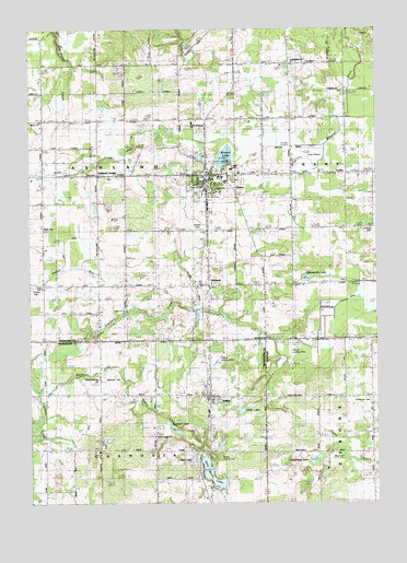
Grant, MI USGS Topographic Map
Click on map above to begin viewing in our Map Viewer.

This topographic map contains these locations and features:
Feature Name Type Latitude Longitude GNIS ID View Map
Applegarth SchoolSchoolN43.3036°W85.8500°620179View Map
AshlandPopulated PlaceN43.3078°W85.8112°620271View Map
Ashland - Grant Volunteer Fire DistrictBuildingN43.3364°W85.8121°2627051View Map
Ashland CemeteryCemeteryN43.3361°W85.8458°2541884View Map
Ashland CenterPopulated PlaceN43.3364°W85.8517°1617424View Map
Ashland Center Church of ChristChurchN43.3361°W85.8458°2542063View Map
Ashland Post Office (historical)Post OfficeN43.3364°W85.8517°2541860View Map
Ashland StationLocaleN43.3078°W85.8122°2541803View Map
BaileyPopulated PlaceN43.2778°W85.8103°620442View Map
Bailey Church of ChristChurchN43.2769°W85.8097°2571977View Map
Bailey Gospel ChurchChurchN43.2678°W85.8309°620449View Map
Bailey Post OfficePost OfficeN43.2786°W85.8097°2571976View Map
Bailey StationLocaleN43.2783°W85.8117°2571975View Map
Blanch LakeLakeN43.3412°W85.8045°621564View Map
Brooks Post Office (historical)Post OfficeN43.3678°W85.8203°2541852View Map
Casnovia Township Fire DepartmentBuildingN43.2780°W85.8111°2636218View Map
Chaney Landing Strip (historical)AirportN43.2881°W85.8069°2106587View Map
Chubbuck CemeteryCemeteryN43.2772°W85.7522°2106564View Map
Chubbuck SchoolSchoolN43.2775°W85.7617°623276View Map
City of GrantCivilN43.3348°W85.8092°1626384View Map
Coles LakeLakeN43.2742°W85.7991°623602View Map
Community ChurchChurchN43.3661°W85.7797°2106643View Map
Danish CemeteryCemeteryN43.3222°W85.8142°2106641View Map
Danish ChurchChurchN43.3222°W85.8145°624301View Map
Duitelmans LakeLakeN43.2614°W85.7728°624971View Map
Family Health Care ClinicHospitalN43.3364°W85.8106°2542057View Map
GrantPopulated PlaceN43.3361°W85.8109°627144View Map
Grant Airport (historical)AirportN43.3434°W85.7720°1623934View Map
Grant Assembly of God ChurchChurchN43.3328°W85.8078°2542065View Map
Grant Elementary SchoolSchoolN43.3358°W85.8056°2542080View Map
Grant High SchoolSchoolN43.3381°W85.8019°2542079View Map
Grant Medical CenterHospitalN43.3319°W85.8108°2542055View Map
Grant Middle SchoolSchoolN43.3361°W85.7972°2542078View Map
Grant Police DepartmentBuildingN43.3314°W85.8102°2542056View Map
Grant Post OfficePost OfficeN43.3336°W85.8122°2542059View Map
Grant Public LibraryBuildingN43.3353°W85.8036°2542053View Map
Grant Reformed ChurchChurchN43.3367°W85.8036°2542066View Map
Grant StationLocaleN43.3347°W85.8111°2542061View Map
Grant United Church of ChristChurchN43.3369°W85.8131°2542064View Map
Grant Wesleyan ChurchChurchN43.3503°W85.8161°2106644View Map
Half Moon LakeLakeN43.2577°W85.8098°627618View Map
Half Moon SchoolSchoolN43.2570°W85.8209°627624View Map
Hansen DrainCanalN43.3453°W85.8375°2106645View Map
Harvest Baptist ChurchChurchN43.3506°W85.8711°2106639View Map
Hillside CemeteryCemeteryN43.3222°W85.7520°628326View Map
Lake Post Office (historical)Post OfficeN43.3078°W85.8111°2541829View Map
Lambson SchoolSchoolN43.3653°W85.8206°630099View Map
Life Emergency Medical Station Grant StationBuildingN43.3364°W85.8121°2662071View Map
Moon Post Office (historical)Post OfficeN43.2639°W85.8106°2571691View Map
Moore County ParkParkN43.2622°W85.7578°2106586View Map
Mud LakeLakeN43.2617°W85.8167°632962View Map
North Casnovia Baptist ChurchChurchN43.2828°W85.8503°2571978View Map
North Casnovia SchoolSchoolN43.2789°W85.8512°633554View Map
Northland Church of ChristChurchN43.3736°W85.8006°2542062View Map
Ovidhall LakeLakeN43.2699°W85.8237°634237View Map
Ovidhall Lake CreekStreamN43.2781°W85.8720°634238View Map
Parkview CemeteryCemeteryN43.3361°W85.8014°2106642View Map
Patterson SchoolSchoolN43.3506°W85.8717°634476View Map
Pleasant Valley SchoolSchoolN43.3375°W85.7603°635124View Map
Post CreekStreamN43.2936°W85.7867°635322View Map
Salem SchoolSchoolN43.3664°W85.7800°637113View Map
Seamans CemeteryCemeteryN43.2828°W85.8484°637501View Map
Shippy CemeteryCemeteryN43.3070°W85.8745°637816View Map
Skipperville DrainCanalN43.3033°W85.7633°2106640View Map
Skipperville LakeLakeN43.3092°W85.7756°638070View Map
Township of AshlandCivilN43.3365°W85.8611°1625854View Map
Tyrone AirportAirportN43.2877°W85.7807°1623787View Map
Wheat SchoolSchoolN43.3217°W85.8701°1616253View Map
Wheeler DrainCanalN43.3536°W85.7603°1622125View Map
Windealt SchoolSchoolN43.3145°W85.7812°1616613View Map

Note: Coordinates in the location and feature list above are referenced to NAD83 datum.


Copyright (C) 2008-2024 Ryan Niemi / Sunset Dynamics ... All Rights Reserved