TopoQuest Logo
Do you find TopoQuest useful?
Help keep TopoQuest running and adding new maps/features by donating!
Bitcoin:  19c7KJd3qBynnjoSw5npx9KScwjBe4ifkT
Litecoin:  LXs6TkuXGGXo1vDsWCkWVdjQX94eUKd6ui
Home View Maps Find Maps Find Places Resources & Links


Hogansville, Georgia Topographic Map

USGS Map Title: Hogansville, GA
USGS Map MRC: 33084B8
DRG (GeoTIFF) Download: o33084b8.tif


Neighboring USGS Topographic Map Quads:


  Franklin, GA  
33085C1
 

  Newnan SW, GA  
33084C8
 

  Newnan South, GA  
33084C7
 

  Hillcrest, GA  
33085B1
 

  Hogansville, GA  
33084B8
 

  Grantville, GA  
33084B7
 

  La Grange, GA  
33085A1
 

  Mountville, GA  
33084A8
 

  Odessadale, GA  
33084A7


Map MRC Location:

N34°
W85°
N34°
W84°
H8 H7 H6 H5 H4 H3 H2 H1
G8 G7 G6 G5 G4 G3 G2 G1
F8 F7 F6 F5 F4 F3 F2 F1
E8 E7 E6 E5 E4 E3 E2 E1
D8 D7 D6 D5 D4 D3 D2 D1
C8 C7 C6 C5 C4 C3 C2 C1
B8 B7 B6 B5 B4 B3 B2 B1
A8 A7 A6 A5 A4 A3 A2 A1
N33°
W85°
N33°
W84°

Hogansville, GA USGS 1:24K Topographic Map Preview:
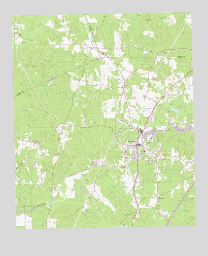
Hogansville, GA USGS Topographic Map
Click on map above to begin viewing in our Map Viewer.

This topographic map contains these locations and features:
Feature Name Type Latitude Longitude GNIS ID View Map
Antioch ChurchChurchN33.1815°W84.8947°310576View Map
Asbury CemeteryCemeteryN33.1632°W84.9966°1673035View Map
Asbury ChurchChurchN33.1615°W84.9958°354401View Map
Assembly of God ChurchChurchN33.1887°W84.9188°1673036View Map
Asta VillagePopulated PlaceN33.1301°W84.9758°1673037View Map
Bass CrossroadsPopulated PlaceN33.1426°W84.9013°310847View Map
Blue CreekStreamN33.1846°W84.9041°311546View Map
Blue Creek ReservoirReservoirN33.1812°W84.8825°2746851View Map
Boozer Chapel (historical)ChurchN33.1798°W84.9708°1673040View Map
Brays LakeviewPopulated PlaceN33.1476°W84.9713°1673041View Map
Brown CemeteryCemeteryN33.2454°W84.9663°354869View Map
Bruce CemeteryCemeteryN33.2323°W84.9769°311904View Map
Callaway DamDamN33.1635°W84.9449°340455View Map
Callaway LakeReservoirN33.1629°W84.9441°340456View Map
Cheathams PondReservoirN33.1959°W84.9281°1673051View Map
City of HogansvilleCivilN33.1675°W84.9029°2404708View Map
Clair LakeReservoirN33.1634°W84.9862°340135View Map
Clair Lake DamDamN33.1618°W84.9866°340134View Map
Cook CemeteryCemeteryN33.2373°W84.9960°355275View Map
CooksvillePopulated PlaceN33.2393°W84.9977°355281View Map
CorinthPopulated PlaceN33.2301°W84.9455°312974View Map
Corinth Academy (historical)SchoolN33.2326°W84.9488°347023View Map
Corinth Baptist ChurchChurchN33.2323°W84.9483°347024View Map
Corinth CemeteryCemeteryN33.2329°W84.9488°347025View Map
Corinth United Methodist ChurchChurchN33.2326°W84.9494°347026View Map
Dunbar MountainSummitN33.2457°W84.9066°331600View Map
Flat CreekStreamN33.1435°W84.9655°314183View Map
Gospel Mission ChurchChurchN33.1632°W84.9369°1673083View Map
Hammett AcresPopulated PlaceN33.1746°W84.9874°1673085View Map
Harmonia CemeteryCemeteryN33.2201°W84.9877°347063View Map
Harmonia School (historical)SchoolN33.2204°W84.9872°347064View Map
Harmony United Methodist ChurchChurchN33.2201°W84.9869°356176View Map
HarrisonvillePopulated PlaceN33.1760°W84.9885°356209View Map
Hills ChapelChurchN33.1618°W84.8755°315433View Map
HogansvillePopulated PlaceN33.1732°W84.9149°315520View Map
Hogansville City HallBuildingN33.1729°W84.9147°1673095View Map
Hogansville City Police DepartmentBuildingN33.1689°W84.9005°2733577View Map
Hogansville DivisionCivilN33.1567°W84.9303°1936321View Map
Hogansville Elementary SchoolSchoolN33.1695°W84.9095°2545532View Map
Hogansville High SchoolSchoolN33.1696°W84.9094°1673096View Map
Jackson CemeteryCemeteryN33.2201°W84.9902°316003View Map
Lakeview MeadowsPopulated PlaceN33.1382°W84.9797°1673104View Map
Mount Perry ChurchChurchN33.1607°W84.9227°318800View Map
Mount Zion CemeteryCemeteryN33.2307°W84.9363°348553View Map
Mount Zion ChurchChurchN33.2304°W84.9363°319001View Map
Myrtle Hill CemeteryCemeteryN33.1659°W84.8974°319183View Map
New Providence CemeteryCemeteryN33.1748°W84.9827°1673111View Map
Old Emmaus CemeteryCemeteryN33.1323°W84.9219°319972View Map
Old Providence CemeteryCemeteryN33.1759°W84.9822°1673114View Map
Providence Missionary Baptist ChurchChurchN33.1757°W84.9824°321197View Map
Reid CemeteryCemeteryN33.2126°W84.9510°321513View Map
Stinson CemeteryCemeteryN33.1943°W84.9899°323630View Map
T Eugene Crocker Primary SchoolSchoolN33.1768°W84.9047°1685688View Map
TrimblePopulated PlaceN33.2021°W84.8922°333263View Map
Troup County Fire Department Station 11BuildingN33.1663°W84.9006°2604586View Map
Troup County Fire Department Station 8BuildingN33.1597°W84.9496°2604587View Map
Walley ChapelChurchN33.2301°W84.9352°324798View Map
Walley Chapel CemeteryCemeteryN33.2307°W84.9352°348628View Map
Welcome All ChurchChurchN33.2071°W84.9233°324971View Map
West End SchoolSchoolN33.1693°W84.9224°325044View Map
West View CemeteryCemeteryN33.1665°W84.9241°325079View Map
Word CemeteryCemeteryN33.1701°W84.9072°325560View Map
Yellow Jacket Creek Structure Number 15 LakeReservoirN33.1936°W84.8891°340368View Map

Note: Coordinates in the location and feature list above are referenced to NAD83 datum.


Copyright (C) 2008-2024 Ryan Niemi / Sunset Dynamics ... All Rights Reserved