TopoQuest Logo
Do you find TopoQuest useful?
Help keep TopoQuest running and adding new maps/features by donating!
Bitcoin:  19c7KJd3qBynnjoSw5npx9KScwjBe4ifkT
Litecoin:  LXs6TkuXGGXo1vDsWCkWVdjQX94eUKd6ui
Home View Maps Find Maps Find Places Resources & Links


Putnam, New York Topographic Map

USGS Map Title: Putnam, NY
USGS Map MRC: 43073F4
DRG (GeoTIFF) Download: o43073f4.tif


Neighboring USGS Topographic Map Quads:


  Graphite, NY  
43073G5
 

  Ticonderoga, NY  
43073G4
 

  Orwell, VT  
43073G3
 

  Silver Bay, NY  
43073F5
 

  Putnam, NY  
43073F4
 

  Benson, VT  
43073F3
 

  Shelving Rock, NY  
43073E5
 

  Whitehall, NY  
43073E4
 

  Thorn Hill, NY  
43073E3


Map MRC Location:

N44°
W74°
N44°
W73°
H8 H7 H6 H5 H4 H3 H2 H1
G8 G7 G6 G5 G4 G3 G2 G1
F8 F7 F6 F5 F4 F3 F2 F1
E8 E7 E6 E5 E4 E3 E2 E1
D8 D7 D6 D5 D4 D3 D2 D1
C8 C7 C6 C5 C4 C3 C2 C1
B8 B7 B6 B5 B4 B3 B2 B1
A8 A7 A6 A5 A4 A3 A2 A1
N43°
W74°
N43°
W73°

Putnam, NY USGS 1:24K Topographic Map Preview:
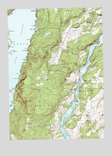
Putnam, NY USGS Topographic Map
Click on map above to begin viewing in our Map Viewer.

This topographic map contains these locations and features:
Feature Name Type Latitude Longitude GNIS ID View Map
Agnes IslandIslandN43.6576°W73.4987°942206View Map
Arcady Country ClubLocaleN43.7140°W73.4987°974301View Map
Barret BayBayN43.6581°W73.4173°943078View Map
Bluff HeadCapeN43.6717°W73.4968°944345View Map
Brimstone HillSummitN43.7467°W73.4185°944754View Map
Burnt PointCapeN43.7206°W73.4707°945265View Map
Camp EndionLocaleN43.7420°W73.3751°945578View Map
Camp MohicanLocaleN43.7103°W73.4737°945625View Map
Camp SagamoreLocaleN43.7478°W73.4607°945653View Map
Cedar MountainSummitN43.7034°W73.3846°1456804View Map
Chilson BendBendN43.7370°W73.4073°973713View Map
Chubbs DockLocaleN43.6370°W73.4340°973716View Map
Chubbs DockPopulated PlaceN43.6370°W73.4340°973493View Map
Chubbs Dock LightLocaleN43.6367°W73.4296°974349View Map
Clark HollowValleyN43.7078°W73.4721°946766View Map
Clark Hollow BayBayN43.7070°W73.4732°946767View Map
ClemonsPopulated PlaceN43.6365°W73.4454°946842View Map
Clemons Post OfficePost OfficeN43.6322°W73.4469°2598363View Map
Cold SpringPopulated PlaceN43.6715°W73.4068°1460404View Map
Crow PointCapeN43.7334°W73.4643°947846View Map
Dark BayBayN43.7390°W73.4604°948031View Map
DresdenPopulated PlaceN43.6726°W73.4107°972393View Map
Dresden CenterPopulated PlaceN43.6334°W73.4451°978649View Map
Dresden Station Post OfficePost OfficeN43.6720°W73.4112°973714View Map
Fish HillSummitN43.6398°W73.3962°1457436View Map
Gallup PointCapeN43.6745°W73.4059°1457514View Map
Gillette CemeteryCemeteryN43.6717°W73.4910°951121View Map
Green PointCapeN43.6742°W73.4921°951715View Map
Gull BayBayN43.7317°W73.4629°951926View Map
Gull IslandIslandN43.7312°W73.4690°951929View Map
HaguePopulated PlaceN43.7453°W73.4985°951990View Map
Hague BrookStreamN43.7445°W73.4962°970188View Map
Hogback MountainSummitN43.6342°W73.4823°952957View Map
Horton BrookStreamN43.6601°W73.4121°1457897View Map
Horton MarshSwampN43.6570°W73.4093°1457898View Map
Jabe Pond BrookStreamN43.7253°W73.4973°953868View Map
Jenkins PointCapeN43.7290°W73.4968°953982View Map
Kline HillSummitN43.6467°W73.3971°1458114View Map
Lamb Shanty BayBayN43.7012°W73.4771°955001View Map
Mallory IslandIslandN43.7123°W73.4743°956310View Map
Maple BendBendN43.6476°W73.4165°1458343View Map
Maple Bend IslandIslandN43.6470°W73.4251°956389View Map
Mill BayBayN43.7401°W73.3784°957193View Map
Mill BrookStreamN43.7370°W73.3826°957198View Map
Moore HillSummitN43.7373°W73.4232°957597View Map
Mount TomSummitN43.6959°W73.4109°967616View Map
Mud PondLakeN43.7253°W73.4478°958078View Map
Odell IslandsIslandN43.6840°W73.4923°959222View Map
Old Maid Place Lighthouse (historical)LocaleN43.6604°W73.4121°1460358View Map
Ottenburgs RampLocaleN43.6487°W73.4271°973715View Map
Pardo PointCapeN43.7187°W73.4948°959860View Map
Pudding IslandIslandN43.7081°W73.4976°961938View Map
Pulpit PointCapeN43.6945°W73.3993°961954View Map
PutnamPopulated PlaceN43.7467°W73.3971°973622View Map
Putnam CemeteryCemeteryN43.7027°W73.4373°962007View Map
Putnam Central SchoolSchoolN43.7478°W73.3944°2499797View Map
Putnam ChurchChurchN43.7151°W73.4285°962008View Map
Putnam Station Post OfficePost OfficeN43.7406°W73.4032°978407View Map
Putnam Volunteer Fire CompanyBuildingN43.7380°W73.4092°2718550View Map
Racket IslandIslandN43.6884°W73.4860°962124View Map
Red Rock BayBayN43.6798°W73.4007°1459156View Map
Rock BrothersIslandN43.7484°W73.4629°962692View Map
Scotch Bonnet IslandIslandN43.7095°W73.4929°964660View Map
Sheldrick HillSummitN43.6709°W73.3915°1459487View Map
Skerrey PointCapeN43.7303°W73.4643°965348View Map
Skipper IslandIslandN43.7065°W73.4968°965363View Map
Smith BayBayN43.7217°W73.4676°965453View Map
Spruce MountainSummitN43.6617°W73.4757°966137View Map
Stark PointCapeN43.7103°W73.4946°966253View Map
Swale SchoolSchoolN43.6445°W73.3948°1459798View Map
The NarrowsGapN43.6612°W73.4121°1460479View Map

Note: Coordinates in the location and feature list above are referenced to NAD83 datum.


Copyright (C) 2008-2024 Ryan Niemi / Sunset Dynamics ... All Rights Reserved