TopoQuest Logo
Do you find TopoQuest useful?
Help keep TopoQuest running and adding new maps/features by donating!
Bitcoin:  19c7KJd3qBynnjoSw5npx9KScwjBe4ifkT
Litecoin:  LXs6TkuXGGXo1vDsWCkWVdjQX94eUKd6ui
Home View Maps Find Maps Find Places Resources & Links


Grass Lake, Michigan Topographic Map

USGS Map Title: Grass Lake, MI
USGS Map MRC: 42084C2
DRG (GeoTIFF) Download: o42084c2.tif


Neighboring USGS Topographic Map Quads:


  Pleasant Lake, MI  
42084D3
 

  Stockbridge, MI  
42084D2
 

  Gregory, MI  
42084D1
 

  Gilletts Lake, MI  
42084C3
 

  Grass Lake, MI  
42084C2
 

  Chelsea, MI  
42084C1
 

  Michigan Center, MI  
42084B3
 

  Norvell, MI  
42084B2
 

  Manchester, MI  
42084B1


Map MRC Location:

N43°
W85°
N43°
W84°
H8 H7 H6 H5 H4 H3 H2 H1
G8 G7 G6 G5 G4 G3 G2 G1
F8 F7 F6 F5 F4 F3 F2 F1
E8 E7 E6 E5 E4 E3 E2 E1
D8 D7 D6 D5 D4 D3 D2 D1
C8 C7 C6 C5 C4 C3 C2 C1
B8 B7 B6 B5 B4 B3 B2 B1
A8 A7 A6 A5 A4 A3 A2 A1
N42°
W85°
N42°
W84°

Grass Lake, MI USGS 1:24K Topographic Map Preview:
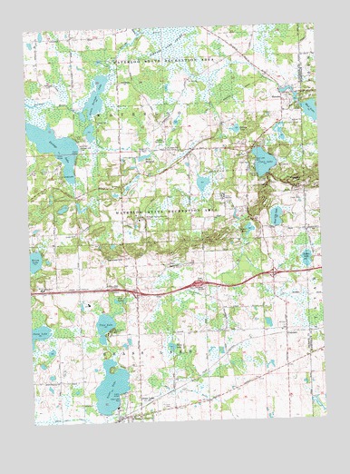
Grass Lake, MI USGS Topographic Map
Click on map above to begin viewing in our Map Viewer.

This topographic map contains these locations and features:
Feature Name Type Latitude Longitude GNIS ID View Map
Calderone Farms Golf ClubLocaleN42.3006°W84.2342°2633017View Map
Camp WaterlooLocaleN42.3209°W84.1663°622647View Map
Clear LakeLakeN42.3316°W84.1484°623408View Map
Clear Lake ParkParkN42.3325°W84.1527°623436View Map
Fa-Ho-Lo ParkParkN42.2642°W84.2103°2633015View Map
Fa-Ho-Lo ParkParkN42.2792°W84.2144°625731View Map
Family Worship CenterChurchN42.2630°W84.2032°2633006View Map
Federated Church of Grass LakesChurchN42.2517°W84.2075°2633008View Map
Four Lakes Family CampgroundLocaleN42.3472°W84.2100°2633020View Map
FranciscoPopulated PlaceN42.2773°W84.1405°626399View Map
Francisco Post Office (historical)Post OfficeN42.2772°W84.1406°2631483View Map
Francisco Station (historical)LocaleN42.2772°W84.1406°2633075View Map
Grass LakeLakeN42.2609°W84.2166°627177View Map
Grass LakePopulated PlaceN42.2509°W84.2130°627210View Map
Grass Lake Assembly of God ChurchChurchN42.2763°W84.2048°2633003View Map
Grass Lake Baptist ChurchChurchN42.2522°W84.1978°2633009View Map
Grass Lake Charter Township Fire DepartmentBuildingN42.2552°W84.1880°2636237View Map
Grass Lake DrainCanalN42.2517°W84.2338°627219View Map
Grass Lake Fire DepartmentBuildingN42.2506°W84.2139°2633014View Map
Grass Lake Historical MarkerParkN42.2514°W84.2119°2630740View Map
Grass Lake Medical CenterHospitalN42.2541°W84.1867°2633013View Map
Grass Lake ParkParkN42.2570°W84.2125°627220View Map
Grass Lake PitMineN42.3228°W84.1342°2726057View Map
Grass Lake Police DepartmentBuildingN42.2514°W84.2139°2633012View Map
Grass Lake Post OfficePost OfficeN42.2513°W84.2111°2633011View Map
Grass Lake Rest AreaLocaleN42.2931°W84.2147°2630734View Map
Grass Lake Station (historical)LocaleN42.2514°W84.2133°2633010View Map
Grass Lake United Methodist ChurchChurchN42.2514°W84.2083°2633007View Map
Holiday CampgroundsLocaleN42.2914°W84.2369°2633018View Map
Honey CreekStreamN42.3734°W84.2005°628524View Map
Interchange 150CrossingN42.2911°W84.2044°2630717View Map
Interchange 153CrossingN42.2964°W84.1458°2630716View Map
Jackson Area Historical MarkerParkN42.2925°W84.2148°2630741View Map
Jackson District Library-Grass Lake BranchBuildingN42.2508°W84.2141°2633016View Map
Little Portage LakeLakeN42.3523°W84.2202°630739View Map
Locker LakeLakeN42.3105°W84.1554°630854View Map
Loveland Road CemeteryCemeteryN42.3182°W84.1308°2646774View Map
Michigan Baptist Assembly CampLocaleN42.3142°W84.2019°632204View Map
Michigan Central Railroad Depot Historical MarkerParkN42.2514°W84.2119°2630739View Map
Miles CemeteryCemeteryN42.2875°W84.1694°2633093View Map
Moss CemeteryCemeteryN42.3722°W84.2295°2633123View Map
Mount Hope CemeteryCemeteryN42.3367°W84.1902°632800View Map
Mount Hope ChurchChurchN42.3245°W84.2102°632810View Map
Mount Pleasant CemeteryCemeteryN42.3211°W84.2492°2633094View Map
Mud LakeLakeN42.3477°W84.1276°633065View Map
Mud LakeLakeN42.2884°W84.2136°632909View Map
Notten LakeLakeN42.3007°W84.1312°633770View Map
Oakwood CemeteryCemeteryN42.2556°W84.1941°625163View Map
Pond Lily LakeLakeN42.3145°W84.1437°635219View Map
Portage LakeLakeN42.3384°W84.2347°635280View Map
Portage Lake ParkParkN42.3373°W84.2272°635282View Map
Prospect HillSummitN42.3256°W84.1311°635481View Map
Riley LakeLakeN42.2737°W84.1899°635937View Map
Sackrider HillSummitN42.3020°W84.2091°636456View Map
Saint Jacob ChurchChurchN42.3584°W84.1802°636682View Map
Saint Jacob's German Lutheran CemeteryCemeteryN42.3586°W84.1792°2633122View Map
Saint John's CemeteryCemeteryN42.2786°W84.1650°2633101View Map
Spring LakeLakeN42.3423°W84.1598°638573View Map
Tims LakeLakeN42.2808°W84.2185°1614874View Map
Township of WaterlooCivilN42.3659°W84.1910°1627219View Map
TristPopulated PlaceN42.3361°W84.2002°1617898View Map
Trist MillpondLakeN42.3339°W84.1998°1615096View Map
Trist Post Office (historical)Post OfficeN42.3361°W84.2003°2633085View Map
Village of Grass LakeCivilN42.2511°W84.2073°2398195View Map
Vinings Trailer ParkPopulated PlaceN42.3400°W84.2256°2632974View Map
WaterlooPopulated PlaceN42.3531°W84.1402°1615849View Map
Waterloo Golf CourseLocaleN42.3392°W84.1930°1623693View Map
Waterloo Methodist ChurchChurchN42.3522°W84.1379°2633019View Map
Waterloo Post Office (historical)Post OfficeN42.3531°W84.1403°2633084View Map
Waterloo State Recreation AreaParkN42.3614°W84.1908°1615852View Map
Waterloo Village CemeteryCemeteryN42.3486°W84.1356°2633121View Map
Welch LakeLakeN42.3022°W84.2495°1615983View Map

Note: Coordinates in the location and feature list above are referenced to NAD83 datum.


Copyright (C) 2008-2025 Ryan Niemi / Sunset Dynamics ... All Rights Reserved