TopoQuest Logo
Do you find TopoQuest useful?
Help keep TopoQuest running and adding new maps/features by donating!
Bitcoin:  19c7KJd3qBynnjoSw5npx9KScwjBe4ifkT
Litecoin:  LXs6TkuXGGXo1vDsWCkWVdjQX94eUKd6ui
Home View Maps Find Maps Find Places Resources & Links


Grayton Beach, Florida Topographic Map

USGS Map Title: Grayton Beach, FL
USGS Map MRC: 30086C2
DRG (GeoTIFF) Download: o30086c2.tif


Neighboring USGS Topographic Map Quads:


  Choctaw Beach, FL  
30086D3
 

  Freeport, FL  
30086D2
 

  Bunker, FL  
30086D1
 

  Miramar Beach, FL  
30086C3
 

  Grayton Beach, FL  
30086C2
 

  Point Washington, FL  
30086C1


Map MRC Location:

N31°
W87°
N31°
W86°
H8 H7 H6 H5 H4 H3 H2 H1
G8 G7 G6 G5 G4 G3 G2 G1
F8 F7 F6 F5 F4 F3 F2 F1
E8 E7 E6 E5 E4 E3 E2 E1
D8 D7 D6 D5 D4 D3 D2 D1
C8 C7 C6 C5 C4 C3 C2 C1
B8 B7 B6 B5 B4 B3 B2 B1
A8 A7 A6 A5 A4 A3 A2 A1
N30°
W87°
N30°
W86°

Grayton Beach, FL USGS 1:24K Topographic Map Preview:
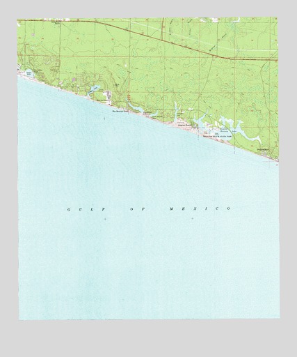
Grayton Beach, FL USGS Topographic Map
Click on map above to begin viewing in our Map Viewer.

This topographic map contains these locations and features:
Feature Name Type Latitude Longitude GNIS ID View Map
Alligator LakeLakeN30.3346°W86.1742°277797View Map
Beach HighlandsPopulated PlaceN30.3530°W86.2494°1955355View Map
Big Redfish LakeLakeN30.3378°W86.1931°278731View Map
Blue Gulf BeachPopulated PlaceN30.3413°W86.2058°279019View Map
Blue MountainSummitN30.3477°W86.2027°279046View Map
Blue Mountain BeachPopulated PlaceN30.3374°W86.1972°279047View Map
Cano SquareLocaleN30.3741°W86.2280°295878View Map
Draper LakeLakeN30.3457°W86.2135°281750View Map
Dune Allen BeachPopulated PlaceN30.3530°W86.2422°281859View Map
Grayton BeachPopulated PlaceN30.3308°W86.1649°283356View Map
Grayton Beach State ParkParkN30.3249°W86.1541°283357View Map
Irwin CreekStreamN30.3446°W86.2269°1983617View Map
Lake FoxLakeN30.3569°W86.2352°2437387View Map
Little Redfish LakeLakeN30.3355°W86.1833°285774View Map
Oyster LakeLakeN30.3525°W86.2442°288345View Map
Santa Rosa Beach Post OfficePost OfficeN30.3750°W86.2437°2759178View Map
Santa Rosa CemeteryCemeteryN30.3535°W86.2302°290661View Map
Seagrove BeachPopulated PlaceN30.3185°W86.1302°290793View Map
SeasidePopulated PlaceN30.3210°W86.1416°1955357View Map
South Walton Fire District Station 2BuildingN30.3291°W86.1269°2644160View Map
Walton Beaches DivisionCivilN30.3422°W86.2002°2583401View Map
Walton County Sheriff's Office SouthBuildingN30.3723°W86.1788°2754467View Map
WatercolorPopulated PlaceN30.3224°W86.1458°1955356View Map
Western LakeLakeN30.3287°W86.1519°293134View Map

Note: Coordinates in the location and feature list above are referenced to NAD83 datum.


Copyright (C) 2008-2024 Ryan Niemi / Sunset Dynamics ... All Rights Reserved