TopoQuest Logo
Do you find TopoQuest useful?
Help keep TopoQuest running and adding new maps/features by donating!
Bitcoin:  19c7KJd3qBynnjoSw5npx9KScwjBe4ifkT
Litecoin:  LXs6TkuXGGXo1vDsWCkWVdjQX94eUKd6ui
Home View Maps Find Maps Find Places Resources & Links


Freeport, Florida Topographic Map

USGS Map Title: Freeport, FL
USGS Map MRC: 30086D2
DRG (GeoTIFF) Download: o30086d2.tif


Neighboring USGS Topographic Map Quads:


  Niceville SE, FL  
30086E3
 

  Portland, FL  
30086E2
 

  Rock Hill, FL  
30086E1
 

  Choctaw Beach, FL  
30086D3
 

  Freeport, FL  
30086D2
 

  Bunker, FL  
30086D1
 

  Miramar Beach, FL  
30086C3
 

  Grayton Beach, FL  
30086C2
 

  Point Washington, FL  
30086C1


Map MRC Location:

N31°
W87°
N31°
W86°
H8 H7 H6 H5 H4 H3 H2 H1
G8 G7 G6 G5 G4 G3 G2 G1
F8 F7 F6 F5 F4 F3 F2 F1
E8 E7 E6 E5 E4 E3 E2 E1
D8 D7 D6 D5 D4 D3 D2 D1
C8 C7 C6 C5 C4 C3 C2 C1
B8 B7 B6 B5 B4 B3 B2 B1
A8 A7 A6 A5 A4 A3 A2 A1
N30°
W87°
N30°
W86°

Freeport, FL USGS 1:24K Topographic Map Preview:
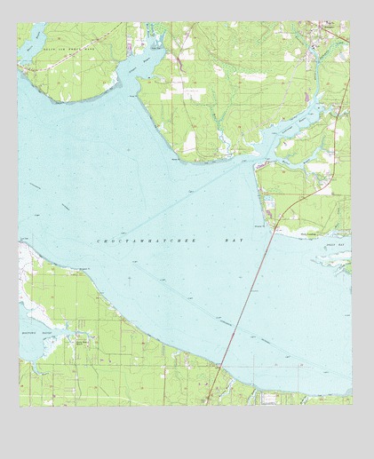
Freeport, FL USGS Topographic Map
Click on map above to begin viewing in our Map Viewer.

This topographic map contains these locations and features:
Feature Name Type Latitude Longitude GNIS ID View Map
Alaqua BayouBayN30.4859°W86.2041°277722View Map
Alaqua CreekStreamN30.4944°W86.1986°277724View Map
Alaqua PointCapeN30.4755°W86.2338°277726View Map
Alligator PointCapeN30.4191°W86.2269°277803View Map
Basin BayouBayN30.4932°W86.2442°278147View Map
Basin Bayou State Recreation AreaParkN30.4799°W86.2402°303995View Map
Bay ViewPopulated PlaceN30.4596°W86.1772°301672View Map
Bear CreekStreamN30.4302°W86.1344°278299View Map
Bear CreekStreamN30.4563°W86.1697°278301View Map
Bowman BayouStreamN30.3833°W86.1686°279296View Map
Choctaw Bay EstatesPopulated PlaceN30.3771°W86.1366°301675View Map
Churchill BayouStreamN30.3896°W86.2444°280459View Map
Fluffy LandingPopulated PlaceN30.4310°W86.1361°282636View Map
Fourmile CreekStreamN30.4738°W86.1377°282746View Map
FreeportPopulated PlaceN30.4983°W86.1361°282806View Map
Freeport Fire DepartmentBuildingN30.4955°W86.1342°2644313View Map
Freeport PlazaLocaleN30.4980°W86.1266°295870View Map
Goodwin CreekStreamN30.4996°W86.1980°283184View Map
Jolly BayBayN30.4273°W86.1280°284898View Map
La Grange PointPopulated PlaceN30.4316°W86.1549°301673View Map
Lafayette CreekStreamN30.4860°W86.1366°285206View Map
LaGrange BayouBayN30.4650°W86.1480°285194View Map
Lion ParkParkN30.3983°W86.2291°285568View Map
Littles BayouStreamN30.3799°W86.1605°285860View Map
Live Oak PointCapeN30.4288°W86.2491°285881View Map
Mallet BayouBayN30.4530°W86.1440°286328View Map
McQuage BayouStreamN30.3777°W86.1413°286651View Map
Motes PointCapeN30.4563°W86.1880°287189View Map
Nancys CutoffStreamN30.4171°W86.1316°287527View Map
Piney PointCapeN30.4766°W86.2038°288961View Map
Ramsey BranchStreamN30.4710°W86.1347°289459View Map
Santa Rosa BeachPopulated PlaceN30.3960°W86.2288°290660View Map
South Walton Fire District HeadquartersBuildingN30.3874°W86.2294°2644038View Map
Walton County Fire Rescue Station 12BuildingN30.4955°W86.1345°2644590View Map
Walton County Sheriff's Office Freeport SubstationBuildingN30.4938°W86.1363°2754510View Map
West BayouStreamN30.4913°W86.1997°293037View Map
Wheeler PointCapeN30.4338°W86.1566°293176View Map

Note: Coordinates in the location and feature list above are referenced to NAD83 datum.


Copyright (C) 2008-2025 Ryan Niemi / Sunset Dynamics ... All Rights Reserved