TopoQuest Logo
Do you find TopoQuest useful?
Help keep TopoQuest running and adding new maps/features by donating!
Bitcoin:  19c7KJd3qBynnjoSw5npx9KScwjBe4ifkT
Litecoin:  LXs6TkuXGGXo1vDsWCkWVdjQX94eUKd6ui
Home View Maps Find Maps Find Places Resources & Links


Bunker, Florida Topographic Map

USGS Map Title: Bunker, FL
USGS Map MRC: 30086D1
DRG (GeoTIFF) Download: o30086d1.tif


Neighboring USGS Topographic Map Quads:


  Portland, FL  
30086E2
 

  Rock Hill, FL  
30086E1
 

  Redbay, FL  
30085E8
 

  Freeport, FL  
30086D2
 

  Bunker, FL  
30086D1


  Grayton Beach, FL  
30086C2
 

  Point Washington, FL  
30086C1


Map MRC Location:

N31°
W87°
N31°
W86°
H8 H7 H6 H5 H4 H3 H2 H1
G8 G7 G6 G5 G4 G3 G2 G1
F8 F7 F6 F5 F4 F3 F2 F1
E8 E7 E6 E5 E4 E3 E2 E1
D8 D7 D6 D5 D4 D3 D2 D1
C8 C7 C6 C5 C4 C3 C2 C1
B8 B7 B6 B5 B4 B3 B2 B1
A8 A7 A6 A5 A4 A3 A2 A1
N30°
W87°
N30°
W86°

Bunker, FL USGS 1:24K Topographic Map Preview:
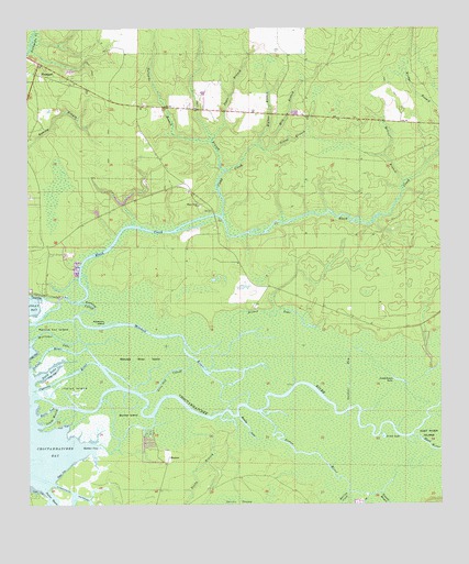
Bunker, FL USGS Topographic Map
Click on map above to begin viewing in our Map Viewer.

This topographic map contains these locations and features:
Feature Name Type Latitude Longitude GNIS ID View Map
Bells LegStreamN30.3985°W86.1224°278462View Map
Bishop LakeSwampN30.4249°W86.0515°278864View Map
Black CreekStreamN30.4235°W86.1224°278888View Map
Black Creek ChurchChurchN30.4538°W86.0727°278891View Map
BunkerPopulated PlaceN30.3874°W86.0827°294703View Map
Bunker CoveBayN30.3890°W86.1052°279673View Map
Bunker IslandSwampN30.3996°W86.0953°279679View Map
Camp CreekStreamN30.4508°W86.0655°279886View Map
Choctawhatchee RiverStreamN30.4038°W86.1236°294307View Map
Cypress RiverStreamN30.4058°W86.1236°281242View Map
Duck LakeBayN30.4098°W86.1195°281813View Map
Dugger FieldAirportN30.4957°W86.0925°2676637View Map
East RiverStreamN30.3930°W86.0088°282021View Map
Eden Gardens State ParkParkN30.3780°W86.1222°303994View Map
Freeport DivisionCivilN30.4758°W86.0925°1935774View Map
Freeport Post OfficePost OfficeN30.4987°W86.1202°2759165View Map
Gardner RunStreamN30.4013°W86.0277°282938View Map
Indian IslandSwampN30.4057°W86.1095°284505View Map
Indian RiverStreamN30.4105°W86.1247°284531View Map
Inside LakeLakeN30.3929°W86.0175°284559View Map
Joyce BranchStreamN30.4710°W86.0683°284949View Map
Live Oak CutoffStreamN30.4041°W86.0911°285868View Map
McIver BranchStreamN30.4599°W86.0108°286622View Map
Mitchell RiverStreamN30.4230°W86.1249°287015View Map
Mitchell River IslandSwampN30.4146°W86.0927°287016View Map
Muddy LakeLakeN30.3955°W86.0590°287437View Map
Nancys Cut IslandIslandN30.4213°W86.1161°287526View Map
Old Bay ViewPopulated PlaceN30.4371°W86.1099°301676View Map
Opossum IslandIslandN30.4227°W86.0997°288180View Map
Pate BranchStreamN30.4630°W86.0644°288565View Map
Reedy BranchStreamN30.3935°W86.0758°289597View Map
Roaring CreekStreamN30.3780°W86.0283°289770View Map
Rushing CutoffStreamN30.4249°W86.1097°290064View Map
Silcox BranchStreamN30.4694°W86.0547°291104View Map
Sister RiverStreamN30.3988°W86.0544°291181View Map
Smokehouse LakeLakeN30.4077°W86.0127°291269View Map
South MouthStreamN30.3958°W86.1213°291398View Map
Tenmile BranchStreamN30.3783°W86.0180°292107View Map
Tucker BayouStreamN30.3791°W86.1208°292492View Map
Turnpike BranchStreamN30.4710°W86.0686°292568View Map
Walker BranchStreamN30.4694°W86.0547°292830View Map
Williams LakeStreamN30.4171°W86.1244°293331View Map

Note: Coordinates in the location and feature list above are referenced to NAD83 datum.


Copyright (C) 2008-2024 Ryan Niemi / Sunset Dynamics ... All Rights Reserved