TopoQuest Logo
Do you find TopoQuest useful?
Help keep TopoQuest running and adding new maps/features by donating!
Bitcoin:  19c7KJd3qBynnjoSw5npx9KScwjBe4ifkT
Litecoin:  LXs6TkuXGGXo1vDsWCkWVdjQX94eUKd6ui
Home View Maps Find Maps Find Places Resources & Links


Choctaw Beach, Florida Topographic Map

USGS Map Title: Choctaw Beach, FL
USGS Map MRC: 30086D3
DRG (GeoTIFF) Download: o30086d3.tif


Neighboring USGS Topographic Map Quads:


  Niceville, FL  
30086E4
 

  Niceville SE, FL  
30086E3
 

  Portland, FL  
30086E2
 

  Destin, FL  
30086D4
 

  Choctaw Beach, FL  
30086D3
 

  Freeport, FL  
30086D2


  Miramar Beach, FL  
30086C3
 

  Grayton Beach, FL  
30086C2


Map MRC Location:

N31°
W87°
N31°
W86°
H8 H7 H6 H5 H4 H3 H2 H1
G8 G7 G6 G5 G4 G3 G2 G1
F8 F7 F6 F5 F4 F3 F2 F1
E8 E7 E6 E5 E4 E3 E2 E1
D8 D7 D6 D5 D4 D3 D2 D1
C8 C7 C6 C5 C4 C3 C2 C1
B8 B7 B6 B5 B4 B3 B2 B1
A8 A7 A6 A5 A4 A3 A2 A1
N30°
W87°
N30°
W86°

Choctaw Beach, FL USGS 1:24K Topographic Map Preview:
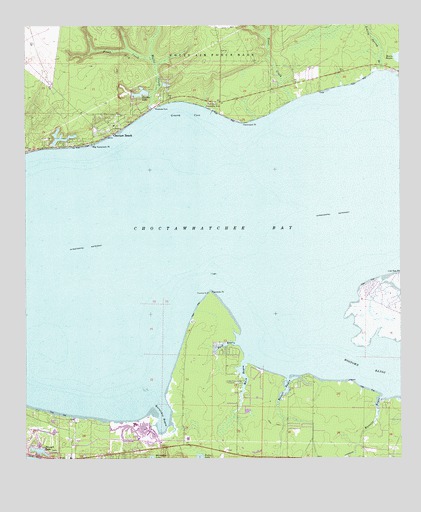
Choctaw Beach, FL USGS Topographic Map
Click on map above to begin viewing in our Map Viewer.

This topographic map contains these locations and features:
Feature Name Type Latitude Longitude GNIS ID View Map
Baytowne MarinaLocaleN30.3874°W86.3263°1955352View Map
Big HammockPopulated PlaceN30.4666°W86.3680°301671View Map
Big Hammock PointCapeN30.4666°W86.3522°278682View Map
Buck BayouStreamN30.4085°W86.3044°279551View Map
Choctaw BeachPopulated PlaceN30.4713°W86.3433°280410View Map
Choctawhatchee BayBayN30.4323°W86.3502°293962View Map
Fort Rucker Recreation AreaParkN30.4760°W86.3111°282707View Map
Foster Burgess PondLakeN30.4933°W86.3471°298139View Map
Fourmile PointCapeN30.4224°W86.3130°282750View Map
Grassy CoveBayN30.4732°W86.3253°283311View Map
GroshPopulated PlaceN30.3952°W86.2827°301669View Map
Hammock PointCapeN30.4727°W86.3005°283658View Map
Hewett BayouStreamN30.3980°W86.2866°283931View Map
Hogtown BayouBayN30.4016°W86.2577°284128View Map
Horseshoe BayouBayN30.3865°W86.3290°284295View Map
Linton Spring BranchStreamN30.4863°W86.2586°285567View Map
Mack BayouStreamN30.4027°W86.3016°286259View Map
Miramar Beach Census Designated PlaceCensusN30.3853°W86.3441°2403296View Map
Miramar Beach Post OfficePost OfficeN30.3773°W86.3591°2783396View Map
Mullet CreekStreamN30.4760°W86.3319°287456View Map
Mussett BayouStreamN30.3927°W86.2563°287492View Map
Piney CreekStreamN30.4899°W86.3316°288948View Map
Sacred Heart Hospital on the Emerald CoastHospitalN30.3786°W86.3067°2662470View Map
SandestinPopulated PlaceN30.3799°W86.3302°1955351View Map
SeascapePopulated PlaceN30.3760°W86.3716°1955354View Map
Sharon LakeReservoirN30.4807°W86.3362°290936View Map
South Walton Fire District Station 4BuildingN30.3833°W86.3052°2644236View Map
South Walton Fire District Station 5 Miramar BeachBuildingN30.3805°W86.3594°2644059View Map
Stewart LakeLakeN30.3776°W86.3706°291694View Map
The Village of Baytowne WharfPopulated PlaceN30.3871°W86.3252°1955353View Map
Trout CreekStreamN30.4785°W86.2849°292472View Map
Turquoise BeachPopulated PlaceN30.4080°W86.3113°301670View Map
Walton County Fire Rescue Station 10 / Tri - Village Fire Department Choctaw BeachBuildingN30.4667°W86.3512°2644082View Map
WWAV-FM (Santa Rosa Beach)TowerN30.3755°W86.3608°309121View Map

Note: Coordinates in the location and feature list above are referenced to NAD83 datum.


Copyright (C) 2008-2024 Ryan Niemi / Sunset Dynamics ... All Rights Reserved