TopoQuest Logo
Do you find TopoQuest useful?
Help keep TopoQuest running and adding new maps/features by donating!
Bitcoin:  19c7KJd3qBynnjoSw5npx9KScwjBe4ifkT
Litecoin:  LXs6TkuXGGXo1vDsWCkWVdjQX94eUKd6ui
Home View Maps Find Maps Find Places Resources & Links


Viburnum East, Missouri Topographic Map

USGS Map Title: Viburnum East, MO
USGS Map MRC: 37091F1
DRG (GeoTIFF) Download: o37091f1.tif


Neighboring USGS Topographic Map Quads:


  Davisville, MO  
37091G2
 

  Courtois, MO  
37091G1
 

  Palmer, MO  
37090G8
 

  Viburnum West, MO  
37091F2
 

  Viburnum East, MO  
37091F1
 

  Johnson Mountain, MO  
37090F8
 

  Greeley, MO  
37091E2
 

  Oates, MO  
37091E1
 

  Edgehill, MO  
37090E8


Map MRC Location:

N38°
W92°
N38°
W91°
H8 H7 H6 H5 H4 H3 H2 H1
G8 G7 G6 G5 G4 G3 G2 G1
F8 F7 F6 F5 F4 F3 F2 F1
E8 E7 E6 E5 E4 E3 E2 E1
D8 D7 D6 D5 D4 D3 D2 D1
C8 C7 C6 C5 C4 C3 C2 C1
B8 B7 B6 B5 B4 B3 B2 B1
A8 A7 A6 A5 A4 A3 A2 A1
N37°
W92°
N37°
W91°

Viburnum East, MO USGS 1:24K Topographic Map Preview:
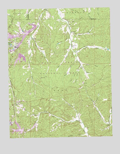
Viburnum East, MO USGS Topographic Map
Click on map above to begin viewing in our Map Viewer.

This topographic map contains these locations and features:
Feature Name Type Latitude Longitude GNIS ID View Map
Abbott BranchStreamN37.7084°W91.0451°748552View Map
Abbott CemeteryCemeteryN37.7103°W91.0337°748553View Map
Beasley HollowValleyN37.6956°W91.0349°748742View Map
BixbyPopulated PlaceN37.6603°W91.1151°748874View Map
Bramon HollowValleyN37.7003°W91.0415°748994View Map
Brooks CreekStreamN37.6359°W91.0024°749031View Map
Burt Iron BankMineN37.6823°W91.0065°736611View Map
Cave HollowValleyN37.7367°W91.0507°749263View Map
Chandler CemeteryCemeteryN37.6812°W91.1021°749325View Map
Clearwater Lake DamDamN37.6384°W91.0935°763899View Map
County Road DamDamN37.7184°W91.1085°764844View Map
Cove Iron BankMineN37.7070°W91.0515°736608View Map
Crocker CemeteryCemeteryN37.6923°W91.0354°749523View Map
East EndPopulated PlaceN37.6753°W91.0337°749769View Map
East Prong Indian CreekStreamN37.7239°W91.0965°749784View Map
Good WaterPopulated PlaceN37.7134°W91.0462°750071View Map
GoodlandPopulated PlaceN37.6362°W91.0018°750074View Map
Goodland School (historical)SchoolN37.6384°W91.0062°736612View Map
Goodwater School (historical)SchoolN37.7153°W91.0462°736609View Map
Gunstock HollowValleyN37.6270°W91.0321°750178View Map
Henderson CreekStreamN37.6400°W91.0401°750288View Map
Hickory Grove ChurchChurchN37.6828°W91.0851°750306View Map
Hickory HollowValleyN37.6350°W91.0026°750309View Map
Hoover HollowValleyN37.6895°W91.0407°750387View Map
Indian Creek ChurchChurchN37.7481°W91.0760°750456View Map
Intermediate Viburnum Tailings PondReservoirN37.7267°W91.1001°764843View Map
Left Fork Neals CreekStreamN37.6470°W91.0882°750682View Map
Low Gap HollowValleyN37.7278°W91.0515°750878View Map
Magmont Main Tailings LakeReservoirN37.6345°W91.1090°764748View Map
Magmont MineMineN37.6395°W91.1226°755558View Map
Magmont Mine Tailings DamDamN37.6317°W91.1085°764747View Map
Mark Twain National ForestForestN37.6794°W91.1144°729263View Map
Marques HollowValleyN37.6887°W91.0399°750941View Map
Mononame 812 DamDamN37.6800°W91.0318°763898View Map
Mononame 830 DamDamN37.6784°W91.0318°764780View Map
Neals Creek CemeteryCemeteryN37.6498°W91.0790°751268View Map
Neals Creek School (historical)SchoolN37.6437°W91.0635°747896View Map
New Viburnum Tailings DamDamN37.7050°W91.1068°765043View Map
New Viburnum Tailings PondReservoirN37.7050°W91.1068°765044View Map
Number 29 Mine Ore Haul Road North DamDamN37.7267°W91.1118°764846View Map
Number 29 Mine Ore Haul Road South DamDamN37.7167°W91.1218°764849View Map
Old Viburnum Tailings DamDamN37.7334°W91.0901°764076View Map
Old Viburnum Tailings PondReservoirN37.7340°W91.0885°764077View Map
Payne HollowValleyN37.7109°W91.0487°751516View Map
Pleasant Grove ChurchChurchN37.7214°W91.0951°751651View Map
Point Pleasant School (historical)SchoolN37.7223°W91.0960°747895View Map
Quad County Fire Protection District East End StationBuildingN37.6820°W91.0364°2620868View Map
Queen Mary PondReservoirN37.7267°W91.1118°764847View Map
Railroad Embankment DamDamN37.7234°W91.1168°765512View Map
Rogers Iron BankMineN37.6881°W91.0054°736607View Map
Saint Joe Shaft Thirty fiveMineN37.6592°W91.1237°755536View Map
Salem - Potosi Ranger DistrictsForestN37.6667°W91.0835°754434View Map
Thompson CemeteryCemeteryN37.6337°W91.0318°752529View Map
Township of DentCivilN37.6658°W91.0705°766794View Map
Turner CemeteryCemeteryN37.6453°W91.0437°752625View Map
Viburnum City Park LakeReservoirN37.7161°W91.1226°764850View Map
Viburnum MineMineN37.7134°W91.1157°752705View Map
Viburnum Tailings Dam Number 5DamN37.7234°W91.1201°764848View Map
Viburnum Tailings Disposal A ReservoirReservoirN37.7184°W91.1085°764845View Map
Viburnum Tailings Number 2 DamDamN37.7267°W91.1001°764842View Map
Walnut BranchStreamN37.7175°W91.0476°736606View Map
Warren HollowValleyN37.7262°W91.0474°752765View Map
West End SchoolSchoolN37.6720°W91.0374°752809View Map
West Prong Indian CreekStreamN37.7339°W91.0871°752827View Map
Wolf Pen HollowValleyN37.6570°W91.0207°752958View Map

Note: Coordinates in the location and feature list above are referenced to NAD83 datum.


Copyright (C) 2008-2024 Ryan Niemi / Sunset Dynamics ... All Rights Reserved