TopoQuest Logo
Do you find TopoQuest useful?
Help keep TopoQuest running and adding new maps/features by donating!
Bitcoin:  19c7KJd3qBynnjoSw5npx9KScwjBe4ifkT
Litecoin:  LXs6TkuXGGXo1vDsWCkWVdjQX94eUKd6ui
Home View Maps Find Maps Find Places Resources & Links


Greenville, Missouri Topographic Map

USGS Map Title: Greenville, MO
USGS Map MRC: 37090B4
DRG (GeoTIFF) Download: o37090b4.tif


Neighboring USGS Topographic Map Quads:


  Brunot, MO  
37090C5
 

  Coldwater, MO  
37090C4
 

  Cascade, MO  
37090C3
 

  Patterson, MO  
37090B5
 

  Greenville, MO  
37090B4
 

  Lowndes, MO  
37090B3
 

  Piedmont SE, MO  
37090A5
 

  Greenville SW, MO  
37090A4
 

  Shook, MO  
37090A3


Map MRC Location:

N38°
W91°
N38°
W90°
H8 H7 H6 H5 H4 H3 H2 H1
G8 G7 G6 G5 G4 G3 G2 G1
F8 F7 F6 F5 F4 F3 F2 F1
E8 E7 E6 E5 E4 E3 E2 E1
D8 D7 D6 D5 D4 D3 D2 D1
C8 C7 C6 C5 C4 C3 C2 C1
B8 B7 B6 B5 B4 B3 B2 B1
A8 A7 A6 A5 A4 A3 A2 A1
N37°
W91°
N37°
W90°

Greenville, MO USGS 1:24K Topographic Map Preview:
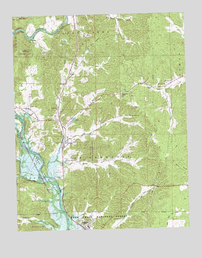
Greenville, MO USGS Topographic Map
Click on map above to begin viewing in our Map Viewer.

This topographic map contains these locations and features:
Feature Name Type Latitude Longitude GNIS ID View Map
Bennett CemeteryCemeteryN37.1662°W90.4621°748785View Map
Bennett CemeteryCemeteryN37.2464°W90.4232°748786View Map
BoundsPopulated PlaceN37.2106°W90.4626°748973View Map
Bounds CreekStreamN37.1659°W90.4709°748975View Map
Camp LewallenLocaleN37.2351°W90.4873°749180View Map
City of GreenvilleCivilN37.1284°W90.4472°2394997View Map
Clark CemeteryCemeteryN37.1300°W90.3876°749366View Map
Clark CreekStreamN37.1809°W90.4973°749368View Map
Frazier CreekStreamN37.1731°W90.4673°749984View Map
Granny BranchStreamN37.1648°W90.3893°730509View Map
GreenvillePopulated PlaceN37.1273°W90.4501°750153View Map
Greenville Police DepartmentBuildingN37.1266°W90.4511°2752589View Map
Greenville Post OfficePost OfficeN37.1263°W90.4504°2783055View Map
Hubble CreekStreamN37.1564°W90.4768°750410View Map
Hunters Tourist CampLocaleN37.2208°W90.4664°730508View Map
Kelly FordLocaleN37.2498°W90.4604°748004View Map
Kelly HillSummitN37.1331°W90.4629°730507View Map
Lake PotashnikReservoirN37.2301°W90.4801°764395View Map
Lake Potashnik DamDamN37.2301°W90.4801°764394View Map
Lake Wappapella State Wildlife Management AreaParkN37.1667°W90.4796°754091View Map
Little Lake Creek School (historical)SchoolN37.1323°W90.4921°748006View Map
Logan MountainSummitN37.2301°W90.4943°750822View Map
Missionary AcresPopulated PlaceN37.2042°W90.4209°751127View Map
Montgomery ChurchChurchN37.1967°W90.4684°751142View Map
Mount Pisgah ChurchChurchN37.2156°W90.4584°751188View Map
New Liberty ChurchChurchN37.1909°W90.4146°751299View Map
New Prospect ChurchChurchN37.1653°W90.4590°751302View Map
New Prospect School (historical)SchoolN37.2092°W90.4576°730510View Map
Peters BranchStreamN37.1823°W90.4659°751569View Map
Roach HollowValleyN37.2292°W90.4457°751903View Map
Rockwell CemeteryCemeteryN37.1334°W90.4965°751933View Map
SilvaPopulated PlaceN37.1762°W90.4637°752158View Map
Silva Post OfficePost OfficeN37.1750°W90.4641°2782987View Map
Silva Post Office (historical)Post OfficeN37.1651°W90.4654°760139View Map
Silva School (historical)SchoolN37.1656°W90.4490°748005View Map
Silva State Wildlife Management AreaParkN37.1720°W90.4448°753458View Map
Twidwell CemeteryCemeteryN37.2206°W90.4532°752639View Map
Union ChurchChurchN37.1806°W90.4462°752656View Map
Union Grove ChurchChurchN37.1309°W90.4251°752661View Map
Vavak CemeteryCemeteryN37.2142°W90.4498°752699View Map
Wayne County Sheriff's OfficeBuildingN37.1276°W90.4514°2752287View Map
Wayne County Volunteer Fire Protection DistrictBuildingN37.1251°W90.4521°2621407View Map
Wet HollowValleyN37.2478°W90.4248°753602View Map
White HollowValleyN37.2053°W90.3909°752850View Map
White Hollow CemeteryCemeteryN37.1639°W90.3848°730506View Map
White Hollow ChurchChurchN37.2106°W90.3851°752852View Map
White Hollow SchoolSchoolN37.2087°W90.3898°752853View Map

Note: Coordinates in the location and feature list above are referenced to NAD83 datum.


Copyright (C) 2008-2025 Ryan Niemi / Sunset Dynamics ... All Rights Reserved