TopoQuest Logo
Do you find TopoQuest useful?
Help keep TopoQuest running and adding new maps/features by donating!
Bitcoin:  19c7KJd3qBynnjoSw5npx9KScwjBe4ifkT
Litecoin:  LXs6TkuXGGXo1vDsWCkWVdjQX94eUKd6ui
Home View Maps Find Maps Find Places Resources & Links


Lowndes, Missouri Topographic Map

USGS Map Title: Lowndes, MO
USGS Map MRC: 37090B3
DRG (GeoTIFF) Download: o37090b3.tif


Neighboring USGS Topographic Map Quads:


  Coldwater, MO  
37090C4
 

  Cascade, MO  
37090C3
 

  Allbright, MO  
37090C2
 

  Greenville, MO  
37090B4
 

  Lowndes, MO  
37090B3
 

  Gipsy, MO  
37090B2
 

  Greenville SW, MO  
37090A4
 

  Shook, MO  
37090A3
 

  McGee, MO  
37090A2


Map MRC Location:

N38°
W91°
N38°
W90°
H8 H7 H6 H5 H4 H3 H2 H1
G8 G7 G6 G5 G4 G3 G2 G1
F8 F7 F6 F5 F4 F3 F2 F1
E8 E7 E6 E5 E4 E3 E2 E1
D8 D7 D6 D5 D4 D3 D2 D1
C8 C7 C6 C5 C4 C3 C2 C1
B8 B7 B6 B5 B4 B3 B2 B1
A8 A7 A6 A5 A4 A3 A2 A1
N37°
W91°
N37°
W90°

Lowndes, MO USGS 1:24K Topographic Map Preview:
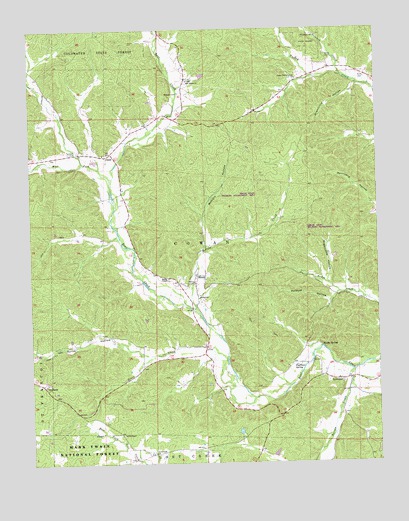
Lowndes, MO USGS Topographic Map
Click on map above to begin viewing in our Map Viewer.

This topographic map contains these locations and features:
Feature Name Type Latitude Longitude GNIS ID View Map
Anderson LakeReservoirN37.1267°W90.2884°765165View Map
Anderson Lake DamDamN37.1267°W90.2884°765164View Map
Andy Jack HollowValleyN37.2351°W90.2601°753547View Map
Barnes CreekStreamN37.1514°W90.2593°748679View Map
BurbankPopulated PlaceN37.1470°W90.3704°749114View Map
Burbank School (historical)SchoolN37.1576°W90.3668°748007View Map
Byron HollowValleyN37.1562°W90.3346°749149View Map
Camp Number 30LocaleN37.1526°W90.3326°730503View Map
ClubbPopulated PlaceN37.2145°W90.3457°749390View Map
Clubb SchoolSchoolN37.1612°W90.3487°730504View Map
Coldwater State ForestForestN37.2417°W90.3454°749410View Map
Crossroads ChurchChurchN37.1278°W90.3312°749537View Map
Faulkner SpringSpringN37.1529°W90.2803°749904View Map
Gizzard CreekStreamN37.2351°W90.2601°750046View Map
Goose CreekStreamN37.1542°W90.3048°750076View Map
Graham CemeteryCemeteryN37.2314°W90.3209°750098View Map
Greenville HollowValleyN37.2334°W90.2571°750156View Map
Hickory Grove ChurchChurchN37.1609°W90.3471°730502View Map
HiramPopulated PlaceN37.1789°W90.3148°750341View Map
Hiram SchoolSchoolN37.1726°W90.3146°750342View Map
Hiram State Wildlife Management AreaParkN37.1937°W90.2796°753459View Map
Holmes Chapel (historical)ChurchN37.1334°W90.3523°1669627View Map
Holmes Chapel School (historical)SchoolN37.1334°W90.3523°766192View Map
Hughs SpringSpringN37.1588°W90.2707°750417View Map
LowndesPopulated PlaceN37.1489°W90.2634°750889View Map
Lowndes CemeteryCemeteryN37.2270°W90.2637°730505View Map
Lowndes Post OfficePost OfficeN37.1487°W90.2640°2782868View Map
Lowndes Volunteer Fire and RescueBuildingN37.1495°W90.2710°2621013View Map
McCabe CreekStreamN37.1667°W90.3134°750980View Map
McCarn HollowValleyN37.1753°W90.3162°750983View Map
New Home ChurchChurchN37.2351°W90.3176°751288View Map
Perkins HollowValleyN37.2392°W90.3259°753549View Map
Polecat HollowValleyN37.1734°W90.2654°751688View Map
Sugarcamp HollowValleyN37.1778°W90.2676°752419View Map
Thirtyone HollowValleyN37.2362°W90.2734°753548View Map
Township of CowanCivilN37.1929°W90.3022°767519View Map
Twidwell CemeteryCemeteryN37.2145°W90.3607°752638View Map
Upper Turkey Creek ChurchChurchN37.2356°W90.2784°752680View Map
Upper Turkey Creek School (historical)SchoolN37.2367°W90.2673°748008View Map
Ward CemeteryCemeteryN37.2353°W90.2540°752756View Map
Ward CemeteryCemeteryN37.2417°W90.2673°752757View Map
Wesley ChapelChurchN37.1781°W90.3254°752805View Map
West Fork Bear CreekStreamN37.2064°W90.3462°752812View Map
Williams Lake Section 31ReservoirN37.2366°W90.3126°764920View Map
Williams Lake Section 31 DamDamN37.2351°W90.3134°764919View Map

Note: Coordinates in the location and feature list above are referenced to NAD83 datum.


Copyright (C) 2008-2025 Ryan Niemi / Sunset Dynamics ... All Rights Reserved