TopoQuest Logo
Do you find TopoQuest useful?
Help keep TopoQuest running and adding new maps/features by donating!
Bitcoin:  19c7KJd3qBynnjoSw5npx9KScwjBe4ifkT
Litecoin:  LXs6TkuXGGXo1vDsWCkWVdjQX94eUKd6ui
Home View Maps Find Maps Find Places Resources & Links


Coldwater, Missouri Topographic Map

USGS Map Title: Coldwater, MO
USGS Map MRC: 37090C4
DRG (GeoTIFF) Download: o37090c4.tif


Neighboring USGS Topographic Map Quads:


  Des Arc NE, MO  
37090D5
 

  Rock Pile Mountain, MO  
37090D4
 

  Cherokee Pass, MO  
37090D3
 

  Brunot, MO  
37090C5
 

  Coldwater, MO  
37090C4
 

  Cascade, MO  
37090C3
 

  Patterson, MO  
37090B5
 

  Greenville, MO  
37090B4
 

  Lowndes, MO  
37090B3


Map MRC Location:

N38°
W91°
N38°
W90°
H8 H7 H6 H5 H4 H3 H2 H1
G8 G7 G6 G5 G4 G3 G2 G1
F8 F7 F6 F5 F4 F3 F2 F1
E8 E7 E6 E5 E4 E3 E2 E1
D8 D7 D6 D5 D4 D3 D2 D1
C8 C7 C6 C5 C4 C3 C2 C1
B8 B7 B6 B5 B4 B3 B2 B1
A8 A7 A6 A5 A4 A3 A2 A1
N37°
W91°
N37°
W90°

Coldwater, MO USGS 1:24K Topographic Map Preview:
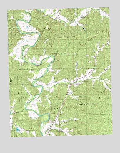
Coldwater, MO USGS Topographic Map
Click on map above to begin viewing in our Map Viewer.

This topographic map contains these locations and features:
Feature Name Type Latitude Longitude GNIS ID View Map
Adams HollowValleyN37.3053°W90.3904°738422View Map
Antioch CemeteryCemeteryN37.2512°W90.4540°743060View Map
Antioch Church (historical)ChurchN37.2517°W90.4540°730462View Map
Bald KnobSummitN37.3245°W90.4421°713587View Map
Bennett CreekStreamN37.2532°W90.4617°748787View Map
Bill Goad HollowValleyN37.2978°W90.3807°738490View Map
Camp Number 26LocaleN37.2509°W90.4523°730461View Map
Cedar CreekStreamN37.2964°W90.4598°715585View Map
Cherokee Ridge CampLocaleN37.2562°W90.4893°743061View Map
Cold Water HillsRangeN37.2812°W90.4354°730460View Map
ColdwaterPopulated PlaceN37.3034°W90.4098°716084View Map
Coldwater SpringSpringN37.3030°W90.4094°738493View Map
Collier CreekStreamN37.2820°W90.4798°716125View Map
Collins LakeReservoirN37.2737°W90.4996°764034View Map
Coon CreekStreamN37.3034°W90.4159°716241View Map
Dorsey HollowValleyN37.3037°W90.3829°738491View Map
Dryer HollowValleyN37.3306°W90.4301°717137View Map
Firebaugh HollowValleyN37.3642°W90.4890°738475View Map
Gray MountainSummitN37.2895°W90.4890°738486View Map
Greenwood BranchStreamN37.3051°W90.4032°738453View Map
Greenwood CemeteryCemeteryN37.3237°W90.3948°743055View Map
Gregory HollowValleyN37.3048°W90.4004°738492View Map
Head Ford (historical)Populated PlaceN37.3062°W90.4659°740918View Map
Hunter CreekStreamN37.2642°W90.4557°720015View Map
Huzzah CanyonValleyN37.3284°W90.4443°738485View Map
Huzzah CreekStreamN37.3281°W90.4440°720053View Map
Jordon HollowValleyN37.2923°W90.4257°738494View Map
Lewis CemeteryCemeteryN37.2603°W90.4504°743059View Map
Linville-Barrett CemeteryCemeteryN37.3095°W90.4034°743063View Map
LodiPopulated PlaceN37.2564°W90.4529°721401View Map
Lodi Nazarene ChurchChurchN37.2553°W90.4537°730459View Map
Marsh Ford (historical)LocaleN37.3739°W90.4546°741720View Map
Mitchell HollowValleyN37.2520°W90.4326°738497View Map
Mount GlorySummitN37.2728°W90.4451°738488View Map
New Home ChurchChurchN37.3667°W90.4382°743052View Map
Oak Dale ChurchChurchN37.3314°W90.3898°743054View Map
Otahki LakeReservoirN37.2576°W90.4912°763713View Map
Otahki Lake DamDamN37.2567°W90.4918°763712View Map
Paullus CemeteryCemeteryN37.3017°W90.4140°743062View Map
Paullus SchoolSchoolN37.3020°W90.4509°724108View Map
Philis HollowValleyN37.2876°W90.4190°738495View Map
Ray HollowValleyN37.3598°W90.4296°738479View Map
Reed BendBendN37.3237°W90.4798°738482View Map
Reed Bend Ford (historical)LocaleN37.3234°W90.4768°725180View Map
Reed Bend SchoolSchoolN37.3273°W90.4640°725181View Map
Rocky Grove ChurchChurchN37.2745°W90.4934°743057View Map
Rowland SchoolSchoolN37.2570°W90.4815°725640View Map
SacoPopulated PlaceN37.3656°W90.4393°741222View Map
Seabaugh HollowValleyN37.3570°W90.4876°738476View Map
Shafer HollowValleyN37.3617°W90.4221°738480View Map
Shelton FordPopulated PlaceN37.3514°W90.4793°741262View Map
Short CemeteryCemeteryN37.3020°W90.4412°743056View Map
Spout SpringSpringN37.3423°W90.4891°738481View Map
Squaw HollowValleyN37.3395°W90.4548°738483View Map
Stillhouse SpringSpringN37.3532°W90.4620°738477View Map
Strahl MountainSummitN37.2873°W90.4437°738487View Map
Sutton CemeteryCemeteryN37.2637°W90.4448°743058View Map
Tater HillSummitN37.2512°W90.4940°727475View Map
Township of Cedar CreekCivilN37.2807°W90.4053°767518View Map
Township of TwelvemileCivilN37.3661°W90.3958°766991View Map
Trace CreekStreamN37.3687°W90.4493°752570View Map
Turkey RidgeRidgeN37.3412°W90.4443°738484View Map
Twelvemile CreekStreamN37.3723°W90.4565°752635View Map
Varsh FordPopulated PlaceN37.3739°W90.4543°741335View Map
Victoria MountainSummitN37.2612°W90.4654°738489View Map
Wakefield HollowValleyN37.2931°W90.4282°738496View Map
Whitaker HillSummitN37.3564°W90.4526°738478View Map
Whitener CemeteryCemeteryN37.3667°W90.4082°743053View Map
Wilkinson MountainSummitN37.2973°W90.4134°730458View Map
Wilmore CreekStreamN37.3014°W90.4318°730020View Map

Note: Coordinates in the location and feature list above are referenced to NAD83 datum.


Copyright (C) 2008-2025 Ryan Niemi / Sunset Dynamics ... All Rights Reserved