TopoQuest Logo
Do you find TopoQuest useful?
Help keep TopoQuest running and adding new maps/features by donating!
Bitcoin:  19c7KJd3qBynnjoSw5npx9KScwjBe4ifkT
Litecoin:  LXs6TkuXGGXo1vDsWCkWVdjQX94eUKd6ui
Home View Maps Find Maps Find Places Resources & Links


Normal West, Illinois Topographic Map

USGS Map Title: Normal West, IL
USGS Map MRC: 40089E1
DRG (GeoTIFF) Download: o40089e1.tif


Neighboring USGS Topographic Map Quads:


  Secor, IL  
40089F2
 

  El Paso, IL  
40089F1
 

  Gridley, IL  
40088F8
 

  Danvers, IL  
40089E2
 

  Normal West, IL  
40089E1
 

  Normal East, IL  
40088E8
 

  Stanford, IL  
40089D2
 

  Bloomington West, IL  
40089D1
 

  Bloomington East, IL  
40088D8


Map MRC Location:

N41°
W90°
N41°
W89°
H8 H7 H6 H5 H4 H3 H2 H1
G8 G7 G6 G5 G4 G3 G2 G1
F8 F7 F6 F5 F4 F3 F2 F1
E8 E7 E6 E5 E4 E3 E2 E1
D8 D7 D6 D5 D4 D3 D2 D1
C8 C7 C6 C5 C4 C3 C2 C1
B8 B7 B6 B5 B4 B3 B2 B1
A8 A7 A6 A5 A4 A3 A2 A1
N40°
W90°
N40°
W89°

Normal West, IL USGS 1:24K Topographic Map Preview:
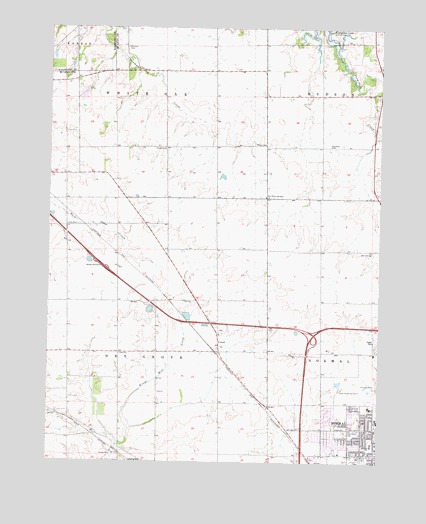
Normal West, IL USGS Topographic Map
Click on map above to begin viewing in our Map Viewer.

This topographic map contains these locations and features:
Feature Name Type Latitude Longitude GNIS ID View Map
Belvidere School (historical)SchoolN40.5225°W89.0595°1747533View Map
Center School (historical)SchoolN40.5323°W89.0837°1747546View Map
Crown Point School (historical)SchoolN40.5900°W89.1004°1747552View Map
Dearing Country FarmsLocaleN40.5225°W89.1192°2566242View Map
Denman CemeteryCemeteryN40.6195°W89.0964°407122View Map
Denman School (historical)SchoolN40.6128°W89.0987°1747556View Map
Dry Grove School (historical)SchoolN40.5148°W89.1212°1747559View Map
Dry Grove TownhallBuildingN40.5311°W89.0981°1747560View Map
East White Oak Bible ChurchChurchN40.5764°W89.0431°407710View Map
Eyestone School MuseumBuildingN40.5106°W89.0012°1822461View Map
Fairview ParkParkN40.5231°W89.0009°408207View Map
Garfield School (historical)SchoolN40.5614°W89.0612°1747574View Map
Grace Baptist ChurchChurchN40.5017°W89.0076°1822477View Map
Grant School (historical)SchoolN40.5461°W89.1195°1747577View Map
Heartland Community CollegeSchoolN40.5336°W89.0137°2041382View Map
Holder School (historical)SchoolN40.6056°W89.0220°1747585View Map
Holy Cross CemeteryCemeteryN40.5089°W89.0126°410428View Map
Illinois State University Golf CourseLocaleN40.5184°W89.0040°1822503View Map
Interchange 125CrossingN40.5400°W89.0637°1822505View Map
Interchange 127CrossingN40.5361°W89.0254°1822506View Map
Interchange 163CrossingN40.5361°W89.0254°1822515View Map
Kaufman CemeteryCemeteryN40.5906°W89.0193°411328View Map
Kaufman School (historical)SchoolN40.5906°W89.0226°1747595View Map
Lantz CemeteryCemeteryN40.5681°W89.1142°411823View Map
Linkins CenterBuildingN40.5123°W89.0006°1822532View Map
Maple Grove School (historical)SchoolN40.5911°W89.0620°1747602View Map
Maxwell ParkParkN40.5161°W89.0226°1822539View Map
Mitsubishi Fire BrigadeBuildingN40.5049°W89.0592°2682630View Map
Normal Community High SchoolSchoolN40.5228°W89.0231°2041383View Map
Normal Fire Department Station 2BuildingN40.5177°W89.0012°2041385View Map
Normal Industrial ParkLocaleN40.5006°W89.0215°1822560View Map
Northmeadow Village Trailer ParkPopulated PlaceN40.5353°W89.0006°1822562View Map
Oakdale Elementary SchoolSchoolN40.5050°W89.0026°414879View Map
Oasis Trailer ParkPopulated PlaceN40.5011°W89.0062°1822565View Map
Parkside Elementary SchoolSchoolN40.5106°W89.0240°2041387View Map
Parkside Junior High SchoolSchoolN40.5120°W89.0229°1822572View Map
Pickett School (historical)SchoolN40.5320°W89.0212°1747618View Map
Ropp CemeteryCemeteryN40.5917°W89.0477°416930View Map
Ropp FarmsLocaleN40.5572°W89.0414°2628343View Map
Rose Hill School (historical)SchoolN40.5023°W89.0212°1747622View Map
Schlipf LakeReservoirN40.6175°W89.1162°1691384View Map
Schlipf Lake DamDamN40.6200°W89.1101°1691383View Map
State University FarmLocaleN40.5214°W89.0140°1747634View Map
Sunset LakeReservoirN40.6063°W89.1120°1692307View Map
Sunset Lake Subdivision DamDamN40.6084°W89.1101°1692306View Map
Township of Dry GroveCivilN40.5318°W89.0980°428913View Map
Township of White OakCivilN40.5977°W89.0913°429930View Map
Troyer CemeteryCemeteryN40.5901°W89.0813°419902View Map
University Park Plaza Shopping CenterLocaleN40.5103°W89.0179°1822606View Map
West Point School (historical)SchoolN40.5614°W89.0220°1747645View Map
WGLT-FM (Normal)TowerN40.5092°W89.0001°428258View Map
White Oak School (historical)SchoolN40.6123°W89.0623°1747648View Map
Wilkins HallBuildingN40.5120°W89.0004°1822621View Map
Wright HallBuildingN40.5128°W89.0006°1822696View Map
YutonPopulated PlaceN40.5334°W89.0604°423345View Map

Note: Coordinates in the location and feature list above are referenced to NAD83 datum.


Copyright (C) 2008-2024 Ryan Niemi / Sunset Dynamics ... All Rights Reserved