TopoQuest Logo
Do you find TopoQuest useful?
Help keep TopoQuest running and adding new maps/features by donating!
Bitcoin:  19c7KJd3qBynnjoSw5npx9KScwjBe4ifkT
Litecoin:  LXs6TkuXGGXo1vDsWCkWVdjQX94eUKd6ui
Home View Maps Find Maps Find Places Resources & Links


Ousley, Georgia Topographic Map

USGS Map Title: Ousley, GA
USGS Map MRC: 30083G4
DRG (GeoTIFF) Download: o30083g4.tif


Neighboring USGS Topographic Map Quads:


  Pebble Hill, GA  
30083H5
 

  Hahira West, GA  
30083H4
 

  Hahira East, GA  
30083H3
 

  Quitman, GA  
30083G5
 

  Ousley, GA  
30083G4
 

  Valdosta, GA  
30083G3
 

  Baden, GA  
30083F5
 

  Nankin, GA  
30083F4
 

  Clyattville, GA  
30083F3


Map MRC Location:

N31°
W84°
N31°
W83°
H8 H7 H6 H5 H4 H3 H2 H1
G8 G7 G6 G5 G4 G3 G2 G1
F8 F7 F6 F5 F4 F3 F2 F1
E8 E7 E6 E5 E4 E3 E2 E1
D8 D7 D6 D5 D4 D3 D2 D1
C8 C7 C6 C5 C4 C3 C2 C1
B8 B7 B6 B5 B4 B3 B2 B1
A8 A7 A6 A5 A4 A3 A2 A1
N30°
W84°
N30°
W83°

Ousley, GA USGS 1:24K Topographic Map Preview:
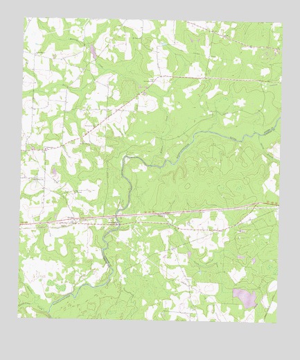
Ousley, GA USGS Topographic Map
Click on map above to begin viewing in our Map Viewer.

This topographic map contains these locations and features:
Feature Name Type Latitude Longitude GNIS ID View Map
Blue SpringsPopulated PlaceN30.7899°W83.4565°354787View Map
Chappell LakeReservoirN30.8595°W83.4654°341703View Map
Chappell Lake DamDamN30.8585°W83.4632°341702View Map
DurdenPopulated PlaceN30.7919°W83.4735°331605View Map
East Brooks Volunteer Fire DepartmentBuildingN30.8701°W83.4080°2604657View Map
Gates (historical)Populated PlaceN30.8605°W83.4102°345544View Map
Gateway ChurchChurchN30.8652°W83.3838°345545View Map
Golden (historical)Populated PlaceN30.8699°W83.4429°345547View Map
Langdale Company DamDamN30.7502°W83.4915°341700View Map
Langdale LakeReservoirN30.7611°W83.3893°340873View Map
Langdale Lake DamDamN30.7619°W83.3965°340872View Map
Lebanon CemeteryCemeteryN30.8074°W83.4924°345562View Map
Lebanon ChurchChurchN30.8080°W83.4924°316716View Map
Millrace CreekStreamN30.8149°W83.4377°318282View Map
Morning Star ChurchChurchN30.8033°W83.4740°318472View Map
Mount Pleasant ChurchChurchN30.8677°W83.4429°318826View Map
Oak Grove ChurchChurchN30.8499°W83.4377°319757View Map
Oakhill School (historical)SchoolN30.8196°W83.4882°345578View Map
Okapilco CreekStreamN30.7527°W83.4852°319931View Map
OusleyPopulated PlaceN30.7944°W83.4307°332583View Map
Ousley ChurchChurchN30.7899°W83.4282°346318View Map
Ousley ChurchChurchN30.7913°W83.4282°346319View Map
Philadelphia ChurchChurchN30.8205°W83.4882°320428View Map
Pine Grove School (historical)SchoolN30.8519°W83.4718°345586View Map
Piscola CreekStreamN30.7566°W83.4924°320751View Map
Pleasant Hill ChurchChurchN30.8233°W83.4671°320862View Map
Primrose Church (historical)ChurchN30.8521°W83.4260°345591View Map
Richardson Creek ChurchChurchN30.8599°W83.4940°321571View Map
Spring BranchStreamN30.8280°W83.3854°323369View Map
Tiger CreekStreamN30.7883°W83.4521°324166View Map
WAFT-FM (Valdosta)TowerN30.8641°W83.3940°352811View Map
Welcome Hill ChurchChurchN30.8305°W83.4649°324983View Map
West Side Volunteer Fire DepartmentBuildingN30.7880°W83.4115°2604049View Map

Note: Coordinates in the location and feature list above are referenced to NAD83 datum.


Copyright (C) 2008-2025 Ryan Niemi / Sunset Dynamics ... All Rights Reserved