TopoQuest Logo
Do you find TopoQuest useful?
Help keep TopoQuest running and adding new maps/features by donating!
Bitcoin:  19c7KJd3qBynnjoSw5npx9KScwjBe4ifkT
Litecoin:  LXs6TkuXGGXo1vDsWCkWVdjQX94eUKd6ui
Home View Maps Find Maps Find Places Resources & Links


Hahira West, Georgia Topographic Map

USGS Map Title: Hahira West, GA
USGS Map MRC: 30083H4
DRG (GeoTIFF) Download: o30083h4.tif


Neighboring USGS Topographic Map Quads:


  Berlin East, GA  
31083A5
 

  Cecil, GA  
31083A4
 

  New Lois, GA  
31083A3
 

  Pebble Hill, GA  
30083H5
 

  Hahira West, GA  
30083H4
 

  Hahira East, GA  
30083H3
 

  Quitman, GA  
30083G5
 

  Ousley, GA  
30083G4
 

  Valdosta, GA  
30083G3


Map MRC Location:

N31°
W84°
N31°
W83°
H8 H7 H6 H5 H4 H3 H2 H1
G8 G7 G6 G5 G4 G3 G2 G1
F8 F7 F6 F5 F4 F3 F2 F1
E8 E7 E6 E5 E4 E3 E2 E1
D8 D7 D6 D5 D4 D3 D2 D1
C8 C7 C6 C5 C4 C3 C2 C1
B8 B7 B6 B5 B4 B3 B2 B1
A8 A7 A6 A5 A4 A3 A2 A1
N30°
W84°
N30°
W83°

Hahira West, GA USGS 1:24K Topographic Map Preview:
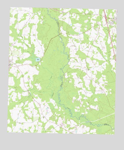
Hahira West, GA USGS Topographic Map
Click on map above to begin viewing in our Map Viewer.

This topographic map contains these locations and features:
Feature Name Type Latitude Longitude GNIS ID View Map
Big CreekStreamN30.9494°W83.3835°311357View Map
City of HahiraCivilN30.9942°W83.3787°2403780View Map
Corinth CemeteryCemeteryN30.9460°W83.4638°312975View Map
Corinth Church (historical)ChurchN30.9457°W83.4635°345532View Map
Downing CreekStreamN30.9127°W83.4485°313606View Map
Elizabeth Church (historical)ChurchN30.8852°W83.4854°345537View Map
Exit 7CrossingN30.9921°W83.3882°1672941View Map
Friendship ChurchChurchN30.9733°W83.3782°314391View Map
Hall CemeteryCemeteryN30.9644°W83.4943°315032View Map
Jones CreekStreamN30.9169°W83.4671°316230View Map
Lawson PondReservoirN30.9486°W83.4657°316702View Map
Lawson Pond Dam Number 2DamN30.9469°W83.4632°341953View Map
Lawson Pond Dam Number OneDamN30.9485°W83.4632°338379View Map
Miller BridgeBridgeN30.9732°W83.4424°346299View Map
Miller CemeteryCemeteryN30.9760°W83.4310°318255View Map
MorvenPopulated PlaceN30.9416°W83.4993°318505View Map
Morven Baptist ChurchChurchN30.9402°W83.4990°345568View Map
Morven DivisionCivilN30.9036°W83.4975°1936420View Map
Morven Elementary SchoolSchoolN30.9427°W83.4982°345569View Map
Morven Police DepartmentBuildingN30.9432°W83.4982°2733715View Map
Morven Post OfficePost OfficeN30.9435°W83.4992°345570View Map
Mount Zion ChurchChurchN30.9607°W83.4993°318934View Map
Paso Fino Farm AirportAirportN30.8803°W83.4144°351938View Map
Pauline ChurchChurchN30.8913°W83.4571°320283View Map
Pike BranchStreamN30.9546°W83.4715°320512View Map
Pineview ChurchChurchN30.9202°W83.4135°320673View Map
Providence ChurchChurchN30.8763°W83.4249°321184View Map
Redding CemeteryCemeteryN30.9419°W83.4346°346386View Map
Rizer CemeteryCemeteryN30.8946°W83.4593°321660View Map
Second Elizabeth ChurchChurchN30.8849°W83.4860°322692View Map
Shilo Farms AirportAirportN30.9355°W83.3835°351785View Map
ShilohPopulated PlaceN30.9402°W83.4077°333033View Map
Shiloh ChurchChurchN30.9385°W83.4079°346346View Map
Shiloh Volunteer Fire Department Station 6BuildingN30.9394°W83.4085°2604474View Map
Slaughter CreekStreamN30.9049°W83.4402°323075View Map
Tillman (historical)Populated PlaceN30.8899°W83.4621°345619View Map
Tucker Bridge (historical)BridgeN30.9260°W83.4368°346357View Map
Webb-Miller SchoolSchoolN30.9866°W83.3810°324960View Map

Note: Coordinates in the location and feature list above are referenced to NAD83 datum.


Copyright (C) 2008-2024 Ryan Niemi / Sunset Dynamics ... All Rights Reserved