TopoQuest Logo
Do you find TopoQuest useful?
Help keep TopoQuest running and adding new maps/features by donating!
Bitcoin:  19c7KJd3qBynnjoSw5npx9KScwjBe4ifkT
Litecoin:  LXs6TkuXGGXo1vDsWCkWVdjQX94eUKd6ui
Home View Maps Find Maps Find Places Resources & Links


Pebble Hill, Georgia Topographic Map

USGS Map Title: Pebble Hill, GA
USGS Map MRC: 30083H5
DRG (GeoTIFF) Download: o30083h5.tif


Neighboring USGS Topographic Map Quads:


  Berlin West, GA  
31083A6
 

  Berlin East, GA  
31083A5
 

  Cecil, GA  
31083A4
 

  Pavo, GA  
30083H6
 

  Pebble Hill, GA  
30083H5
 

  Hahira West, GA  
30083H4
 

  Dixie, GA  
30083G6
 

  Quitman, GA  
30083G5
 

  Ousley, GA  
30083G4


Map MRC Location:

N31°
W84°
N31°
W83°
H8 H7 H6 H5 H4 H3 H2 H1
G8 G7 G6 G5 G4 G3 G2 G1
F8 F7 F6 F5 F4 F3 F2 F1
E8 E7 E6 E5 E4 E3 E2 E1
D8 D7 D6 D5 D4 D3 D2 D1
C8 C7 C6 C5 C4 C3 C2 C1
B8 B7 B6 B5 B4 B3 B2 B1
A8 A7 A6 A5 A4 A3 A2 A1
N30°
W84°
N30°
W83°

Pebble Hill, GA USGS 1:24K Topographic Map Preview:
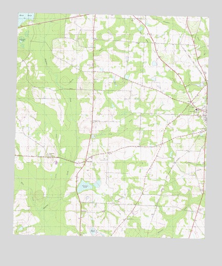
Pebble Hill, GA USGS Topographic Map
Click on map above to begin viewing in our Map Viewer.

This topographic map contains these locations and features:
Feature Name Type Latitude Longitude GNIS ID View Map
Antioch ChurchChurchN30.8894°W83.5804°310561View Map
Bay BranchStreamN30.9794°W83.5016°310875View Map
Brice Mill (historical)LocaleN30.9960°W83.6146°345517View Map
Central School (historical)SchoolN30.9296°W83.6152°345526View Map
City of MorvenCivilN30.9433°W83.5003°2404311View Map
Crevasse PondReservoirN30.9031°W83.5791°313113View Map
Dellinory ChurchChurchN30.9499°W83.5010°313436View Map
Gum CreekStreamN30.9299°W83.5832°314961View Map
Johnson PondLakeN30.9826°W83.6217°316179View Map
Kennedy (historical)Populated PlaceN30.9177°W83.5199°345559View Map
Kennedy CemeteryCemeteryN30.9202°W83.6027°345560View Map
Kennedy HillSummitN30.9210°W83.6027°332138View Map
Little CreekStreamN30.9007°W83.6018°317018View Map
McMillian LakeReservoirN30.9024°W83.5107°340839View Map
McMillian Lake DamDamN30.9019°W83.5099°340838View Map
Moore Lake DamDamN30.8785°W83.5749°340836View Map
Moore PondReservoirN30.8781°W83.5728°318441View Map
Morrison ChurchChurchN30.9716°W83.5749°318498View Map
Morven - North Brooks Fire DepartmentBuildingN30.9413°W83.5004°2604300View Map
Morven Primary SchoolSchoolN30.9480°W83.5071°345571View Map
Mount Horeb CemeteryCemeteryN30.8919°W83.5040°318672View Map
Mount Horeb Church (historical)ChurchN30.8921°W83.5040°334800View Map
Mule CreekStreamN30.8907°W83.6096°319140View Map
New Hope ChurchChurchN30.9491°W83.5085°319360View Map
New Macedonia ChurchChurchN30.8857°W83.5507°319474View Map
Northeast Brooks Division (historical)CensusN30.9830°W83.5271°1936440View Map
Pebble HillPopulated PlaceN30.9174°W83.5779°332628View Map
Pine View CemeteryCemeteryN30.9024°W83.5004°320651View Map
Rainy CreekStreamN30.9599°W83.5896°321290View Map
Robinson ChurchChurchN30.9849°W83.5446°321691View Map
Saint James ChurchChurchN30.9402°W83.5713°322073View Map
Saint Pauls ChurchChurchN30.9221°W83.5635°322243View Map
Salem ChurchChurchN30.9863°W83.5724°322337View Map
Siloam ChurchChurchN30.9469°W83.5082°322978View Map
Tallokas (historical)Populated PlaceN30.9935°W83.6152°345616View Map
Union ChurchChurchN30.9635°W83.5738°324503View Map

Note: Coordinates in the location and feature list above are referenced to NAD83 datum.


Copyright (C) 2008-2025 Ryan Niemi / Sunset Dynamics ... All Rights Reserved