TopoQuest Logo
Do you find TopoQuest useful?
Help keep TopoQuest running and adding new maps/features by donating!
Bitcoin:  19c7KJd3qBynnjoSw5npx9KScwjBe4ifkT
Litecoin:  LXs6TkuXGGXo1vDsWCkWVdjQX94eUKd6ui
Home View Maps Find Maps Find Places Resources & Links


Hainesville, Texas Topographic Map

USGS Map Title: Hainesville, TX
USGS Map MRC: 32095F3
DRG (GeoTIFF) Download: o32095f3.tif


Neighboring USGS Topographic Map Quads:


  Quitman, TX  
32095G4
 

  Cartwright, TX  
32095G3
 

  Rhonesboro, TX  
32095G2
 

  Mineola, TX  
32095F4
 

  Hainesville, TX  
32095F3
 

  Shady Grove, TX  
32095F2
 

  Lindale, TX  
32095E4
 

  Crow, TX  
32095E3
 

  Hawkins, TX  
32095E2


Map MRC Location:

N33°
W96°
N33°
W95°
H8 H7 H6 H5 H4 H3 H2 H1
G8 G7 G6 G5 G4 G3 G2 G1
F8 F7 F6 F5 F4 F3 F2 F1
E8 E7 E6 E5 E4 E3 E2 E1
D8 D7 D6 D5 D4 D3 D2 D1
C8 C7 C6 C5 C4 C3 C2 C1
B8 B7 B6 B5 B4 B3 B2 B1
A8 A7 A6 A5 A4 A3 A2 A1
N32°
W96°
N32°
W95°

Hainesville, TX USGS 1:24K Topographic Map Preview:
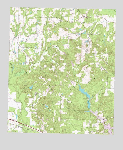
Hainesville, TX USGS Topographic Map
Click on map above to begin viewing in our Map Viewer.

This topographic map contains these locations and features:
Feature Name Type Latitude Longitude GNIS ID View Map
Black CreekStreamN32.6301°W95.3572°1330742View Map
Bobo LakeReservoirN32.6949°W95.3002°1856079View Map
Bobo Lake DamDamN32.6985°W95.3019°1856078View Map
Brooks LakeReservoirN32.7257°W95.2867°1331322View Map
Camp LakeReservoirN32.6703°W95.3484°1856075View Map
Camp Lake DamDamN32.6701°W95.3502°1856074View Map
Clear BranchStreamN32.6454°W95.2719°1332925View Map
Cowan BranchStreamN32.6557°W95.3416°1333556View Map
Dobbs LakeReservoirN32.7176°W95.2841°1334423View Map
Dupree Oil FieldOilfieldN32.7179°W95.2624°1334801View Map
FoukePopulated PlaceN32.6279°W95.2741°1378318View Map
Fouke CemeteryCemeteryN32.6315°W95.2777°1336095View Map
Gentry CemeteryCemeteryN32.6565°W95.3222°1336474View Map
George White BranchStreamN32.6376°W95.2619°1336485View Map
Haines CreekStreamN32.6799°W95.3719°1337225View Map
Haines LakeLakeN32.6911°W95.3703°1337226View Map
HainesvillePopulated PlaceN32.7176°W95.3644°1378403View Map
Hainesville Volunteer Fire DepartmentBuildingN32.7171°W95.3695°2655542View Map
High Meadows Branch LibraryBuildingN32.6737°W95.3277°2014920View Map
Highland Pond BranchStreamN32.6476°W95.2813°1337746View Map
Houston Public LibraryBuildingN32.6887°W95.3694°2014872View Map
Indian Mound DamDamN32.6751°W95.2986°1856076View Map
Indian Mound LakeReservoirN32.6760°W95.2996°1856077View Map
Jayco BranchStreamN32.7368°W95.2686°1338680View Map
Johnson Branch LibraryBuildingN32.6896°W95.3719°2014883View Map
Jones BranchStreamN32.6982°W95.3388°1338829View Map
Kashmere Gardens Branch LibraryBuildingN32.7110°W95.3169°2014890View Map
Lacey BranchStreamN32.6337°W95.3536°1339438View Map
Lake HawkinsReservoirN32.6273°W95.2535°1856051View Map
Lake O the WoodsReservoirN32.6468°W95.2786°1862589View Map
Lake O the Woods DamDamN32.6468°W95.2786°1862588View Map
Lakewood Branch LibraryBuildingN32.7204°W95.2672°2014908View Map
Lower West LakeReservoirN32.6553°W95.2797°1856071View Map
Lower West Lake DamDamN32.6501°W95.2786°1856070View Map
Macedonia ChurchChurchN32.6690°W95.3236°1340802View Map
Mancuso Branch LibraryBuildingN32.7287°W95.3099°2014856View Map
Mansell CemeteryCemeteryN32.7493°W95.2949°1340897View Map
Melcher Branch LibraryBuildingN32.7324°W95.2902°2014869View Map
Mill RaceStreamN32.6785°W95.3733°1341638View Map
Moody Branch LibraryBuildingN32.7357°W95.3625°2014823View Map
Mount Pisgah CemeteryCemeteryN32.7379°W95.3136°1342091View Map
Norman BranchStreamN32.6712°W95.2977°1384179View Map
Octavia Fields Branch LibraryBuildingN32.7451°W95.2655°2014843View Map
Old Fouke CemeteryCemeteryN32.6260°W95.2780°1343151View Map
Page ParkParkN32.6274°W95.2749°1343420View Map
Park Place Regional LibraryBuildingN32.7462°W95.2755°2014848View Map
Patton CreekStreamN32.6932°W95.3736°1375377View Map
Pine MillsPopulated PlaceN32.7415°W95.2894°1378867View Map
Pine Mills ChurchChurchN32.7362°W95.2894°1344066View Map
Poley BranchStreamN32.6699°W95.2858°1344319View Map
Puckett LakeReservoirN32.7052°W95.3681°1344616View Map
Ray CemeteryCemeteryN32.6315°W95.2819°1344847View Map
Red BranchStreamN32.7051°W95.3341°1375663View Map
Red BranchStreamN32.6699°W95.2913°1344898View Map
Redland Acres DamDamN32.6668°W95.3286°1856080View Map
Redland Acres LakeReservoirN32.6677°W95.3289°1856081View Map
Redlands CemeteryCemeteryN32.6649°W95.3427°1344984View Map
Reed CemeteryCemeteryN32.7401°W95.2842°1344993View Map
Rock Falls CreekStreamN32.6557°W95.3605°1345374View Map
Salesmanship Boys ClubBuildingN32.6718°W95.3566°1346174View Map
Shipps LakeReservoirN32.7240°W95.2934°1347081View Map
Shirley Barbara Oil FieldOilfieldN32.7107°W95.2824°1347082View Map
Stagner BranchStreamN32.6854°W95.2974°1347787View Map
Stagner ChurchChurchN32.6871°W95.2588°1347788View Map
Upper West LakeReservoirN32.6669°W95.2858°1856073View Map
Upper West Lake DamDamN32.6601°W95.2802°1856072View Map
West LakesReservoirN32.6501°W95.2791°1349759View Map
Wisenbaker LakeLakeN32.6478°W95.2793°1350440View Map

Note: Coordinates in the location and feature list above are referenced to NAD83 datum.


Copyright (C) 2008-2025 Ryan Niemi / Sunset Dynamics ... All Rights Reserved