TopoQuest Logo
Do you find TopoQuest useful?
Help keep TopoQuest running and adding new maps/features by donating!
Bitcoin:  19c7KJd3qBynnjoSw5npx9KScwjBe4ifkT
Litecoin:  LXs6TkuXGGXo1vDsWCkWVdjQX94eUKd6ui
Home View Maps Find Maps Find Places Resources & Links


Wertzville, Pennsylvania Topographic Map

USGS Map Title: Wertzville, PA
USGS Map MRC: 40077C1
DRG (GeoTIFF) Download: o40077c1.tif


Neighboring USGS Topographic Map Quads:


  Newport, PA  
40077D2
 

  Duncannon, PA  
40077D1
 

  Halifax, PA  
40076D8
 

  Shermans Dale, PA  
40077C2
 

  Wertzville, PA  
40077C1
 

  Harrisburg West, PA  
40076C8
 

  Carlisle, PA  
40077B2
 

  Mechanicsburg, PA  
40077B1
 

  Lemoyne, PA  
40076B8


Map MRC Location:

N41°
W78°
N41°
W77°
H8 H7 H6 H5 H4 H3 H2 H1
G8 G7 G6 G5 G4 G3 G2 G1
F8 F7 F6 F5 F4 F3 F2 F1
E8 E7 E6 E5 E4 E3 E2 E1
D8 D7 D6 D5 D4 D3 D2 D1
C8 C7 C6 C5 C4 C3 C2 C1
B8 B7 B6 B5 B4 B3 B2 B1
A8 A7 A6 A5 A4 A3 A2 A1
N40°
W78°
N40°
W77°

Wertzville, PA USGS 1:24K Topographic Map Preview:
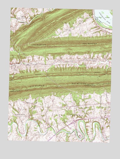
Wertzville, PA USGS Topographic Map
Click on map above to begin viewing in our Map Viewer.

This topographic map contains these locations and features:
Feature Name Type Latitude Longitude GNIS ID View Map
Appalachian National Scenic TrailTrailN40.3221°W77.0775°205110View Map
Cove CreekStreamN40.3704°W77.0214°1172522View Map
Cove Forge (historical)LocaleN40.3709°W77.0230°1197249View Map
Cove MountainSummitN40.3526°W77.0897°1172527View Map
Cox IslandIslandN40.3612°W77.0078°1172562View Map
Deans GapGapN40.2987°W77.1014°1173034View Map
Deitch AirportAirportN40.2594°W77.0832°2442837View Map
DellvillePopulated PlaceN40.3640°W77.1158°1173137View Map
Dellville ChurchChurchN40.3673°W77.1111°1173138View Map
DonnellytownPopulated PlaceN40.2856°W77.0978°1173381View Map
Eckles SchoolSchoolN40.2554°W77.0911°1214061View Map
Elliots SchoolSchoolN40.2793°W77.1072°1214062View Map
Fairview Hall SchoolSchoolN40.2826°W77.0794°1174531View Map
Fio Forge School (historical)SchoolN40.3709°W77.1050°1197254View Map
Green Ridge Elementary SchoolSchoolN40.2684°W77.0514°1211732View Map
Grier PointRidgeN40.3237°W77.1141°1176225View Map
Haunstein AirportAirportN40.3176°W77.1245°2770607View Map
Hogestown RunStreamN40.2543°W77.0266°1177181View Map
Hustons MillPopulated PlaceN40.2554°W77.0375°1177651View Map
Ironstone RidgeRidgeN40.2845°W77.0914°1177855View Map
John P Hall DamDamN40.2618°W77.0464°1194675View Map
KeystonePopulated PlaceN40.3262°W77.0550°1178434View Map
Kinkora HeightsPopulated PlaceN40.3731°W77.0244°1178512View Map
Lambs GapGapN40.3056°W77.0144°1178830View Map
Little MountainRangeN40.3112°W77.0933°1192809View Map
Marysville ReservoirReservoirN40.3138°W77.0068°1180521View Map
Middle Cove ChurchChurchN40.3634°W77.0341°1181017View Map
Millers GapGapN40.3023°W77.0633°1181246View Map
Myers GapGapN40.3084°W77.1200°1182132View Map
Number 1 SchoolSchoolN40.3218°W77.1022°1214085View Map
Number 2 School (historical)SchoolN40.3259°W77.0636°1197253View Map
Oak Grove CemeteryCemeteryN40.3281°W77.0178°1182737View Map
Pleasant Grove SchoolSchoolN40.2731°W77.0616°1184017View Map
Rattling RunStreamN40.3240°W77.0180°1197250View Map
Saint Davids ChurchChurchN40.3670°W77.1122°1185906View Map
Saint Pauls ChurchChurchN40.2862°W77.0158°1186594View Map
Saint Pauls Church (historical)ChurchN40.2859°W77.0155°1197252View Map
Salam ChurchChurchN40.3273°W77.0222°1186803View Map
Silver Spring Golf CourseLocaleN40.2673°W77.0244°1205812View Map
Silver Spring Township Police DepartmentBuildingN40.2512°W77.0318°2754563View Map
Simmons CreekStreamN40.2695°W77.0325°1187698View Map
Simmons SchoolSchoolN40.2826°W77.0303°1214098View Map
State Game Lands Number 170ParkN40.3090°W77.0175°1188468View Map
Township of PennCivilN40.3728°W77.0422°1216947View Map
Township of RyeCivilN40.3247°W77.0395°1216948View Map
Township of Silver SpringCivilN40.2503°W77.0567°1216345View Map
Trindle Spring RunStreamN40.2534°W77.0083°1189766View Map
Trout RunStreamN40.3265°W77.0064°1189848View Map
Upper DamDamN40.3668°W77.0280°1194753View Map
WertzvillePopulated PlaceN40.2837°W77.0439°1190848View Map
Willow Mill ParkParkN40.2590°W77.0411°1191506View Map
Youngs ChurchChurchN40.2823°W77.0589°1191916View Map

Note: Coordinates in the location and feature list above are referenced to NAD83 datum.


Copyright (C) 2008-2024 Ryan Niemi / Sunset Dynamics ... All Rights Reserved