TopoQuest Logo
Do you find TopoQuest useful?
Help keep TopoQuest running and adding new maps/features by donating!
Bitcoin:  19c7KJd3qBynnjoSw5npx9KScwjBe4ifkT
Litecoin:  LXs6TkuXGGXo1vDsWCkWVdjQX94eUKd6ui
Home View Maps Find Maps Find Places Resources & Links


Hamilton SW, Alabama Topographic Map

USGS Map Title: Hamilton SW, AL
USGS Map MRC: 34087A8
DRG (GeoTIFF) Download: o34087a8.tif


Neighboring USGS Topographic Map Quads:


  Weston, AL  
34088B1
 

  Hamilton, AL  
34087B8
 

  Hamilton NE, AL  
34087B7
 

  Henson Springs, AL  
34088A1
 

  Hamilton SW, AL  
34087A8
 

  Brilliant, AL  
34087A7
 

  Beaverton, AL  
33088H1
 

  Guin, AL  
33087H8
 

  Winfield, AL  
33087H7


Map MRC Location:

N35°
W88°
N35°
W87°
H8 H7 H6 H5 H4 H3 H2 H1
G8 G7 G6 G5 G4 G3 G2 G1
F8 F7 F6 F5 F4 F3 F2 F1
E8 E7 E6 E5 E4 E3 E2 E1
D8 D7 D6 D5 D4 D3 D2 D1
C8 C7 C6 C5 C4 C3 C2 C1
B8 B7 B6 B5 B4 B3 B2 B1
A8 A7 A6 A5 A4 A3 A2 A1
N34°
W88°
N34°
W87°

Hamilton SW, AL USGS 1:24K Topographic Map Preview:
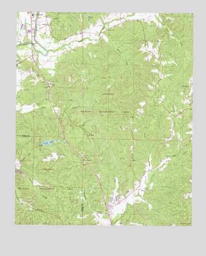
Hamilton SW, AL USGS Topographic Map
Click on map above to begin viewing in our Map Viewer.

This topographic map contains these locations and features:
Feature Name Type Latitude Longitude GNIS ID View Map
Alabama State Troopers Troop ABuildingN34.0812°W87.9758°2752087View Map
Antioch ChurchChurchN34.1173°W87.9403°113167View Map
Banister CemeteryCemeteryN34.0704°W87.9845°113439View Map
County LakeReservoirN34.0483°W87.9774°116711View Map
Donham CemeteryCemeteryN34.1123°W87.9417°117373View Map
Dug Hill Gas FieldOilfieldN34.0084°W87.9875°154857View Map
Flurry BranchStreamN34.0257°W87.9059°118459View Map
Flurry CemeteryCemeteryN34.0201°W87.9072°137972View Map
Green Springs CemeteryCemeteryN34.0812°W87.8770°137984View Map
Green Springs Missionary Baptist ChurchChurchN34.0820°W87.8775°119349View Map
Grizzard BranchStreamN34.0073°W87.9239°119433View Map
Hamilton Aged and Infirmed CenterBuildingN34.1247°W87.9920°2739758View Map
Hamilton Church of ChristChurchN34.1098°W87.9900°148906View Map
Hamilton Gas FieldOilfieldN34.0940°W87.9867°154947View Map
Lamarion Wildlife Management AreaParkN34.0015°W87.9986°155545View Map
Liberty CemeteryCemeteryN34.0393°W87.9220°152032View Map
Liberty CemeteryCemeteryN34.0390°W87.9175°137998View Map
Liberty Freewill Baptist ChurchChurchN34.0384°W87.9181°152045View Map
Marion County Public Lake DamDamN34.0468°W87.9817°131920View Map
Marion County-Rankin Fite AirportAirportN34.1173°W87.9960°129489View Map
Maywood CampLocaleN34.1218°W87.9498°122433View Map
McKinley CemeteryCemeteryN34.1070°W87.9192°122574View Map
Moses CemeteryCemeteryN34.1173°W87.9039°123106View Map
New Hope CemeteryCemeteryN34.0020°W87.8784°123790View Map
New Hope ChurchChurchN34.0015°W87.8778°138030View Map
Northwest Alabama State Trade SchoolSchoolN34.1234°W87.9892°152712View Map
Philadelphia CemeteryCemeteryN34.0087°W87.9378°138046View Map
Philadelphia United Methodist ChurchChurchN34.0082°W87.9373°152882View Map
PikevillePopulated PlaceN34.0382°W87.9511°156885View Map
Pikeville CemeteryCemeteryN34.0365°W87.9520°124724View Map
Pikeville Country ClubLocaleN34.0404°W87.9703°164398View Map
Pleasant Grove Baptist ChurchChurchN34.1148°W87.9375°152983View Map
Pleasant Grove CemeteryCemeteryN34.1140°W87.9361°138048View Map
StinsonPopulated PlaceN34.0209°W87.9078°157114View Map
Summers BranchStreamN34.0326°W87.9964°127539View Map
Terrell CemeteryCemeteryN34.0412°W87.9525°127767View Map
Terrell CemeteryCemeteryN34.0929°W87.9517°154424View Map
Terrell CemeteryCemeteryN34.0998°W87.9892°138073View Map
WERH-AM (Hamilton)TowerN34.1170°W87.9914°161053View Map
WERH-FM (Hamilton)TowerN34.1170°W87.9914°161210View Map
Whitley CreekStreamN34.1134°W87.9420°128924View Map
Williams CemeteryCemeteryN34.0932°W87.9561°138088View Map
Woods CreekStreamN34.1020°W87.9786°154502View Map
Woods Creek Gas FieldOilfieldN34.1087°W87.9070°154955View Map

Note: Coordinates in the location and feature list above are referenced to NAD83 datum.


Copyright (C) 2008-2025 Ryan Niemi / Sunset Dynamics ... All Rights Reserved