TopoQuest Logo
Do you find TopoQuest useful?
Help keep TopoQuest running and adding new maps/features by donating!
Bitcoin:  19c7KJd3qBynnjoSw5npx9KScwjBe4ifkT
Litecoin:  LXs6TkuXGGXo1vDsWCkWVdjQX94eUKd6ui
Home View Maps Find Maps Find Places Resources & Links


Beaverton, Alabama Topographic Map

USGS Map Title: Beaverton, AL
USGS Map MRC: 33088H1
DRG (GeoTIFF) Download: o33088h1.tif


Neighboring USGS Topographic Map Quads:


  Detroit, AL  
34088A2
 

  Henson Springs, AL  
34088A1
 

  Hamilton SW, AL  
34087A8
 

  Sulligent, AL  
33088H2
 

  Beaverton, AL  
33088H1
 

  Guin, AL  
33087H8
 

  Sulligent SW, AL  
33088G2
 

  Vernon, AL  
33088G1
 

  Bluff, AL  
33087G8


Map MRC Location:

N34°
W89°
N34°
W88°
H8 H7 H6 H5 H4 H3 H2 H1
G8 G7 G6 G5 G4 G3 G2 G1
F8 F7 F6 F5 F4 F3 F2 F1
E8 E7 E6 E5 E4 E3 E2 E1
D8 D7 D6 D5 D4 D3 D2 D1
C8 C7 C6 C5 C4 C3 C2 C1
B8 B7 B6 B5 B4 B3 B2 B1
A8 A7 A6 A5 A4 A3 A2 A1
N33°
W89°
N33°
W88°

Beaverton, AL USGS 1:24K Topographic Map Preview:
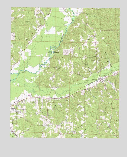
Beaverton, AL USGS Topographic Map
Click on map above to begin viewing in our Map Viewer.

This topographic map contains these locations and features:
Feature Name Type Latitude Longitude GNIS ID View Map
Armstrong BranchStreamN33.9284°W88.0409°113218View Map
Armstrong Branch Gas FieldOilfieldN33.9201°W88.0195°154859View Map
Beaver CreekStreamN33.9296°W88.1236°113732View Map
Beaver Creek Gas FieldOilfieldN33.9445°W88.0042°154860View Map
BeavertonPopulated PlaceN33.9312°W88.0203°113775View Map
Beaverton Freewill Baptist ChurchChurchN33.9677°W88.0293°2084035View Map
Beaverton Gas FieldOilfieldN33.9640°W88.1056°154858View Map
Beaverton Memorial CemeteryCemeteryN33.9265°W88.0167°158437View Map
Beaverton Post OfficePost OfficeN33.9318°W88.0210°166644View Map
Beaverton Volunteer Fire DepartmentBuildingN33.9288°W88.0250°2683308View Map
CrewsPopulated PlaceN33.9132°W88.0806°116863View Map
Crews CemeteryCemeteryN33.9090°W88.0839°158442View Map
Crews Methodist ChurchChurchN33.9087°W88.0836°116864View Map
Crews Mill BranchStreamN33.9176°W88.0734°116865View Map
Hawkins FordCrossingN33.9576°W88.0775°156457View Map
Hays FordCrossingN33.9934°W88.0525°156462View Map
Hollis CemeteryCemeteryN33.9070°W88.0450°120259View Map
Loggains BranchStreamN33.9368°W88.1239°121968View Map
Lost John (historical)LocaleN33.9737°W88.0292°132783View Map
Lost John ChurchChurchN33.9729°W88.0298°122036View Map
Mill CreekStreamN33.9398°W88.1103°122796View Map
Monroe BranchStreamN33.9351°W88.0303°122954View Map
Mount Hebron CemeteryCemeteryN33.9426°W88.0731°132792View Map
Mount Hebron ChurchChurchN33.9423°W88.0723°123209View Map
Nolen CemeteryCemeteryN33.9029°W88.0889°123963View Map
Olive Hill CemeteryCemeteryN33.9559°W88.0056°124279View Map
Pope CemeteryCemeteryN33.9687°W88.1070°158468View Map
Pope ChurchChurchN33.9693°W88.1078°125139View Map
Prospect ChurchChurchN33.8876°W88.0667°125308View Map
Reedy BranchStreamN33.9570°W88.0006°125526View Map
Roy Mill BranchStreamN33.9940°W88.0528°126004View Map
Sharon ChurchChurchN33.9484°W88.0125°126632View Map
Sizemore Memorial CemeteryCemeteryN33.9254°W88.0153°158473View Map
Spruiell BranchStreamN33.9687°W88.0895°127291View Map
Spruiell CemeteryCemeteryN33.9815°W88.0934°127292View Map
Stanford BranchStreamN33.9432°W88.0056°127302View Map
Stanford CemeteryCemeteryN33.9479°W88.0172°127304View Map
Stanford CemeteryCemeteryN33.9859°W88.1056°127305View Map
Stuckey LakeReservoirN33.9574°W88.0757°127481View Map
Sulligent DivisionCivilN33.9461°W88.0969°165830View Map
Town of BeavertonCivilN33.9354°W88.0218°2405225View Map
Turkey BranchStreamN33.9345°W88.0189°128134View Map
Union Ridge ChurchChurchN33.9720°W88.1225°128347View Map
Wayside Gas FieldOilfieldN33.8862°W88.0028°154861View Map
Wayside Oil FieldOilfieldN33.8759°W88.0042°154863View Map

Note: Coordinates in the location and feature list above are referenced to NAD83 datum.


Copyright (C) 2008-2025 Ryan Niemi / Sunset Dynamics ... All Rights Reserved