TopoQuest Logo
Do you find TopoQuest useful?
Help keep TopoQuest running and adding new maps/features by donating!
Bitcoin:  19c7KJd3qBynnjoSw5npx9KScwjBe4ifkT
Litecoin:  LXs6TkuXGGXo1vDsWCkWVdjQX94eUKd6ui
Home View Maps Find Maps Find Places Resources & Links


Hamilton NE, Alabama Topographic Map

USGS Map Title: Hamilton NE, AL
USGS Map MRC: 34087B7
DRG (GeoTIFF) Download: o34087b7.tif


Neighboring USGS Topographic Map Quads:


  Hodges, AL  
34087C8
 

  Hackleburg, AL  
34087C7
 

  Phil Campbell, AL  
34087C6
 

  Hamilton, AL  
34087B8
 

  Hamilton NE, AL  
34087B7
 

  Haleyville West, AL  
34087B6
 

  Hamilton SW, AL  
34087A8
 

  Brilliant, AL  
34087A7
 

  Gold Mine, AL  
34087A6


Map MRC Location:

N35°
W88°
N35°
W87°
H8 H7 H6 H5 H4 H3 H2 H1
G8 G7 G6 G5 G4 G3 G2 G1
F8 F7 F6 F5 F4 F3 F2 F1
E8 E7 E6 E5 E4 E3 E2 E1
D8 D7 D6 D5 D4 D3 D2 D1
C8 C7 C6 C5 C4 C3 C2 C1
B8 B7 B6 B5 B4 B3 B2 B1
A8 A7 A6 A5 A4 A3 A2 A1
N34°
W88°
N34°
W87°

Hamilton NE, AL USGS 1:24K Topographic Map Preview:
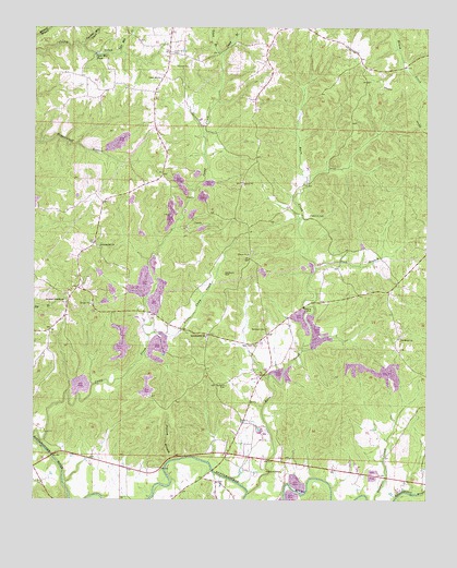
Hamilton NE, AL USGS Topographic Map
Click on map above to begin viewing in our Map Viewer.

This topographic map contains these locations and features:
Feature Name Type Latitude Longitude GNIS ID View Map
Armstrong CemeteryCemeteryN34.1693°W87.8331°137924View Map
Barn CreekStreamN34.1268°W87.8067°113484View Map
Barn Creek ChurchChurchN34.1662°W87.8039°113485View Map
BrinnPopulated PlaceN34.1687°W87.8009°137941View Map
Burelson ChurchChurchN34.1368°W87.8064°137945View Map
Burleson CemeteryCemeteryN34.1712°W87.7645°137943View Map
Burleson CemeteryCemeteryN34.1693°W87.8197°137944View Map
Burleson CemeteryCemeteryN34.1318°W87.7945°154428View Map
Burleson CemeteryCemeteryN34.1554°W87.8134°115234View Map
Burleson CemeteryCemeteryN34.1704°W87.8006°115235View Map
Buttahatchee Junior High SchoolSchoolN34.1687°W87.8195°165368View Map
Camp BranchStreamN34.2432°W87.8145°115442View Map
Camp CreekStreamN34.1420°W87.8748°115455View Map
Church of ChristChurchN34.1326°W87.7959°116118View Map
Cook BranchStreamN34.1865°W87.7853°116524View Map
Federick CemeteryCemeteryN34.2004°W87.7870°118234View Map
Green BranchStreamN34.2432°W87.8145°119328View Map
Green CemeteryCemeteryN34.2320°W87.8209°137982View Map
Little Camp CreekStreamN34.1687°W87.8386°121727View Map
Old Bethel CemeteryCemeteryN34.1687°W87.7578°138037View Map
Old Bethel Missionary Baptist ChurchChurchN34.1676°W87.7586°154481View Map
Pleasant Hill ChurchChurchN34.1920°W87.8542°124978View Map
Possum BranchStreamN34.1354°W87.8311°125190View Map
Southern Schoolhouse ChurchChurchN34.1770°W87.8648°154496View Map
Sullens CemeteryCemeteryN34.1301°W87.8161°138071View Map
Sullins CemeteryCemeteryN34.1765°W87.8650°138072View Map
Tyre Mill CreekStreamN34.2432°W87.8473°128239View Map
Tyre Mill PondLakeN34.2430°W87.8553°128240View Map
Union Hill CemeteryCemeteryN34.2431°W87.8306°153788View Map
Union Hill Freewill Baptist ChurchChurchN34.2365°W87.8339°153789View Map
Weatherly CemeteryCemeteryN34.1856°W87.8136°128660View Map
Yielding Mill CreekStreamN34.2454°W87.8598°129301View Map

Note: Coordinates in the location and feature list above are referenced to NAD83 datum.


Copyright (C) 2008-2024 Ryan Niemi / Sunset Dynamics ... All Rights Reserved