TopoQuest Logo
Do you find TopoQuest useful?
Help keep TopoQuest running and adding new maps/features by donating!
Bitcoin:  19c7KJd3qBynnjoSw5npx9KScwjBe4ifkT
Litecoin:  LXs6TkuXGGXo1vDsWCkWVdjQX94eUKd6ui
Home View Maps Find Maps Find Places Resources & Links


Hamlin, Kentucky Topographic Map

USGS Map Title: Hamlin, KY
USGS Map MRC: 36088E1
DRG (GeoTIFF) Download: o36088e1.tif


Neighboring USGS Topographic Map Quads:


  Hico, KY  
36088F2
 

  Rushing Bay, TN  
36088F1
 

  Linton, KY  
36087F8
 

  New Concord, KY  
36088E2
 

  Hamlin, KY  
36088E1
 

  Tharpe, TN  
36087E8
 

  Buchanan, TN  
36088D2
 

  Paris Landing, TN  
36088D1
 

  Standing Rock, TN  
36087D8


Map MRC Location:

N37°
W89°
N37°
W88°
H8 H7 H6 H5 H4 H3 H2 H1
G8 G7 G6 G5 G4 G3 G2 G1
F8 F7 F6 F5 F4 F3 F2 F1
E8 E7 E6 E5 E4 E3 E2 E1
D8 D7 D6 D5 D4 D3 D2 D1
C8 C7 C6 C5 C4 C3 C2 C1
B8 B7 B6 B5 B4 B3 B2 B1
A8 A7 A6 A5 A4 A3 A2 A1
N36°
W89°
N36°
W88°

Hamlin, KY USGS 1:24K Topographic Map Preview:
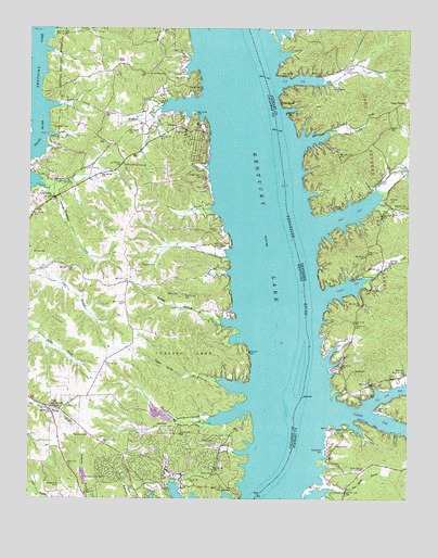
Hamlin, KY USGS Topographic Map
Click on map above to begin viewing in our Map Viewer.

This topographic map contains these locations and features:
Feature Name Type Latitude Longitude GNIS ID View Map
Azotus ChurchChurchN36.5776°W88.0045°1276033View Map
Bailey CemeteryCemeteryN36.5544°W88.0756°486213View Map
Bailey CemeteryCemeteryN36.5550°W88.0142°1308775View Map
Bailey CemeteryCemeteryN36.5773°W88.0222°1276108View Map
Bailey HollowValleyN36.5475°W88.0615°486227View Map
Blood River CemeteryCemeteryN36.6133°W88.0858°487490View Map
Blood River ChurchChurchN36.5889°W88.0934°487491View Map
Blood River Fire StationBuildingN36.5877°W88.0937°2637193View Map
Blue Spring ChurchChurchN36.5342°W88.0006°1277803View Map
Blue Spring School (historical)SchoolN36.5273°W88.0125°1308785View Map
Blue Springs Lake Access AreaParkN36.5301°W88.0123°1308786View Map
Boswell CemeteryCemeteryN36.5145°W88.0239°1278024View Map
Boswell Landing (historical)LocaleN36.5162°W88.0356°1308791View Map
Boswell Landing Lake Access AreaParkN36.5173°W88.0264°1308792View Map
Boyds BranchStreamN36.6037°W88.0806°487775View Map
Brigham CemeteryCemeteryN36.5795°W88.0064°1278381View Map
Buchannan CemeteryCemeteryN36.5128°W88.0267°1278784View Map
Byrd BayBayN36.5764°W88.0195°1308815View Map
Byrd CemeteryCemeteryN36.5878°W88.0070°1308805View Map
Byrd CreekStreamN36.5726°W88.0303°1279254View Map
Calloway County Fire and Rescue Station 11 New ConcordBuildingN36.5234°W88.1136°2637332View Map
Camp TischelLocaleN36.6051°W88.0014°1279414View Map
Campbell CemeteryCemeteryN36.5187°W88.0247°1279442View Map
Clay BayBayN36.6114°W88.0381°1308817View Map
Clay CreekStreamN36.6106°W88.0434°1305943View Map
Dill CemeteryCemeteryN36.5778°W88.0028°1282471View Map
Dill Landing (historical)LocaleN36.6134°W88.0461°1308827View Map
Dry Fork BayBayN36.5278°W88.0070°1308835View Map
Dry Fork CreekStreamN36.5242°W88.0142°1282981View Map
Fakes CemeteryCemeteryN36.5155°W88.0641°491940View Map
Ferguson CemeteryCemeteryN36.5621°W88.0887°492029View Map
Fort BranchStreamN36.5103°W88.0375°1308843View Map
Fort HeimanPopulated PlaceN36.5020°W88.0559°508026View Map
Fort HenryPopulated PlaceN36.5073°W88.0159°1284665View Map
Fort Henry BranchStreamN36.5031°W88.0264°1284666View Map
Fort Henry Landing (historical)LocaleN36.5062°W88.0403°1308846View Map
Ginger Bay Lake Access AreaParkN36.6237°W88.0384°1308850View Map
Grindstone CreekStreamN36.5820°W88.1173°493401View Map
HamlinPopulated PlaceN36.5984°W88.0764°508168View Map
Hendon CemeteryCemeteryN36.5442°W88.0278°1308866View Map
Herndon CemeteryCemeteryN36.5442°W88.0286°1287496View Map
Hickory Shed Landing (historical)LocaleN36.5395°W88.0311°1308868View Map
Hughes BayBayN36.5564°W88.0195°1308874View Map
Hughes CreekStreamN36.5542°W88.0278°1288674View Map
Iron Valley Landing (historical)LocaleN36.5734°W88.0373°1308877View Map
Kimbro CemeteryCemeteryN36.5867°W88.0685°495730View Map
Lassiter CemeteryCemeteryN36.6095°W88.0687°495997View Map
Lassiter CemeteryCemeteryN36.6054°W88.0829°495998View Map
Lassiter CemeteryCemeteryN36.5988°W88.0835°2775700View Map
Lick CreekStreamN36.5787°W88.0103°1291221View Map
Mallory CemeteryCemeteryN36.5714°W88.0631°497473View Map
Marbury CemeteryCemeteryN36.5628°W88.0247°1308896View Map
Mathes CemeteryCemeteryN36.5342°W88.0178°1292922View Map
McClure Landing (historical)LocaleN36.6209°W88.0486°1308897View Map
McCuiston CemeteryCemeteryN36.5168°W88.1051°497827View Map
McCullochs BarBarN36.5656°W88.0364°1642950View Map
Model Landing (historical)LocaleN36.6164°W88.0473°1308908View Map
Moody CemeteryCemeteryN36.5069°W88.0637°498521View Map
Mount Carmel (historical)Populated PlaceN36.5242°W88.1185°2743635View Map
Mount Zion CemeteryCemeteryN36.5654°W88.1240°498913View Map
New Mount Carmel ChurchChurchN36.5237°W88.1161°499375View Map
Oak Level CemeteryCemeteryN36.5997°W88.0704°499716View Map
Panther BarBarN36.5217°W88.0361°1642955View Map
Panther BayBayN36.5212°W88.0084°1308932View Map
Panther CreekStreamN36.5234°W88.0256°1296745View Map
Pine BluffCliffN36.6053°W88.0423°1297510View Map
Pine Bluff Ferry (historical)LocaleN36.6067°W88.0459°1308938View Map
Pine Bluff Landing (historical)LocaleN36.6042°W88.0431°1308939View Map
Saint Johns Landing (historical)LocaleN36.5539°W88.0320°1308959View Map
Saint Johns School (historical)SchoolN36.5712°W88.0159°1308960View Map
Shackleford CemeteryCemeteryN36.5039°W88.1150°503203View Map
Shannon CreekStreamN36.5201°W88.0634°503243View Map
Stilley - McCuiston CemeteryCemeteryN36.5805°W88.1187°504399View Map
Thomas Landing (historical)LocaleN36.6070°W88.0439°1308994View Map
Tischel BayBayN36.5959°W88.0320°1649790View Map
Tischel CreekStreamN36.5945°W88.0356°1304118View Map
Tishel Landing (historical)LocaleN36.5964°W88.0411°1308998View Map
VinsonPopulated PlaceN36.6153°W88.0209°1309004View Map
Vinson CemeteryCemeteryN36.6098°W88.0253°1273479View Map
Vinson School (historical)SchoolN36.6151°W88.0223°1309007View Map
Wallace CemeteryCemeteryN36.5600°W88.0156°1273679View Map
Winchester CemeteryCemeteryN36.5985°W88.1177°506925View Map
Yellow Spring BranchStreamN36.5312°W88.0609°507222View Map

Note: Coordinates in the location and feature list above are referenced to NAD83 datum.


Copyright (C) 2008-2024 Ryan Niemi / Sunset Dynamics ... All Rights Reserved