TopoQuest Logo
Do you find TopoQuest useful?
Help keep TopoQuest running and adding new maps/features by donating!
Bitcoin:  19c7KJd3qBynnjoSw5npx9KScwjBe4ifkT
Litecoin:  LXs6TkuXGGXo1vDsWCkWVdjQX94eUKd6ui
Home View Maps Find Maps Find Places Resources & Links


Tharpe, Tennessee Topographic Map

USGS Map Title: Tharpe, TN
USGS Map MRC: 36087E8
DRG (GeoTIFF) Download: o36087e8.tif


Neighboring USGS Topographic Map Quads:


  Rushing Bay, TN  
36088F1
 

  Linton, KY  
36087F8
 

  Johnson Hollow, KY  
36087F7
 

  Hamlin, KY  
36088E1
 

  Tharpe, TN  
36087E8
 

  Bumpus Mills, TN  
36087E7
 

  Paris Landing, TN  
36088D1
 

  Standing Rock, TN  
36087D8
 

  Dover, TN  
36087D7


Map MRC Location:

N37°
W88°
N37°
W87°
H8 H7 H6 H5 H4 H3 H2 H1
G8 G7 G6 G5 G4 G3 G2 G1
F8 F7 F6 F5 F4 F3 F2 F1
E8 E7 E6 E5 E4 E3 E2 E1
D8 D7 D6 D5 D4 D3 D2 D1
C8 C7 C6 C5 C4 C3 C2 C1
B8 B7 B6 B5 B4 B3 B2 B1
A8 A7 A6 A5 A4 A3 A2 A1
N36°
W88°
N36°
W87°

Tharpe, TN USGS 1:24K Topographic Map Preview:
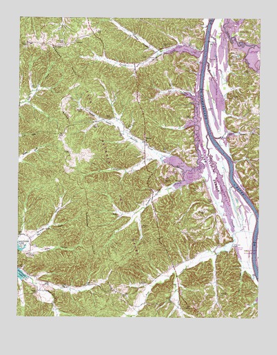
Tharpe, TN USGS Topographic Map
Click on map above to begin viewing in our Map Viewer.

This topographic map contains these locations and features:
Feature Name Type Latitude Longitude GNIS ID View Map
Andersons Landing (historical)LocaleN36.6039°W87.9053°1642920View Map
Bards CreekStreamN36.5951°W87.9061°1304954View Map
Bards DamDamN36.5601°W87.9067°1302679View Map
Bards LakeReservoirN36.5613°W87.9143°1302678View Map
Barrett CreekStreamN36.5651°W87.9239°1304973View Map
Barrow CemeteryCemeteryN36.6138°W87.9963°1276391View Map
Bear CreekStreamN36.5773°W87.9014°1276603View Map
Bear Creek Waterfowl Management UnitParkN36.5631°W87.8972°1308778View Map
Bee BranchStreamN36.5176°W87.9172°1276767View Map
Beech Fork CreekStreamN36.6139°W87.8778°1276817View Map
Blue CreekStreamN36.5364°W87.8753°1277754View Map
Boswell CemeteryCemeteryN36.5103°W87.9900°1278023View Map
Boyd CemeteryCemeteryN36.5342°W87.9997°1278110View Map
Brandon CemeteryCemeteryN36.5681°W87.8872°1278231View Map
Brandon SpringSpringN36.5570°W87.9159°1308795View Map
Brandon Spring BranchStreamN36.5576°W87.9139°1305394View Map
Brandon Spring Group CampLocaleN36.5606°W87.9197°1308796View Map
Brandons Landing (historical)LocaleN36.5684°W87.8920°1642928View Map
Brown CemeteryCemeteryN36.5862°W87.9678°1278565View Map
Bruton CemeteryCemeteryN36.5428°W87.9484°1278728View Map
Bruton Spring BranchStreamN36.5756°W87.8992°1278729View Map
Buckingham HollowValleyN36.5012°W87.9976°1278872View Map
Bufford CemeteryCemeteryN36.5073°W87.9203°1278923View Map
Bumpus Mills Recreation AreaParkN36.6198°W87.8834°1308801View Map
Burgess HollowValleyN36.5827°W87.9497°1308803View Map
Byrd CemeteryCemeteryN36.5962°W87.9917°1279251View Map
Cathey CemeteryCemeteryN36.6089°W87.9345°1279895View Map
Commissioner District 4CivilN36.5627°W87.9566°2464088View Map
Cow CreekStreamN36.5359°W87.8867°1281443View Map
Crutcher HollowValleyN36.6112°W87.9289°1281772View Map
Dennis CemeteryCemeteryN36.5445°W87.8981°1282339View Map
Dry BranchStreamN36.5009°W87.9384°1282891View Map
Dunlap CemeteryCemeteryN36.5762°W87.9478°1283191View Map
Elliots Landing (historical)LocaleN36.5942°W87.9047°1308838View Map
Fox HollowValleyN36.5925°W87.9097°1284782View Map
Gatlin CemeteryCemeteryN36.5492°W87.8995°1285247View Map
Gatlin Point Lake AccessParkN36.5631°W87.9064°1308848View Map
Happy HollowValleyN36.5252°W87.8983°1308862View Map
Happy Hollow BranchStreamN36.5270°W87.8964°1308863View Map
Harris BranchStreamN36.6212°W87.8931°1308865View Map
Herndon CemeteryCemeteryN36.5573°W87.9242°1287497View Map
Hickory Grove ChurchChurchN36.5317°W87.9070°1287596View Map
Hickory HollowValleyN36.5345°W87.9975°1308867View Map
Hicks CemeteryCemeteryN36.5839°W87.9525°1287658View Map
Hicks Landing (historical)LocaleN36.6095°W87.9042°1642942View Map
Hill Top CemeteryCemeteryN36.5800°W87.9436°1287806View Map
Hopewell ChurchChurchN36.5123°W87.9372°1288320View Map
Horton Chapel (historical)ChurchN36.5098°W87.9928°1308872View Map
Houston CemeteryCemeteryN36.6085°W87.9326°1288510View Map
Jackson HollowValleyN36.5813°W87.9508°1289231View Map
Jackson LandingLocaleN36.5362°W87.8753°1642943View Map
Keel CemeteryCemeteryN36.5137°W87.9620°1289945View Map
Knott CemeteryCemeteryN36.5918°W87.8878°1290390View Map
Legate CemeteryCemeteryN36.5872°W87.9022°1290999View Map
Lone Pine CemeteryCemeteryN36.5971°W87.9226°1291851View Map
Luton CemeteryCemeteryN36.5748°W87.8806°1292315View Map
Mannings LandingLocaleN36.6226°W87.9025°1642948View Map
Miles CemeteryCemeteryN36.5384°W87.9353°1293774View Map
Model Division (historical)CensusN36.5601°W87.9584°1648965View Map
Morgan CemeteryCemeteryN36.5692°W87.9734°1294362View Map
Mount Zion CemeteryCemeteryN36.5628°W87.9181°1294865View Map
Neville BayBayN36.6120°W87.9111°1308919View Map
Neville BaySwampN36.6126°W87.9167°1307397View Map
Neville Bay Lake AccessParkN36.6139°W87.9147°1308920View Map
Neville CreekStreamN36.6087°W87.9292°1306816View Map
Neville Creek CemeteryCemeteryN36.6139°W87.9253°1295414View Map
Neville Creek ChurchChurchN36.6134°W87.9253°1308921View Map
New Ground HollowValleyN36.5383°W87.9824°1308922View Map
Nolan CemeteryCemeteryN36.5840°W87.9110°1295802View Map
Nolin RidgeRidgeN36.6045°W87.9250°1647100View Map
Nolins Landing (historical)LocaleN36.5862°W87.9042°1642954View Map
Oak Grove ChurchChurchN36.6151°W87.9709°1296118View Map
Pea Ridge School (historical)SchoolN36.5328°W87.9314°1308935View Map
Pettit CemeteryCemeteryN36.6194°W87.9596°1297264View Map
Popular Springs School (historical)SchoolN36.6131°W87.9242°1308942View Map
Rawles Landing (historical)LocaleN36.5212°W87.8772°1642956View Map
Rawls PondLakeN36.5276°W87.8857°1308946View Map
Rayburn CreekStreamN36.5628°W87.9245°1308947View Map
Ross CemeteryCemeteryN36.6027°W87.8805°1300123View Map
Round TopSummitN36.6006°W87.9695°1308955View Map
Saline Creek Access PointParkN36.6167°W87.8878°1642959View Map
Saline Creek Public Use AreaParkN36.6112°W87.8820°1308962View Map
Scarborough CemeteryCemeteryN36.5131°W87.9789°1308964View Map
Shammels Mound Landing (historical)LocaleN36.5406°W87.8759°1642961View Map
Shemwell CemeteryCemeteryN36.5300°W87.8881°1270029View Map
Shemwell CemeteryCemeteryN36.6079°W87.9020°1270030View Map
Shemwell CemeteryCemeteryN36.6103°W87.8866°1270031View Map
Sills CemeteryCemeteryN36.6081°W87.9313°1270269View Map
Sills CemeteryCemeteryN36.6177°W87.9420°1270270View Map
SniderPopulated PlaceN36.6214°W87.9128°1308977View Map
South Fork Panther CreekStreamN36.5048°W87.9811°1270882View Map
Stall CemeteryCemeteryN36.5131°W87.9745°1271203View Map
Stewarts Landing (historical)LocaleN36.6001°W87.9059°1642965View Map
Stilly HollowValleyN36.5290°W87.9955°1271435View Map
Stone CemeteryCemeteryN36.5539°W87.9072°1271482View Map
TharpePopulated PlaceN36.5737°W87.9345°1272360View Map
Tharpe ChurchChurchN36.5678°W87.9184°1272361View Map
Tharpe School (historical)SchoolN36.5756°W87.9345°1308992View Map
Tip TopPopulated PlaceN36.5389°W87.8967°1308997View Map
Tiptop ChurchChurchN36.5381°W87.8970°1304117View Map
Walker BranchStreamN36.6070°W87.9031°1309008View Map
Walkers Landing (historical)LocaleN36.6062°W87.9034°1642970View Map
Whitford CemeteryCemeteryN36.5103°W87.8947°1304562View Map
Whitford CemeteryCemeteryN36.5703°W87.9250°1274478View Map
Wildcat HollowValleyN36.5328°W87.9951°1274549View Map
Wilkinson CemeteryCemeteryN36.5798°W87.9617°1274600View Map
Williams CemeteryCemeteryN36.5448°W87.9034°1274684View Map
Williams Landing (historical)LocaleN36.5628°W87.8903°1642972View Map

Note: Coordinates in the location and feature list above are referenced to NAD83 datum.


Copyright (C) 2008-2025 Ryan Niemi / Sunset Dynamics ... All Rights Reserved