TopoQuest Logo
Do you find TopoQuest useful?
Help keep TopoQuest running and adding new maps/features by donating!
Bitcoin:  19c7KJd3qBynnjoSw5npx9KScwjBe4ifkT
Litecoin:  LXs6TkuXGGXo1vDsWCkWVdjQX94eUKd6ui
Home View Maps Find Maps Find Places Resources & Links


Linton, Kentucky Topographic Map

USGS Map Title: Linton, KY
USGS Map MRC: 36087F8
DRG (GeoTIFF) Download: o36087f8.tif


Neighboring USGS Topographic Map Quads:


  Fenton, KY  
36088G1
 

  Canton, KY  
36087G8
 

  Cadiz, KY  
36087G7
 

  Rushing Bay, TN  
36088F1
 

  Linton, KY  
36087F8
 

  Johnson Hollow, KY  
36087F7
 

  Hamlin, KY  
36088E1
 

  Tharpe, TN  
36087E8
 

  Bumpus Mills, TN  
36087E7


Map MRC Location:

N37°
W88°
N37°
W87°
H8 H7 H6 H5 H4 H3 H2 H1
G8 G7 G6 G5 G4 G3 G2 G1
F8 F7 F6 F5 F4 F3 F2 F1
E8 E7 E6 E5 E4 E3 E2 E1
D8 D7 D6 D5 D4 D3 D2 D1
C8 C7 C6 C5 C4 C3 C2 C1
B8 B7 B6 B5 B4 B3 B2 B1
A8 A7 A6 A5 A4 A3 A2 A1
N36°
W88°
N36°
W87°

Linton, KY USGS 1:24K Topographic Map Preview:
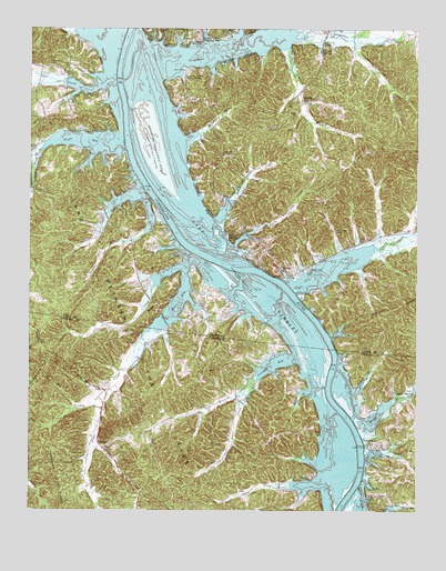
Linton, KY USGS Topographic Map
Click on map above to begin viewing in our Map Viewer.

This topographic map contains these locations and features:
Feature Name Type Latitude Longitude GNIS ID View Map
Acree CreekStreamN36.6320°W87.9064°1275442View Map
Big Hurricane CreekStreamN36.6992°W87.9392°487196View Map
Big Joe SpringSpringN36.6953°W87.9339°487200View Map
Blaines Landing (historical)LocaleN36.6514°W87.9009°1642924View Map
Boyd Hill ChurchChurchN36.7172°W87.9362°487769View Map
Brandon CemeteryCemeteryN36.6533°W87.8785°1308794View Map
Buffalo TrailTrailN36.6453°W87.9814°1308798View Map
Calhoun Hill Public Use AreaParkN36.7464°W87.9442°488611View Map
Champion CemeteryCemeteryN36.6659°W87.9255°1308811View Map
Cherry CemeteryCemeteryN36.6536°W87.9334°1308812View Map
Craig BranchStreamN36.7442°W87.9167°490263View Map
Crockett BayBayN36.6639°W87.9209°1281635View Map
Crockett BranchStreamN36.6578°W87.9275°1306181View Map
Crockett CreekStreamN36.6648°W87.9150°1281647View Map
Crockett Creek Church (historical)ChurchN36.6498°W87.9320°1308819View Map
Crockett Creek School (historical)SchoolN36.6526°W87.9300°1308820View Map
Donaldson CreekStreamN36.7412°W87.9600°491000View Map
Donaldson Creek Public Use AreaParkN36.7367°W87.9497°491002View Map
Downs BranchStreamN36.6964°W87.9622°491077View Map
Dry CreekStreamN36.6917°W87.8875°491170View Map
Fords BayBayN36.7206°W87.9828°492312View Map
Fords CreekStreamN36.7178°W87.9967°492315View Map
Fox RidgeRidgeN36.6737°W87.9642°492414View Map
Great Western Iron Furnace (historical)LocaleN36.6406°W87.9750°1308855View Map
Hicks CemeteryCemeteryN36.6687°W87.9603°1287659View Map
Jimerson CemeteryCemeteryN36.6340°W87.9092°1289438View Map
Kingins CemeteryCemeteryN36.6426°W87.8839°1308881View Map
Laura Furnace CreekStreamN36.7143°W87.9981°496002View Map
Lick CreekStreamN36.7345°W87.9784°496476View Map
LintonPopulated PlaceN36.6867°W87.9186°496592View Map
Linton Public Use AreaParkN36.6859°W87.9109°496593View Map
Linton Volunteer Fire DepartmentBuildingN36.6874°W87.9134°2636959View Map
Little Hurricane CreekStreamN36.6928°W87.9334°496761View Map
ModelLocaleN36.6417°W87.9772°1294144View Map
Model School (historical)SchoolN36.6376°W87.9725°1325376View Map
Mount Vernon CemeteryCemeteryN36.6970°W87.9011°498882View Map
Newt Wallace CemeteryCemeteryN36.6566°W87.8762°1309009View Map
Outland CemeteryCemeteryN36.6605°W87.9285°1296530View Map
Parsons CreekStreamN36.7334°W87.9842°500223View Map
Pinner Spring BranchStreamN36.6381°W87.8917°1308985View Map
Pleasant Hill CemeteryCemeteryN36.7398°W87.9936°500841View Map
Powell BranchStreamN36.6559°W87.8950°1298395View Map
Pryor BayBayN36.6812°W87.9500°501397View Map
Pryor BayBayN36.6792°W87.9517°1298630View Map
Pryor CreekStreamN36.6917°W87.9476°1306928View Map
Rat BranchStreamN36.6512°W87.9764°1298930View Map
Riverside Landing (historical)LocaleN36.6328°W87.8925°1642957View Map
Roberts CemeteryCemeteryN36.6646°W87.8982°1308952View Map
Ross BranchStreamN36.6562°W87.9089°1300111View Map
Ross CemeteryCemeteryN36.6553°W87.9170°1308953View Map
Rowlett BranchStreamN36.6506°W87.9000°1308956View Map
Saline CreekStreamN36.6314°W87.8934°502804View Map
Shaw CemeteryCemeteryN36.6715°W87.9757°1308971View Map
Shaw CemeteryCemeteryN36.6699°W87.9572°1308972View Map
Shelby CreekStreamN36.6492°W87.8931°503318View Map
Shelby SpringSpringN36.6559°W87.8756°1269992View Map
Stewart County Volunteer Fire Service Station 11 Loon BayBuildingN36.6290°W87.8835°2654240View Map
Terrapin CreekStreamN36.7012°W87.9747°505080View Map
The HomeplaceLocaleN36.6564°W87.9736°1308993View Map
TobaccoportPopulated PlaceN36.6423°W87.8900°1314411View Map
Tobaccoport Ferry (historical)LocaleN36.6426°W87.8931°1308999View Map
Tobaccoport Public Use AreaParkN36.6417°W87.8906°1304120View Map
Turner SpringSpringN36.7441°W87.9059°505668View Map
West Fork Laura Furnace CreekStreamN36.7143°W87.9981°506435View Map
Wiggins CemeteryCemeteryN36.6364°W87.9456°1309017View Map
Williams CemeteryCemeteryN36.6325°W87.8822°1309018View Map
Williams HollowValleyN36.7212°W87.9497°506825View Map

Note: Coordinates in the location and feature list above are referenced to NAD83 datum.


Copyright (C) 2008-2025 Ryan Niemi / Sunset Dynamics ... All Rights Reserved