TopoQuest Logo
Do you find TopoQuest useful?
Help keep TopoQuest running and adding new maps/features by donating!
Bitcoin:  19c7KJd3qBynnjoSw5npx9KScwjBe4ifkT
Litecoin:  LXs6TkuXGGXo1vDsWCkWVdjQX94eUKd6ui
Home View Maps Find Maps Find Places Resources & Links


Hammersley Fork, Pennsylvania Topographic Map

USGS Map Title: Hammersley Fork, PA
USGS Map MRC: 41077D8
DRG (GeoTIFF) Download: o41077d8.tif


Neighboring USGS Topographic Map Quads:


  Wharton, PA  
41078E1
 

  Conrad, PA  
41077E8
 

  Short Run, PA  
41077E7
 

  First Fork, PA  
41078D1
 

  Hammersley Fork, PA  
41077D8
 

  Tamarack, PA  
41077D7
 

  Sinnemahoning, PA  
41078C1
 

  Keating, PA  
41077C8
 

  Renovo West, PA  
41077C7


Map MRC Location:

N42°
W78°
N42°
W77°
H8 H7 H6 H5 H4 H3 H2 H1
G8 G7 G6 G5 G4 G3 G2 G1
F8 F7 F6 F5 F4 F3 F2 F1
E8 E7 E6 E5 E4 E3 E2 E1
D8 D7 D6 D5 D4 D3 D2 D1
C8 C7 C6 C5 C4 C3 C2 C1
B8 B7 B6 B5 B4 B3 B2 B1
A8 A7 A6 A5 A4 A3 A2 A1
N41°
W78°
N41°
W77°

Hammersley Fork, PA USGS 1:24K Topographic Map Preview:
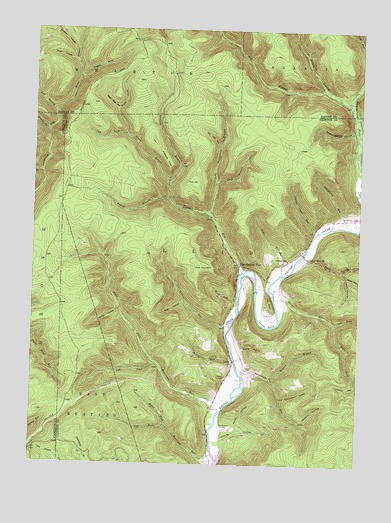
Hammersley Fork, PA USGS Topographic Map
Click on map above to begin viewing in our Map Viewer.

This topographic map contains these locations and features:
Feature Name Type Latitude Longitude GNIS ID View Map
Austin HollowValleyN41.4189°W77.9667°1198344View Map
Baldy HollowValleyN41.3851°W77.9199°1198352View Map
Bear HollowValleyN41.4221°W77.9419°1198370View Map
Bear TrailTrailN41.4726°W77.9397°1206349View Map
Bearfield RunStreamN41.3781°W77.9294°1198383View Map
Beaverdam RunStreamN41.3920°W77.9247°1198393View Map
Beech Bottom HollowValleyN41.4712°W77.8776°1198397View Map
Beech Bottom Natural AreaAreaN41.4667°W77.8830°1201679View Map
Beer Keg HollowValleyN41.4769°W77.9680°1198403View Map
Bell BranchStreamN41.4798°W77.8800°1198405View Map
Bell Branch TrailTrailN41.4856°W77.9144°1198406View Map
Boweyes PointCapeN41.4626°W77.9492°1198467View Map
Bruner BranchStreamN41.3998°W77.9078°1198487View Map
Calhoun BranchStreamN41.4567°W77.9483°1198517View Map
Central SchoolSchoolN41.4342°W77.9022°1198556View Map
Chicken Farm TrailTrailN41.3892°W77.9697°1206353View Map
Cooney HollowValleyN41.4711°W77.9944°1198600View Map
County Line RunStreamN41.4751°W77.8753°1198608View Map
County Line TrailTrailN41.4734°W77.8755°1206341View Map
Daugherty RunStreamN41.4442°W77.8814°1198639View Map
Fork HillSummitN41.4565°W77.9389°1198756View Map
Fork Hill TrailTrailN41.4134°W77.8780°1206346View Map
Gospel Camp ChurchChurchN41.4348°W77.8942°1198815View Map
Greene BranchStreamN41.4567°W77.9483°1198835View Map
Hammersley ForkPopulated PlaceN41.4326°W77.9206°1198856View Map
Hevner RunStreamN41.4165°W77.8836°1198878View Map
Hickory HollowValleyN41.3977°W77.8752°1198879View Map
Hoover HollowValleyN41.3820°W77.9259°1198910View Map
Indian Camp RunStreamN41.4423°W77.8911°1198923View Map
John Summerson BranchStreamN41.4462°W77.9317°1198949View Map
Kates HollowValleyN41.4311°W77.8814°1198962View Map
Kettle Creek State ParkParkN41.3778°W77.9231°1196514View Map
Leeds HollowValleyN41.4292°W77.8794°1199018View Map
Left Branch Lushbaugh RunStreamN41.4765°W77.9919°1199020View Map
Left Branch TrailTrailN41.4026°W77.9697°1206352View Map
Left Fork Bearfield RunStreamN41.3862°W77.9478°1199021View Map
Left Fork Beaverdam RunStreamN41.4045°W77.9511°1199022View Map
Left Fork Green BranchStreamN41.4698°W77.9644°1199025View Map
Left Fork Hevner RunStreamN41.4165°W77.8836°1199026View Map
LeidyPopulated PlaceN41.4053°W77.9225°1204005View Map
Lock BranchStreamN41.4559°W77.9300°1199069View Map
Long HollowValleyN41.4008°W77.8757°1199078View Map
McCoy CemeteryCemeteryN41.4004°W77.9253°1199129View Map
McCoy RunStreamN41.4059°W77.9222°1199130View Map
Nelson BranchStreamN41.4831°W77.8867°1199215View Map
Oxbow BendBendN41.4187°W77.9094°1199265View Map
Page RunStreamN41.4303°W77.9042°1199268View Map
Parker Hollow TrailTrailN41.4801°W77.9567°1206348View Map
Poges HoleValleyN41.4868°W77.9825°1199322View Map
Right Branch Lushbaugh RunStreamN41.4762°W77.9919°1199379View Map
Right Fork Bearfield RunStreamN41.3862°W77.9478°1199380View Map
Right Fork Beaverdam RunStreamN41.4045°W77.9511°1199381View Map
Right Fork Green BranchStreamN41.4698°W77.9644°1199384View Map
Road HollowValleyN41.4339°W77.8937°1199390View Map
Spicewood RunStreamN41.4009°W77.9189°1199574View Map
Stump HollowValleyN41.4083°W77.9189°1199633View Map
Summerson CemeteryCemeteryN41.3862°W77.9253°1199645View Map
Summerson HollowValleyN41.3945°W77.9037°1199646View Map
Tate HollowValleyN41.4907°W77.9845°1199666View Map
The BunkSummitN41.4220°W77.9089°1199675View Map
Trout RunStreamN41.4315°W77.9178°1199695View Map
Trout Run MountainSummitN41.4320°W77.9350°1199696View Map
Trout Run Ridge TrailTrailN41.4667°W77.8997°1206350View Map
Upper Doctor Green TrailTrailN41.4834°W77.9658°1206347View Map
Van Oak HollowValleyN41.4674°W77.9287°1199722View Map
Walters RunStreamN41.4151°W77.9242°1199740View Map
Walters Run TrailTrailN41.4367°W77.9564°1206351View Map
Weed RunStreamN41.4223°W77.9211°1199756View Map
Wheaton HollowValleyN41.3875°W77.8962°1199774View Map
Wheeler HollowValleyN41.4934°W77.9841°1199776View Map
Wykoff BranchStreamN41.4515°W77.9475°1199820View Map

Note: Coordinates in the location and feature list above are referenced to NAD83 datum.


Copyright (C) 2008-2025 Ryan Niemi / Sunset Dynamics ... All Rights Reserved