TopoQuest Logo
Do you find TopoQuest useful?
Help keep TopoQuest running and adding new maps/features by donating!
Bitcoin:  19c7KJd3qBynnjoSw5npx9KScwjBe4ifkT
Litecoin:  LXs6TkuXGGXo1vDsWCkWVdjQX94eUKd6ui
Home View Maps Find Maps Find Places Resources & Links


Sinnemahoning, Pennsylvania Topographic Map

USGS Map Title: Sinnemahoning, PA
USGS Map MRC: 41078C1
DRG (GeoTIFF) Download: o41078c1.tif


Neighboring USGS Topographic Map Quads:


  Cameron, PA  
41078D2
 

  First Fork, PA  
41078D1
 

  Hammersley Fork, PA  
41077D8
 

  Driftwood, PA  
41078C2
 

  Sinnemahoning, PA  
41078C1
 

  Keating, PA  
41077C8
 

  Devils Elbow, PA  
41078B2
 

  Pottersdale, PA  
41078B1
 

  Snow Shoe NW, PA  
41077B8


Map MRC Location:

N42°
W79°
N42°
W78°
H8 H7 H6 H5 H4 H3 H2 H1
G8 G7 G6 G5 G4 G3 G2 G1
F8 F7 F6 F5 F4 F3 F2 F1
E8 E7 E6 E5 E4 E3 E2 E1
D8 D7 D6 D5 D4 D3 D2 D1
C8 C7 C6 C5 C4 C3 C2 C1
B8 B7 B6 B5 B4 B3 B2 B1
A8 A7 A6 A5 A4 A3 A2 A1
N41°
W79°
N41°
W78°

Sinnemahoning, PA USGS 1:24K Topographic Map Preview:
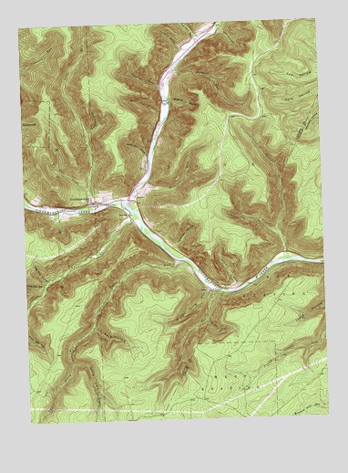
Sinnemahoning, PA USGS Topographic Map
Click on map above to begin viewing in our Map Viewer.

This topographic map contains these locations and features:
Feature Name Type Latitude Longitude GNIS ID View Map
Arksill RunStreamN41.3609°W78.0583°1168386View Map
Board Rock HollowValleyN41.3333°W78.0722°1169918View Map
Bog Ore HollowValleyN41.2946°W78.1165°1169935View Map
Cow HollowValleyN41.3578°W78.0006°1200073View Map
Cut Off TrailTrailN41.2751°W78.0144°1206355View Map
Dark HollowValleyN41.2795°W78.0964°1172933View Map
Ellicott RunStreamN41.3259°W78.0717°1174147View Map
First Fork Sinnemahoning CreekStreamN41.3173°W78.0797°1198732View Map
Grove RunStreamN41.3167°W78.0972°1176281View Map
Guys HollowValleyN41.3727°W78.0408°1176332View Map
JerichoPopulated PlaceN41.3220°W78.0767°1178047View Map
Jerry Lick DraftValleyN41.2684°W78.1059°1192688View Map
Left Branch Montour RunStreamN41.3090°W78.0181°1179134View Map
Left Fork Grove RunStreamN41.3226°W78.0969°1179141View Map
Lick Island RunStreamN41.3692°W78.0486°1179290View Map
Lower Jerry RunStreamN41.2903°W78.0450°1180016View Map
Lower Jerry Run Natural AreaAreaN41.2701°W78.0597°1201822View Map
Middle Jerry RunStreamN41.2903°W78.0450°1181035View Map
Miller Run CemeteryCemeteryN41.3503°W78.0654°1181212View Map
Montour RunStreamN41.2998°W78.0147°1214677View Map
North Fork TrailTrailN41.2678°W78.0197°1206356View Map
Pepper Hill TrailTrailN41.3653°W78.0719°1206759View Map
Pepperhill RunStreamN41.3556°W78.0653°1183573View Map
Pfoutz RunStreamN41.2912°W78.0350°1183649View Map
Poormans DraftValleyN41.3414°W78.0975°1193147View Map
Pumpkin HollowValleyN41.3669°W78.0570°1184492View Map
Quehanna TrailTrailN41.2840°W78.1061°1206688View Map
Quehanna Wild AreaAreaN41.2667°W78.1233°1201680View Map
Rammage HollowValleyN41.3050°W78.0614°1184624View Map
Riddles HollowValleyN41.3513°W78.0628°1185030View Map
Round Island Run TrailTrailN41.2706°W78.0064°1206354View Map
Sinnamahoning Post OfficePost OfficeN41.3181°W78.0940°2772981View Map
Sinnamahoning Volunteer Fire Station 16BuildingN41.3181°W78.0939°2644713View Map
SinnemahoningPopulated PlaceN41.3192°W78.0964°1187723View Map
Sinnemahoning Post Office (historical)Post OfficeN41.3192°W78.0947°1214255View Map
Smoke DraftValleyN41.2811°W78.0493°1187912View Map
Trout Hole RunStreamN41.2926°W78.1167°1189837View Map
Upper Jerry RunStreamN41.3003°W78.0586°1193585View Map
White Oak RunStreamN41.3423°W78.0675°1214678View Map
White RunStreamN41.3426°W78.0669°1191317View Map
Wykoff RunStreamN41.3137°W78.0761°1191825View Map
WysidePopulated PlaceN41.3148°W78.0806°1191851View Map

Note: Coordinates in the location and feature list above are referenced to NAD83 datum.


Copyright (C) 2008-2025 Ryan Niemi / Sunset Dynamics ... All Rights Reserved