TopoQuest Logo
Do you find TopoQuest useful?
Help keep TopoQuest running and adding new maps/features by donating!
Bitcoin:  19c7KJd3qBynnjoSw5npx9KScwjBe4ifkT
Litecoin:  LXs6TkuXGGXo1vDsWCkWVdjQX94eUKd6ui
Home View Maps Find Maps Find Places Resources & Links


Mount Waldo, Maine Topographic Map

USGS Map Title: Mount Waldo, ME
USGS Map MRC: 44068E8
DRG (GeoTIFF) Download: o44068e8.tif


Neighboring USGS Topographic Map Quads:


  East Dixmont, ME  
44069F1
 

  Snow Mountain, ME  
44068F8
 

  Hampden, ME  
44068F7
 

  Brooks East, ME  
44069E1
 

  Mount Waldo, ME  
44068E8
 

  Bucksport, ME  
44068E7
 

  Belfast, ME  
44069D1
 

  Searsport, ME  
44068D8
 

  Castine, ME  
44068D7


Map MRC Location:

N45°
W69°
N45°
W68°
H8 H7 H6 H5 H4 H3 H2 H1
G8 G7 G6 G5 G4 G3 G2 G1
F8 F7 F6 F5 F4 F3 F2 F1
E8 E7 E6 E5 E4 E3 E2 E1
D8 D7 D6 D5 D4 D3 D2 D1
C8 C7 C6 C5 C4 C3 C2 C1
B8 B7 B6 B5 B4 B3 B2 B1
A8 A7 A6 A5 A4 A3 A2 A1
N44°
W69°
N44°
W68°

Mount Waldo, ME USGS 1:24K Topographic Map Preview:
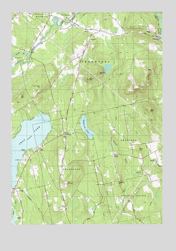
Mount Waldo, ME USGS Topographic Map
Click on map above to begin viewing in our Map Viewer.

This topographic map contains these locations and features:
Feature Name Type Latitude Longitude GNIS ID View Map
Brown CornerPopulated PlaceN44.5406°W68.9150°563045View Map
Clark SchoolSchoolN44.5506°W68.9050°564050View Map
Delaware MountainSummitN44.5890°W68.9280°565019View Map
Dodge CornerPopulated PlaceN44.5445°W68.9773°579244View Map
Downs HillSummitN44.6162°W68.8935°565262View Map
Dutch MountainSummitN44.5854°W68.9356°565441View Map
FrankfortPopulated PlaceN44.6098°W68.8767°566531View Map
Frankfort Elementary SchoolSchoolN44.6091°W68.9334°580839View Map
Halfmoon PondLakeN44.5572°W68.9378°567464View Map
Halfmoon StreamStreamN44.5295°W68.8978°567468View Map
Hedgehog HillSummitN44.5252°W68.9120°567888View Map
Hedgehog MountainSummitN44.5984°W68.9264°567898View Map
Lane BrookStreamN44.5370°W68.8861°569359View Map
Lane CemeteryCemeteryN44.5981°W68.9425°2737058View Map
Lane SchoolSchoolN44.6042°W68.9375°569370View Map
Littlefield BrookStreamN44.6192°W68.9545°570113View Map
Lowe CemeteryCemeteryN44.6062°W68.9760°2737059View Map
Mack MountainSummitN44.5674°W68.8870°570627View Map
Main StreamStreamN44.5370°W68.8861°570669View Map
Meadow BrookStreamN44.6187°W68.9509°571053View Map
Mount EphraimSummitN44.5242°W68.9540°565929View Map
Mount WaldoSummitN44.5807°W68.8969°577781View Map
Nickerson CemeteryCemeteryN44.5196°W68.9895°572164View Map
North Branch Marsh StreamStreamN44.6006°W68.9859°572279View Map
North SearsportPopulated PlaceN44.5540°W68.9561°572407View Map
Oak HillSummitN44.5761°W68.9913°572586View Map
Searsport North Fire StationBuildingN44.5524°W68.9548°2552704View Map
Smith HillSummitN44.5443°W68.8942°575626View Map
Smith PondLakeN44.5036°W68.9964°575632View Map
Spruce PointCapeN44.5437°W68.9870°576156View Map
Swan LakeReservoirN44.5491°W68.9865°576578View Map
Swan Lake DamDamN44.5214°W68.9974°1774043View Map
SwanvillePopulated PlaceN44.5212°W68.9978°576588View Map
Town Farm HillSummitN44.5810°W68.9748°577227View Map
Town of FrankfortCivilN44.5986°W68.9191°582478View Map
WBFB-FM (Ellsworth)TowerN44.5808°W68.8975°582042View Map
West Frankfort Fire Station First RespondersBuildingN44.5926°W68.9553°2553090View Map
West WinterportPopulated PlaceN44.6209°W68.9525°579828View Map
West Winterport ChurchChurchN44.6240°W68.9689°578236View Map
West Winterport DamDamN44.6186°W68.9583°1774557View Map
Wiswell CemeteryCemeteryN44.6132°W68.8847°578615View Map

Note: Coordinates in the location and feature list above are referenced to NAD83 datum.


Copyright (C) 2008-2025 Ryan Niemi / Sunset Dynamics ... All Rights Reserved