TopoQuest Logo
Do you find TopoQuest useful?
Help keep TopoQuest running and adding new maps/features by donating!
Bitcoin:  19c7KJd3qBynnjoSw5npx9KScwjBe4ifkT
Litecoin:  LXs6TkuXGGXo1vDsWCkWVdjQX94eUKd6ui
Home View Maps Find Maps Find Places Resources & Links


Snow Mountain, Maine Topographic Map

USGS Map Title: Snow Mountain, ME
USGS Map MRC: 44068F8
DRG (GeoTIFF) Download: o44068f8.tif


Neighboring USGS Topographic Map Quads:


  Carmel, ME  
44069G1
 

  Hermon, ME  
44068G8
 

  Bangor, ME  
44068G7
 

  East Dixmont, ME  
44069F1
 

  Snow Mountain, ME  
44068F8
 

  Hampden, ME  
44068F7
 

  Brooks East, ME  
44069E1
 

  Mount Waldo, ME  
44068E8
 

  Bucksport, ME  
44068E7


Map MRC Location:

N45°
W69°
N45°
W68°
H8 H7 H6 H5 H4 H3 H2 H1
G8 G7 G6 G5 G4 G3 G2 G1
F8 F7 F6 F5 F4 F3 F2 F1
E8 E7 E6 E5 E4 E3 E2 E1
D8 D7 D6 D5 D4 D3 D2 D1
C8 C7 C6 C5 C4 C3 C2 C1
B8 B7 B6 B5 B4 B3 B2 B1
A8 A7 A6 A5 A4 A3 A2 A1
N44°
W69°
N44°
W68°

Snow Mountain, ME USGS 1:24K Topographic Map Preview:
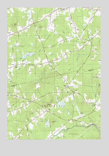
Snow Mountain, ME USGS Topographic Map
Click on map above to begin viewing in our Map Viewer.

This topographic map contains these locations and features:
Feature Name Type Latitude Longitude GNIS ID View Map
Alger PondLakeN44.6698°W68.9166°561167View Map
Brown BrookStreamN44.7287°W68.9356°563027View Map
Burnt SwampSwampN44.7042°W68.9775°563269View Map
Chapman CemeteryCemeteryN44.6953°W68.9898°563849View Map
Clark BrookStreamN44.6381°W68.9053°564019View Map
Clark CemeteryCemeteryN44.6534°W68.9420°564029View Map
Clements BrookStreamN44.6290°W68.9378°564087View Map
Ellingwood CornerPopulated PlaceN44.6751°W68.9184°579288View Map
Ellingwood Corner CemeteryCemeteryN44.6767°W68.9189°2737053View Map
Fred Low HillSummitN44.6498°W68.9672°566547View Map
Hampden CenterPopulated PlaceN44.7490°W68.8867°579384View Map
Hampden Country ClubLocaleN44.7459°W68.9306°1913568View Map
Kelly MountainSummitN44.7338°W68.9925°569080View Map
Longfellow SchoolSchoolN44.7478°W68.8767°570329View Map
Nealeys CornerPopulated PlaceN44.6984°W68.9445°579549View Map
Neallys Corner CemeteryCemeteryN44.7017°W68.9320°1913725View Map
Neallys Corner Methodist ChurchChurchN44.6984°W68.9467°1913726View Map
Newburgh Community LibraryBuildingN44.7313°W68.9798°2738526View Map
Newburgh Elementary SchoolSchoolN44.7313°W68.9799°577828View Map
Newburgh VillagePopulated PlaceN44.6967°W68.9789°579553View Map
Newburgh Volunteer Fire StationBuildingN44.6968°W68.9802°2553158View Map
Oak HillSummitN44.6717°W68.9090°572589View Map
Partridge HillSummitN44.6419°W68.9394°573031View Map
Perkins CemeteryCemeteryN44.6659°W68.9519°2737060View Map
Pickard HillSummitN44.7314°W68.9571°573279View Map
Snow MountainSummitN44.6579°W68.9472°575682View Map
Town of HampdenCivilN44.7350°W68.8896°582508View Map
Town of WinterportCivilN44.6584°W68.9119°582822View Map
Twining CemeteryCemeteryN44.6843°W68.8806°577491View Map
West HampdenPopulated PlaceN44.7492°W68.9270°579818View Map
West Hampden Baptist ChurchChurchN44.7487°W68.9292°1913976View Map
Whites CornerPopulated PlaceN44.6612°W68.9659°578391View Map
Winterport StationLocaleN44.6565°W68.8817°578608View Map

Note: Coordinates in the location and feature list above are referenced to NAD83 datum.


Copyright (C) 2008-2024 Ryan Niemi / Sunset Dynamics ... All Rights Reserved