TopoQuest Logo
Do you find TopoQuest useful?
Help keep TopoQuest running and adding new maps/features by donating!
Bitcoin:  19c7KJd3qBynnjoSw5npx9KScwjBe4ifkT
Litecoin:  LXs6TkuXGGXo1vDsWCkWVdjQX94eUKd6ui
Home View Maps Find Maps Find Places Resources & Links


Greensboro, Georgia Topographic Map

USGS Map Title: Greensboro, GA
USGS Map MRC: 33083E2
DRG (GeoTIFF) Download: o33083e2.tif


Neighboring USGS Topographic Map Quads:


  Greshamville, GA  
33083F3
 

  Penfield, GA  
33083F2
 

  Woodville, GA  
33083F1
 

  Buckhead, GA  
33083E3
 

  Greensboro, GA  
33083E2
 

  Union Point, GA  
33083E1
 

  Harmony, GA  
33083D3
 

  Liberty, GA  
33083D2
 

  White Plains, GA  
33083D1


Map MRC Location:

N34°
W84°
N34°
W83°
H8 H7 H6 H5 H4 H3 H2 H1
G8 G7 G6 G5 G4 G3 G2 G1
F8 F7 F6 F5 F4 F3 F2 F1
E8 E7 E6 E5 E4 E3 E2 E1
D8 D7 D6 D5 D4 D3 D2 D1
C8 C7 C6 C5 C4 C3 C2 C1
B8 B7 B6 B5 B4 B3 B2 B1
A8 A7 A6 A5 A4 A3 A2 A1
N33°
W84°
N33°
W83°

Greensboro, GA USGS 1:24K Topographic Map Preview:
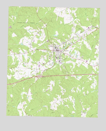
Greensboro, GA USGS Topographic Map
Click on map above to begin viewing in our Map Viewer.

This topographic map contains these locations and features:
Feature Name Type Latitude Longitude GNIS ID View Map
Allens Trailer ParkPopulated PlaceN33.5690°W83.1888°348643View Map
Anita White Carson Middle SchoolSchoolN33.5674°W83.1826°348673View Map
Antioch ChurchChurchN33.5968°W83.2460°348645View Map
Antioch ChurchChurchN33.5965°W83.2463°330658View Map
Ayers CemeteryCemeteryN33.5057°W83.2479°326982View Map
Beaverdam CreekStreamN33.6012°W83.2443°354518View Map
Bethel ChurchChurchN33.5057°W83.1465°327083View Map
Boswell HospitalHospitalN33.5724°W83.1732°354814View Map
Boswell LakeReservoirN33.5578°W83.2064°339049View Map
Boswell Lake DamDamN33.5568°W83.2065°339048View Map
Bowden CreekStreamN33.5240°W83.1524°327199View Map
Cedar Grove School (historical)SchoolN33.5707°W83.2399°348654View Map
Cemetery HillSummitN33.5815°W83.1813°348655View Map
City of GreensboroCivilN33.5678°W83.1877°2403744View Map
Cold Springs Hunt CampLocaleN33.6143°W83.2390°330659View Map
Corry Junior High SchoolSchoolN33.5635°W83.1785°355326View Map
Darwin SubdivisionPopulated PlaceN33.5515°W83.1721°348661View Map
Dogwood Plaza Shopping CenterLocaleN33.5765°W83.1888°348662View Map
Enon ChurchChurchN33.5043°W83.1415°327768View Map
Exit 53CrossingN33.5626°W83.2054°1705003View Map
Fellowship TabernacleChurchN33.5818°W83.2185°327808View Map
First Baptist ChurchChurchN33.5743°W83.1832°348666View Map
Greene CountyCivilN33.5788°W83.1667°348672View Map
Greene County CourthouseBuildingN33.5762°W83.1824°348674View Map
Greene County Emergency Medical ServicesBuildingN33.5630°W83.1840°2625459View Map
Greene County High SchoolSchoolN33.5632°W83.1827°348677View Map
Greene County Industrial ParkLocaleN33.5612°W83.1915°348675View Map
Greene County JailBuildingN33.5672°W83.1913°2734090View Map
Greene County LibraryBuildingN33.5687°W83.1832°348676View Map
Greene County Regional AirportAirportN33.5961°W83.1387°351780View Map
Greene County Sheriff's OfficeBuildingN33.5673°W83.1913°2733630View Map
GreensboroPopulated PlaceN33.5757°W83.1824°356104View Map
Greensboro City CemeteryCemeteryN33.5812°W83.1813°1705407View Map
Greensboro City HallBuildingN33.5773°W83.1827°348678View Map
Greensboro Commercial Historic DistrictParkN33.5760°W83.1827°348679View Map
Greensboro DivisionCivilN33.5338°W83.1961°1936296View Map
Greensboro Elementary SchoolSchoolN33.5638°W83.1784°348682View Map
Greensboro LakeReservoirN33.5948°W83.1553°328005View Map
Greensboro Male and Female Academy (historical)SchoolN33.5804°W83.1818°348680View Map
Greensboro Police DepartmentBuildingN33.5730°W83.1752°2733501View Map
Greensboro Post OfficePost OfficeN33.5757°W83.1829°348681View Map
Greensboro Volunteer Fire DepartmentBuildingN33.5742°W83.1750°2603725View Map
Greensboro Water Reservoir DamDamN33.5785°W83.1732°339056View Map
Greensboro Water Treatment StationLocaleN33.5707°W83.2335°330657View Map
Hutchinson ChurchChurchN33.5046°W83.1874°328267View Map
Interchange Fifty-threeCrossingN33.5460°W83.2054°330656View Map
Lassiter LakeReservoirN33.5973°W83.2204°339053View Map
Lassiter Lake DamDamN33.5985°W83.2215°339052View Map
Lenore Church (historical)ChurchN33.5101°W83.1652°348685View Map
Lick Skillet LakeReservoirN33.5822°W83.2307°339051View Map
Lick Skillet Lake DamDamN33.5818°W83.2315°339050View Map
Macedonia ChurchChurchN33.6043°W83.1354°328677View Map
Margarets Grove ChurchChurchN33.5199°W83.2063°317689View Map
Meadow Crest School (historical)SchoolN33.5496°W83.2110°348691View Map
North Street-East Street Historic DistrictParkN33.5773°W83.1802°348698View Map
Oak Grove School (historical)SchoolN33.6032°W83.1293°348700View Map
Oliver CreekStreamN33.5332°W83.1471°329097View Map
Parker LakeReservoirN33.5927°W83.1854°336435View Map
Parker Lake DamDamN33.5935°W83.1865°336434View Map
Phelps LakeReservoirN33.5789°W83.1719°329189View Map
Robinson ParkParkN33.5729°W83.1754°348709View Map
Rock Chapel (historical)ChurchN33.5804°W83.1818°348710View Map
Rocky BranchStreamN33.5018°W83.2260°329484View Map
Roper LakeReservoirN33.5458°W83.1532°339488View Map
Roper Lake DamDamN33.5451°W83.1532°339487View Map
Rush CreekStreamN33.6157°W83.1440°329546View Map
Sanders Mill (historical)LocaleN33.5612°W83.1393°348716View Map
Small Agresearch LakeReservoirN33.5696°W83.1547°339047View Map
Small Agresearch Lake DamDamN33.5685°W83.1549°339046View Map
South Street-Broad Street-Main Street-Laurel Street Historic DistrictParkN33.5751°W83.1857°348740View Map
South Walnut Street Historic DistrictParkN33.5751°W83.1813°348721View Map
Springfield ChurchChurchN33.5687°W83.1779°329800View Map
ThurstonPopulated PlaceN33.5540°W83.2102°348727View Map
Town CreekStreamN33.5435°W83.2221°330026View Map
VeazeyPopulated PlaceN33.5046°W83.1410°333322View Map
Walker CemeteryCemeteryN33.5085°W83.1865°1705440View Map
Walker ChurchChurchN33.5085°W83.1868°330139View Map
WDDK-FM (Greensboro)TowerN33.5762°W83.1740°352702View Map
Webb LakeReservoirN33.5837°W83.1649°339490View Map
Webb Lake DamDamN33.5818°W83.1665°339489View Map
Webb Trailer ParkPopulated PlaceN33.5865°W83.1671°348732View Map
Wesley Chapel CemeteryCemeteryN33.5604°W83.1254°1705442View Map
Wrightsville ChurchChurchN33.5004°W83.2188°330388View Map

Note: Coordinates in the location and feature list above are referenced to NAD83 datum.


Copyright (C) 2008-2025 Ryan Niemi / Sunset Dynamics ... All Rights Reserved