TopoQuest Logo
Do you find TopoQuest useful?
Help keep TopoQuest running and adding new maps/features by donating!
Bitcoin:  19c7KJd3qBynnjoSw5npx9KScwjBe4ifkT
Litecoin:  LXs6TkuXGGXo1vDsWCkWVdjQX94eUKd6ui
Home View Maps Find Maps Find Places Resources & Links


Rives, Tennessee Topographic Map

USGS Map Title: Rives, TN
USGS Map MRC: 36089C1
DRG (GeoTIFF) Download: o36089c1.tif


Neighboring USGS Topographic Map Quads:


  Clayton, TN  
36089D2
 

  Union City, TN  
36089D1
 

  Harris, TN  
36088D8
 

  Obion, TN  
36089C2
 

  Rives, TN  
36089C1
 

  Gardner, TN  
36088C8
 

  Trimble, TN  
36089B2
 

  Kenton, TN  
36089B1
 

  Rutherford, TN  
36088B8


Map MRC Location:

N37°
W90°
N37°
W89°
H8 H7 H6 H5 H4 H3 H2 H1
G8 G7 G6 G5 G4 G3 G2 G1
F8 F7 F6 F5 F4 F3 F2 F1
E8 E7 E6 E5 E4 E3 E2 E1
D8 D7 D6 D5 D4 D3 D2 D1
C8 C7 C6 C5 C4 C3 C2 C1
B8 B7 B6 B5 B4 B3 B2 B1
A8 A7 A6 A5 A4 A3 A2 A1
N36°
W90°
N36°
W89°

Rives, TN USGS 1:24K Topographic Map Preview:
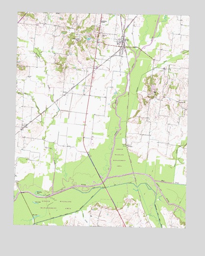
Rives, TN USGS Topographic Map
Click on map above to begin viewing in our Map Viewer.

This topographic map contains these locations and features:
Feature Name Type Latitude Longitude GNIS ID View Map
Big LakeLakeN36.2549°W89.1095°1277336View Map
Botts DamDamN36.3601°W89.0717°1302540View Map
Botts LakeReservoirN36.3601°W89.0733°1302541View Map
Cane CreekStreamN36.2765°W89.0101°1279521View Map
Central ChurchChurchN36.3242°W89.0023°1280163View Map
Commissioner District 3CivilN36.3147°W89.0467°2464183View Map
CrockettPopulated PlaceN36.2981°W89.0428°1281634View Map
Cypress CreekStreamN36.3115°W89.0492°1281933View Map
Davidson CreekStreamN36.2765°W89.0870°1282106View Map
Gooch Wildlife Management AreaParkN36.2584°W89.0834°1320459View Map
Grass CreekStreamN36.2601°W89.0765°1285869View Map
Hoosier CreekStreamN36.3498°W89.0384°1288258View Map
Horseshoe LakeLakeN36.2681°W89.1059°1288450View Map
Long LakeLakeN36.2631°W89.1094°1291985View Map
McCutchen HeightsPopulated PlaceN36.3706°W89.0648°1293234View Map
MoffattPopulated PlaceN36.3267°W89.0912°1315528View Map
Mud CreekStreamN36.2773°W89.0234°1295007View Map
North Fork Obion RiverStreamN36.2787°W89.0578°1295906View Map
Pleasant HillPopulated PlaceN36.3626°W89.0792°1647545View Map
Pleasant Hill CemeteryCemeteryN36.3587°W89.0803°1326725View Map
Pleasant Hill ChurchChurchN36.3592°W89.0809°1297881View Map
PolkPopulated PlaceN36.3081°W89.1178°1298053View Map
RivesPopulated PlaceN36.3556°W89.0481°1299539View Map
Rives Elementary SchoolSchoolN36.3576°W89.0520°1320491View Map
Rives Post OfficePost OfficeN36.3554°W89.0466°1651481View Map
Rives Volunteer Fire DepartmentBuildingN36.3560°W89.0468°2653834View Map
Rutherford Fork Obion RiverStreamN36.2740°W89.0212°1300357View Map
Sardis CemeteryCemeteryN36.3267°W89.1223°1300791View Map
Stovall CemeteryCemeteryN36.3284°W89.0245°1271551View Map
Town of RivesCivilN36.3564°W89.0495°2407227View Map
Troy CreekStreamN36.3062°W89.1023°1272919View Map
Turner LakeReservoirN36.3320°W89.0254°1302515View Map
Turner Lake DamDamN36.3351°W89.0251°1302516View Map
West Hill CemeteryCemeteryN36.3620°W89.0634°1274201View Map

Note: Coordinates in the location and feature list above are referenced to NAD83 datum.


Copyright (C) 2008-2024 Ryan Niemi / Sunset Dynamics ... All Rights Reserved