TopoQuest Logo
Do you find TopoQuest useful?
Help keep TopoQuest running and adding new maps/features by donating!
Bitcoin:  19c7KJd3qBynnjoSw5npx9KScwjBe4ifkT
Litecoin:  LXs6TkuXGGXo1vDsWCkWVdjQX94eUKd6ui
Home View Maps Find Maps Find Places Resources & Links


Harrisburg, Alabama Topographic Map

USGS Map Title: Harrisburg, AL
USGS Map MRC: 32087G2
DRG (GeoTIFF) Download: o32087g2.tif


Neighboring USGS Topographic Map Quads:


  Pondville, AL  
32087H3
 

  Centreville West, AL  
32087H2
 

  Centreville East, AL  
32087H1
 

  Heiberger, AL  
32087G3
 

  Harrisburg, AL  
32087G2
 

  Oakmulgee, AL  
32087G1
 

  Marion North, AL  
32087F3
 

  Sprott, AL  
32087F2
 

  Buck Creek, AL  
32087F1


Map MRC Location:

N33°
W88°
N33°
W87°
H8 H7 H6 H5 H4 H3 H2 H1
G8 G7 G6 G5 G4 G3 G2 G1
F8 F7 F6 F5 F4 F3 F2 F1
E8 E7 E6 E5 E4 E3 E2 E1
D8 D7 D6 D5 D4 D3 D2 D1
C8 C7 C6 C5 C4 C3 C2 C1
B8 B7 B6 B5 B4 B3 B2 B1
A8 A7 A6 A5 A4 A3 A2 A1
N32°
W88°
N32°
W87°

Harrisburg, AL USGS 1:24K Topographic Map Preview:
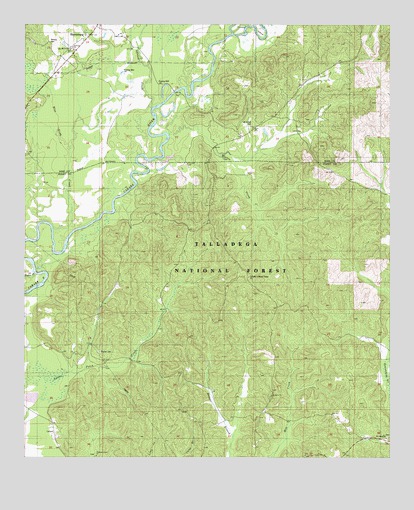
Harrisburg, AL USGS Topographic Map
Click on map above to begin viewing in our Map Viewer.

This topographic map contains these locations and features:
Feature Name Type Latitude Longitude GNIS ID View Map
AbercrombiePopulated PlaceN32.8487°W87.1650°150979View Map
AdlerPopulated PlaceN32.7632°W87.1683°162643View Map
Affonee CreekStreamN32.8685°W87.1847°159053View Map
Antioch African Methodist Episcopal ChurchChurchN32.8690°W87.2336°161881View Map
Barnett School (historical)SchoolN32.7604°W87.1806°163024View Map
Blue Girth CreekStreamN32.8173°W87.2419°159210View Map
Bonnet CreekStreamN32.7562°W87.1789°162652View Map
Cahaba Lookout TowerTowerN32.8021°W87.1731°162655View Map
Cahaba Picnic AreaParkN32.8296°W87.1858°162656View Map
Ebenezer (historical)LocaleN32.8340°W87.1714°162659View Map
LevertPopulated PlaceN32.7593°W87.2414°159927View Map
Levert School (historical)SchoolN32.7607°W87.2408°163027View Map
Lilly Hill ChurchChurchN32.8682°W87.2356°161903View Map
Mount Gilead Baptist ChurchChurchN32.8457°W87.1722°161898View Map
Mount Gilead CemeteryCemeteryN32.8460°W87.1722°161905View Map
Mount Gilead CemeteryCemeteryN32.7562°W87.1253°163018View Map
Mount Gilead ChurchChurchN32.7557°W87.1261°162674View Map
Mount Gilead School (historical)SchoolN32.7557°W87.1278°163030View Map
Mount Olive Baptist ChurchChurchN32.7679°W87.1656°162677View Map
Payne Chapel Methodist Church (historical)ChurchN32.7829°W87.2264°163017View Map
Paynes CemeteryCemeteryN32.7807°W87.2244°162683View Map
Perkins CemeteryCemeteryN32.8696°W87.2417°161907View Map
Pleasant Grove ChurchChurchN32.7507°W87.2256°162688View Map
Stewart CemeteryCemeteryN32.7635°W87.1964°163019View Map
Taylor CreekStreamN32.8046°W87.2458°160721View Map

Note: Coordinates in the location and feature list above are referenced to NAD83 datum.


Copyright (C) 2008-2025 Ryan Niemi / Sunset Dynamics ... All Rights Reserved