TopoQuest Logo
Do you find TopoQuest useful?
Help keep TopoQuest running and adding new maps/features by donating!
Bitcoin:  19c7KJd3qBynnjoSw5npx9KScwjBe4ifkT
Litecoin:  LXs6TkuXGGXo1vDsWCkWVdjQX94eUKd6ui
Home View Maps Find Maps Find Places Resources & Links


Tarry, Arkansas Topographic Map

USGS Map Title: Tarry, AR
USGS Map MRC: 34091A7
DRG (GeoTIFF) Download: o34091a7.tif


Neighboring USGS Topographic Map Quads:


  Ladd, AR  
34091B8
 

  Moscow, AR  
34091B7
 

  Cornerstone, AR  
34091B6
 

  Pinebergen, AR  
34091A8
 

  Tarry, AR  
34091A7
 

  Grady, AR  
34091A6
 

  Glendale, AR  
33091H8
 

  Star City, AR  
33091H7
 

  Avery, AR  
33091H6


Map MRC Location:

N35°
W92°
N35°
W91°
H8 H7 H6 H5 H4 H3 H2 H1
G8 G7 G6 G5 G4 G3 G2 G1
F8 F7 F6 F5 F4 F3 F2 F1
E8 E7 E6 E5 E4 E3 E2 E1
D8 D7 D6 D5 D4 D3 D2 D1
C8 C7 C6 C5 C4 C3 C2 C1
B8 B7 B6 B5 B4 B3 B2 B1
A8 A7 A6 A5 A4 A3 A2 A1
N34°
W92°
N34°
W91°

Tarry, AR USGS 1:24K Topographic Map Preview:
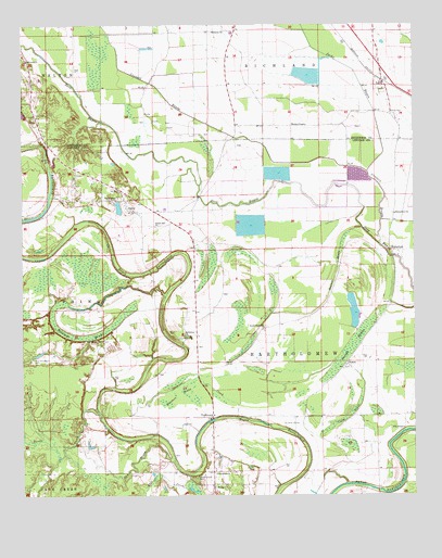
Tarry, AR USGS Topographic Map
Click on map above to begin viewing in our Map Viewer.

This topographic map contains these locations and features:
Feature Name Type Latitude Longitude GNIS ID View Map
Atkinson Ford BridgeBridgeN34.0201°W91.8146°60278View Map
Beaver BrakeStreamN34.0712°W91.7665°46260View Map
Belmont ChurchChurchN34.1234°W91.8146°46375View Map
Bethlehem Baptist ChurchChurchN34.0429°W91.8237°76323View Map
Bright Star ChurchChurchN34.0718°W91.8324°46956View Map
Bright Star School (historical)SchoolN34.0715°W91.8326°64044View Map
Clowers LakeReservoirN34.0784°W91.8418°80439View Map
Clowers Lake DamDamN34.0784°W91.8418°80438View Map
Coles BrakeSwampN34.0229°W91.7716°47920View Map
Cousart BayouStreamN34.0665°W91.7607°76692View Map
Daniels ChapelChurchN34.0984°W91.7843°48350View Map
Dry BayouGutN34.0051°W91.8454°48616View Map
Flat CreekStreamN34.0001°W91.8199°49101View Map
Folk ChapelChurchN34.0179°W91.7535°49147View Map
Goosby BranchStreamN34.0101°W91.8637°49509View Map
Hastings BrakeSwampN34.0425°W91.8525°49931View Map
Hunters BrakeSwampN34.0269°W91.8264°50417View Map
Jacks BayouStreamN34.0862°W91.7646°50548View Map
Jefferson ChurchChurchN34.1154°W91.8740°50606View Map
Marzel CemeteryCemeteryN34.1018°W91.7579°51723View Map
Mount Nebo Missionary Baptist ChurchChurchN34.0023°W91.8140°78893View Map
NeboPopulated PlaceN34.0029°W91.8143°58243View Map
Nebo School (historical)SchoolN34.0029°W91.8137°64075View Map
New Macedonia CemeteryCemeteryN34.0356°W91.8718°52719View Map
New Macedonia ChurchChurchN34.0415°W91.8493°52720View Map
Oak Grove Missionary Baptist Church (historical)ChurchN34.0051°W91.8199°60279View Map
PhenixPopulated PlaceN34.0334°W91.7710°58354View Map
Richardson ChurchChurchN34.0748°W91.7560°54015View Map
Richland Chapel (historical)ChurchN34.0726°W91.7571°64089View Map
Shady Grove ChurchChurchN34.0787°W91.8465°54708View Map
Sneeds BrakeSwampN34.0390°W91.7707°54980View Map
Sneeds ChurchChurchN34.0357°W91.7710°64095View Map
Sneeds School (historical)SchoolN34.0454°W91.7621°64096View Map
Southeast Volunteer Fire DepartmentBuildingN34.1078°W91.8723°2117149View Map
Spencer CreekStreamN34.0209°W91.8071°78424View Map
Sweet Home ChurchChurchN34.0445°W91.7982°55390View Map
TamoPopulated PlaceN34.1104°W91.7593°78522View Map
TarryPopulated PlaceN34.0759°W91.8415°55438View Map
Township of BartholomewCivilN34.0290°W91.7785°66820View Map
Turtle CreekStreamN34.0207°W91.8504°55749View Map
White Church CemeteryCemeteryN34.0048°W91.8198°78745View Map
WhitefieldPopulated PlaceN34.0645°W91.7568°58872View Map
YorktownPopulated PlaceN34.0209°W91.8168°56609View Map
Yorktown First Baptist ChurchChurchN34.0057°W91.8137°78826View Map
Yorktown Post OfficePost OfficeN34.0214°W91.8159°2781913View Map

Note: Coordinates in the location and feature list above are referenced to NAD83 datum.


Copyright (C) 2008-2024 Ryan Niemi / Sunset Dynamics ... All Rights Reserved