TopoQuest Logo
Do you find TopoQuest useful?
Help keep TopoQuest running and adding new maps/features by donating!
Bitcoin:  19c7KJd3qBynnjoSw5npx9KScwjBe4ifkT
Litecoin:  LXs6TkuXGGXo1vDsWCkWVdjQX94eUKd6ui
Home View Maps Find Maps Find Places Resources & Links


Harwood, Missouri Topographic Map

USGS Map Title: Harwood, MO
USGS Map MRC: 37094H2
DRG (GeoTIFF) Download: o37094h2.tif


Neighboring USGS Topographic Map Quads:


  Rich Hill, MO  
38094A3
 

  Papinville, MO  
38094A2
 

  Rockville, MO  
38094A1
 

  Horton, MO  
37094H3
 

  Harwood, MO  
37094H2
 

  El Dorado Springs North, MO  
37094H1
 

  Nevada, MO  
37094G3
 

  Dederick, MO  
37094G2
 

  El Dorado Springs South, MO  
37094G1


Map MRC Location:

N38°
W95°
N38°
W94°
H8 H7 H6 H5 H4 H3 H2 H1
G8 G7 G6 G5 G4 G3 G2 G1
F8 F7 F6 F5 F4 F3 F2 F1
E8 E7 E6 E5 E4 E3 E2 E1
D8 D7 D6 D5 D4 D3 D2 D1
C8 C7 C6 C5 C4 C3 C2 C1
B8 B7 B6 B5 B4 B3 B2 B1
A8 A7 A6 A5 A4 A3 A2 A1
N37°
W95°
N37°
W94°

Harwood, MO USGS 1:24K Topographic Map Preview:
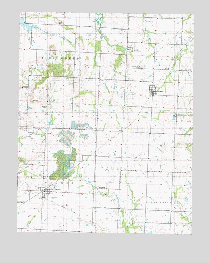
Harwood, MO USGS Topographic Map
Click on map above to begin viewing in our Map Viewer.

This topographic map contains these locations and features:
Feature Name Type Latitude Longitude GNIS ID View Map
Bethany CemeteryCemeteryN37.9461°W94.2302°714011View Map
Blue Mound School (historical)SchoolN37.9931°W94.2416°748336View Map
City of WalkerCivilN37.8989°W94.2306°2397176View Map
Coal CreekStreamN37.9864°W94.1916°716029View Map
Coal Creek School (historical)SchoolN37.9773°W94.1961°748347View Map
Covington DamDamN37.8750°W94.1552°763088View Map
Covington LakeReservoirN37.8753°W94.1551°763089View Map
Fair HavenPopulated PlaceN37.9764°W94.1733°729884View Map
Fair Haven City ParkParkN37.9798°W94.1724°748264View Map
Fair Haven School (historical)SchoolN37.9789°W94.1697°746143View Map
Green Mound CemeteryCemeteryN37.9695°W94.1638°758434View Map
HandleyPopulated PlaceN37.8823°W94.1974°740902View Map
HarwoodPopulated PlaceN37.9561°W94.1544°719195View Map
Harwood Post OfficePost OfficeN37.9562°W94.1531°2782809View Map
Harwood School (historical)SchoolN37.9523°W94.1541°746142View Map
Howard School (historical)SchoolN37.9573°W94.2443°748383View Map
Living Faith CemeteryCemeteryN37.9017°W94.1924°748262View Map
Living Faith ChurchChurchN37.9009°W94.1924°748263View Map
Living Faith Mennonite SchoolSchoolN37.9017°W94.2349°748265View Map
Lowe School (historical)SchoolN37.9095°W94.1397°748404View Map
Moss School (historical)SchoolN37.9478°W94.2019°748414View Map
Mound CemeteryCemeteryN37.9081°W94.2499°748415View Map
Mount Vernon CemeteryCemeteryN37.8878°W94.1420°748261View Map
Mount Vernon ChurchChurchN37.8881°W94.1419°722912View Map
Northeast Vernon County R-1 High SchoolSchoolN37.8969°W94.2289°746144View Map
Pepper HillSummitN37.9936°W94.2199°724221View Map
Robinson School (historical)SchoolN37.9684°W94.1355°748446View Map
Township of Blue MoundCivilN37.9903°W94.2283°767480View Map
Township of WalkerCivilN37.8910°W94.2330°767496View Map
Village of HarwoodCivilN37.9567°W94.1539°2398263View Map
WalkerPopulated PlaceN37.8986°W94.2322°728253View Map
Walker Police DepartmentBuildingN37.8987°W94.2302°2752390View Map
Walker Post OfficePost OfficeN37.8983°W94.2313°2779509View Map
Walker Rural Fire DepartmentBuildingN37.8978°W94.2319°2620401View Map

Note: Coordinates in the location and feature list above are referenced to NAD83 datum.


Copyright (C) 2008-2024 Ryan Niemi / Sunset Dynamics ... All Rights Reserved