TopoQuest Logo
Do you find TopoQuest useful?
Help keep TopoQuest running and adding new maps/features by donating!
Bitcoin:  19c7KJd3qBynnjoSw5npx9KScwjBe4ifkT
Litecoin:  LXs6TkuXGGXo1vDsWCkWVdjQX94eUKd6ui
Home View Maps Find Maps Find Places Resources & Links


Papinville, Missouri Topographic Map

USGS Map Title: Papinville, MO
USGS Map MRC: 38094A2
DRG (GeoTIFF) Download: o38094a2.tif


Neighboring USGS Topographic Map Quads:


  Butler South, MO  
38094B3
 

  Pleasant Gap, MO  
38094B2
 

  Appleton City, MO  
38094B1
 

  Rich Hill, MO  
38094A3
 

  Papinville, MO  
38094A2
 

  Rockville, MO  
38094A1
 

  Horton, MO  
37094H3
 

  Harwood, MO  
37094H2
 

  El Dorado Springs North, MO  
37094H1


Map MRC Location:

N39°
W95°
N39°
W94°
H8 H7 H6 H5 H4 H3 H2 H1
G8 G7 G6 G5 G4 G3 G2 G1
F8 F7 F6 F5 F4 F3 F2 F1
E8 E7 E6 E5 E4 E3 E2 E1
D8 D7 D6 D5 D4 D3 D2 D1
C8 C7 C6 C5 C4 C3 C2 C1
B8 B7 B6 B5 B4 B3 B2 B1
A8 A7 A6 A5 A4 A3 A2 A1
N38°
W95°
N38°
W94°

Papinville, MO USGS 1:24K Topographic Map Preview:
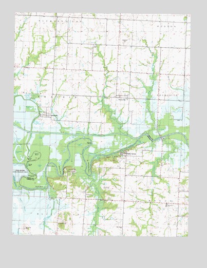
Papinville, MO USGS Topographic Map
Click on map above to begin viewing in our Map Viewer.

This topographic map contains these locations and features:
Feature Name Type Latitude Longitude GNIS ID View Map
Apple Garth BendBendN38.0328°W94.2352°713360View Map
Beasley BendBendN38.0367°W94.2161°713831View Map
Belvoir BluffsCliffN38.0444°W94.1799°713939View Map
Belvoir School (historical)SchoolN38.0377°W94.1704°748334View Map
Bennett LakeLakeN38.0711°W94.2378°713951View Map
Blue MoundSummitN38.0059°W94.2147°729845View Map
Blue Mound Baptist ChurchChurchN38.0048°W94.1722°748247View Map
Breckenridge AirportAirportN38.1145°W94.1755°2679380View Map
Burras BendBendN38.0384°W94.2394°715098View Map
Camm BendBendN38.0439°W94.2319°715237View Map
Carrico LakeLakeN38.0543°W94.2319°715431View Map
Church of ChristChurchN38.0361°W94.2105°748245View Map
Church of IsraelChurchN38.0367°W94.2105°748244View Map
Collins LakeLakeN38.0455°W94.1944°739505View Map
Collins ShoalsBarN38.0473°W94.2005°739504View Map
Coyle BendBendN38.0386°W94.2219°716437View Map
East Cresap RanchLocaleN38.0034°W94.2408°717270View Map
Fairmont School (historical)SchoolN38.0870°W94.1294°748358View Map
Fix PondLakeN38.0587°W94.1443°717968View Map
Flat Rock CemeteryCemeteryN38.0228°W94.2002°748246View Map
Flat Rock School (historical)SchoolN38.0220°W94.1988°748362View Map
Garrison and Westfall CemeteryCemeteryN38.0272°W94.1813°748241View Map
German Reformed Church (historical)ChurchN38.1073°W94.1949°748368View Map
Grant PondLakeN38.0438°W94.1911°718706View Map
Green Lawn CemeteryCemeteryN38.0172°W94.1402°718824View Map
Halley BluffsCliffN38.0364°W94.2138°729898View Map
Halley Bluffs ChurchChurchN38.0303°W94.2122°746137View Map
Hammer HillSummitN38.1092°W94.1733°719047View Map
Happy Hill Church of GodChurchN38.1245°W94.2363°748243View Map
Helem LakeLakeN38.0391°W94.2327°719346View Map
Hirni SloughStreamN38.0573°W94.2157°719636View Map
Hog SloughStreamN38.0273°W94.2244°719683View Map
Horseshoe LakeLakeN38.0413°W94.2459°719865View Map
Indian SpringsPopulated PlaceN38.0450°W94.1702°748242View Map
Kineberger Lake (historical)LakeN38.0642°W94.2394°748393View Map
Krull PondsLakeN38.0761°W94.2361°720703View Map
Ladies BranchStreamN38.0348°W94.1944°729914View Map
Little Osage RiverStreamN38.0275°W94.2441°474560View Map
Logan LakeLakeN38.0511°W94.2041°721423View Map
Marais des Cygnes Drainage DitchCanalN38.0567°W94.1999°758439View Map
Marais des Cygnes RiverStreamN38.0275°W94.2441°477714View Map
Maus CemeteryCemeteryN38.0403°W94.1452°721991View Map
Maus LakeLakeN38.0539°W94.1605°721992View Map
McKenzie CreekStreamN38.0567°W94.1402°722138View Map
Mission Branch School (historical)SchoolN38.0945°W94.2497°748411View Map
Moore BendBendN38.0528°W94.1972°722562View Map
Mosley BendBendN38.0448°W94.2380°722673View Map
Number 1 Bridge (historical)BridgeN38.0573°W94.1791°755338View Map
Number 2 Bridge (historical)BridgeN38.0573°W94.2241°755340View Map
Number 3 Bridge (historical)BridgeN38.0578°W94.2372°755341View Map
Old Harmony Mission SiteLocaleN38.0848°W94.2458°723754View Map
Papinsville School (historical)SchoolN38.0670°W94.2302°746465View Map
PapinvillePopulated PlaceN38.0673°W94.2269°729952View Map
Pecan SloughStreamN38.0261°W94.2466°724164View Map
Prairie CityPopulated PlaceN38.0789°W94.1747°724829View Map
Prairie City CemeteryCemeteryN38.0847°W94.1766°2740265View Map
Prairie City School (historical)SchoolN38.0786°W94.1747°746466View Map
Prairie Lake ClubLocaleN38.0511°W94.2466°724870View Map
Raps PondLakeN38.0472°W94.1855°725107View Map
Rich Valley School (historical)SchoolN38.1203°W94.1419°748445View Map
Rocky Ford (historical)Populated PlaceN38.0359°W94.1947°748448View Map
Schapeler BendBendN38.0370°W94.1963°726095View Map
Seelinger School (historical)SchoolN38.1011°W94.2119°746467View Map
Shaw BranchStreamN38.0573°W94.1574°726287View Map
South BendBendN38.0284°W94.2283°726698View Map
Steuck PondsLakeN38.0628°W94.2340°727082View Map
Towne School (historical)SchoolN38.0053°W94.1719°748465View Map
Township of PrairieCivilN38.0761°W94.2232°766305View Map
Willow BranchStreamN38.0567°W94.1688°728929View Map

Note: Coordinates in the location and feature list above are referenced to NAD83 datum.


Copyright (C) 2008-2025 Ryan Niemi / Sunset Dynamics ... All Rights Reserved