TopoQuest Logo
Do you find TopoQuest useful?
Help keep TopoQuest running and adding new maps/features by donating!
Bitcoin:  19c7KJd3qBynnjoSw5npx9KScwjBe4ifkT
Litecoin:  LXs6TkuXGGXo1vDsWCkWVdjQX94eUKd6ui
Home View Maps Find Maps Find Places Resources & Links


Havana, Arkansas Topographic Map

USGS Map Title: Havana, AR
USGS Map MRC: 35093A5
DRG (GeoTIFF) Download: o35093a5.tif


Neighboring USGS Topographic Map Quads:


  Blue Mountain, AR  
35093B6
 

  Magazine Mountain NE, AR  
35093B5
 

  Chickalah Mountain West, AR  
35093B4
 

  Blue Mountain Dam, AR  
35093A6
 

  Havana, AR  
35093A5
 

  Danville, AR  
35093A4
 

  Gravelly, AR  
34093H6
 

  Bluffton, AR  
34093H5
 

  Rover, AR  
34093H4


Map MRC Location:

N36°
W94°
N36°
W93°
H8 H7 H6 H5 H4 H3 H2 H1
G8 G7 G6 G5 G4 G3 G2 G1
F8 F7 F6 F5 F4 F3 F2 F1
E8 E7 E6 E5 E4 E3 E2 E1
D8 D7 D6 D5 D4 D3 D2 D1
C8 C7 C6 C5 C4 C3 C2 C1
B8 B7 B6 B5 B4 B3 B2 B1
A8 A7 A6 A5 A4 A3 A2 A1
N35°
W94°
N35°
W93°

Havana, AR USGS 1:24K Topographic Map Preview:
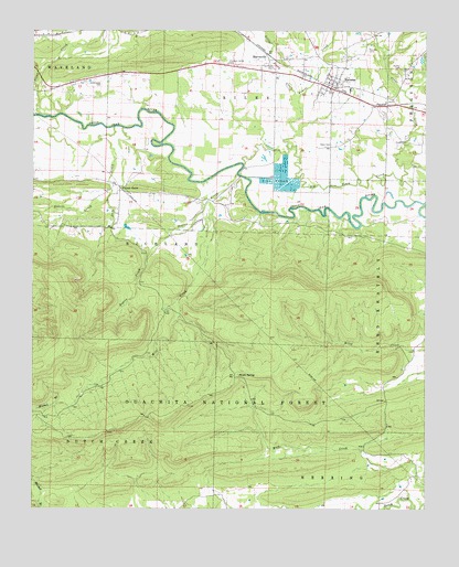
Havana, AR USGS Topographic Map
Click on map above to begin viewing in our Map Viewer.

This topographic map contains these locations and features:
Feature Name Type Latitude Longitude GNIS ID View Map
Big Piney CreekStreamN35.0806°W93.5032°70675View Map
Cedar CreekStreamN35.0862°W93.5077°71078View Map
City of HavanaCivilN35.1098°W93.5261°2404662View Map
Clear CreekStreamN35.1029°W93.6230°71164View Map
Davis Family CemeteryCemeteryN35.0954°W93.5302°71341View Map
Dentontown (historical)Populated PlaceN35.0084°W93.5052°67886View Map
East Cedar CreekStreamN35.1093°W93.5069°71494View Map
Guinn CemeteryCemeteryN35.0962°W93.5057°71849View Map
HavanaPopulated PlaceN35.1112°W93.5296°71938View Map
Havana Post OfficePost OfficeN35.1110°W93.5338°85019View Map
Havana Volunteer Fire DepartmentBuildingN35.1104°W93.5278°2116548View Map
Jack CreekStreamN35.0998°W93.5994°72157View Map
Jones Lake Dam Number OneDamN35.0951°W93.5602°80516View Map
Little Piney CreekStreamN35.0951°W93.5441°72414View Map
Maple SpringSpringN35.0352°W93.5595°72549View Map
MarvinvillePopulated PlaceN35.1181°W93.5502°72564View Map
Marvinville School (historical)SchoolN35.1176°W93.5513°67910View Map
Mill CreekStreamN35.0804°W93.5688°72653View Map
Moss Creek School (historical)SchoolN35.0148°W93.5069°67914View Map
Owens LakeReservoirN35.0951°W93.5602°80517View Map
Piney Fork CemeteryCemeteryN35.1201°W93.5185°71939View Map
Pleasant Valley CemeteryCemeteryN35.1165°W93.5627°73137View Map
Rogers CreekStreamN35.0876°W93.5596°73370View Map
Township of RileyCivilN35.1229°W93.5496°69889View Map
Truett CreekStreamN35.1040°W93.5396°78588View Map
Underwood CemeteryCemeteryN35.1118°W93.6035°73934View Map
Walker CemeteryCemeteryN35.1159°W93.5082°73985View Map
Walnut GrovePopulated PlaceN35.0840°W93.5974°78679View Map
Walnut Grove School (historical)SchoolN35.0809°W93.5705°67962View Map
Western Yell County High SchoolSchoolN35.1091°W93.5243°67965View Map

Note: Coordinates in the location and feature list above are referenced to NAD83 datum.


Copyright (C) 2008-2025 Ryan Niemi / Sunset Dynamics ... All Rights Reserved