TopoQuest Logo
Do you find TopoQuest useful?
Help keep TopoQuest running and adding new maps/features by donating!
Bitcoin:  19c7KJd3qBynnjoSw5npx9KScwjBe4ifkT
Litecoin:  LXs6TkuXGGXo1vDsWCkWVdjQX94eUKd6ui
Home View Maps Find Maps Find Places Resources & Links


Bluffton, Arkansas Topographic Map

USGS Map Title: Bluffton, AR
USGS Map MRC: 34093H5
DRG (GeoTIFF) Download: o34093h5.tif


Neighboring USGS Topographic Map Quads:


  Blue Mountain Dam, AR  
35093A6
 

  Havana, AR  
35093A5
 

  Danville, AR  
35093A4
 

  Gravelly, AR  
34093H6
 

  Bluffton, AR  
34093H5
 

  Rover, AR  
34093H4
 

  Little Texas, AR  
34093G6
 

  Chula Mountain, AR  
34093G5
 

  Onyx, AR  
34093G4


Map MRC Location:

N35°
W94°
N35°
W93°
H8 H7 H6 H5 H4 H3 H2 H1
G8 G7 G6 G5 G4 G3 G2 G1
F8 F7 F6 F5 F4 F3 F2 F1
E8 E7 E6 E5 E4 E3 E2 E1
D8 D7 D6 D5 D4 D3 D2 D1
C8 C7 C6 C5 C4 C3 C2 C1
B8 B7 B6 B5 B4 B3 B2 B1
A8 A7 A6 A5 A4 A3 A2 A1
N34°
W94°
N34°
W93°

Bluffton, AR USGS 1:24K Topographic Map Preview:
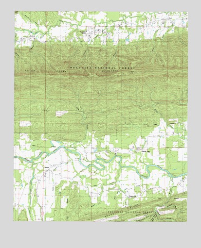
Bluffton, AR USGS Topographic Map
Click on map above to begin viewing in our Map Viewer.

This topographic map contains these locations and features:
Feature Name Type Latitude Longitude GNIS ID View Map
Bear CreekStreamN34.9018°W93.5099°70549View Map
BlufftonPopulated PlaceN34.9054°W93.6007°70742View Map
Bluffton CemeteryCemeteryN34.8979°W93.6066°2027366View Map
Bluffton Post OfficePost OfficeN34.9045°W93.6008°84401View Map
Briggs FordCrossingN34.9062°W93.5369°67862View Map
Briggs Memorial ParkCemeteryN34.9226°W93.5296°70822View Map
Cedar CreekStreamN34.9165°W93.5796°71060View Map
Chalybeate SpringsPopulated PlaceN34.9868°W93.5724°71108View Map
Chalybeate Springs CemeteryCemeteryN34.9884°W93.5696°2027402View Map
Chalybeate Springs School (historical)SchoolN34.9879°W93.5644°67868View Map
Fourche ValleyPopulated PlaceN34.9181°W93.5363°67890View Map
Fourche Valley Elementary SchoolSchoolN34.9188°W93.5355°2039176View Map
Fourche Valley High SchoolSchoolN34.9189°W93.5350°2039177View Map
Fourche Valley SchoolSchoolN34.9190°W93.5352°71669View Map
Gafford CreekStreamN34.9084°W93.6085°71709View Map
Gault BranchStreamN34.9076°W93.5480°71740View Map
Gault FordCrossingN34.9118°W93.5777°67892View Map
Henry BranchStreamN34.9990°W93.5163°71966View Map
Hopper CreekStreamN34.9084°W93.5002°81870View Map
Kitchen BranchStreamN34.9937°W93.5582°72268View Map
Left Prong Bear CreekStreamN34.8815°W93.5232°72305View Map
Lick BranchStreamN34.9023°W93.5341°72328View Map
McClain BranchStreamN34.9251°W93.5019°77625View Map
McKim BranchStreamN34.8965°W93.5613°72603View Map
Mitchell BranchStreamN34.9879°W93.6080°77677View Map
Mitchell BranchStreamN34.9951°W93.5469°72698View Map
Mount Pleasant CemeteryCemeteryN34.9831°W93.6199°2033637View Map
Nebo School (historical)SchoolN34.9931°W93.6071°67924View Map
Norris HollowValleyN34.8834°W93.5238°72880View Map
Omaha School (historical)SchoolN34.9165°W93.5382°67931View Map
Pea RidgeRidgeN34.8868°W93.5877°67934View Map
Pleasant HillPopulated PlaceN34.8893°W93.5380°73124View Map
Pleasant Hill School (historical)SchoolN34.8893°W93.5377°67938View Map
Poda BranchStreamN34.8937°W93.5460°73143View Map
Right Prong Bear CreekStreamN34.8815°W93.5230°73295View Map
SharkPopulated PlaceN34.9951°W93.5149°78332View Map
Straight Rock CreekStreamN34.8848°W93.5163°73734View Map
Swaim BranchStreamN34.9070°W93.5730°73792View Map
Township of BlufftonCivilN34.8976°W93.5986°69868View Map
Township of BriggsvilleCivilN34.9061°W93.5194°69869View Map
Township of HerringCivilN34.9852°W93.5208°69880View Map
WaltreakPopulated PlaceN34.9840°W93.6124°78687View Map
Waltreak CemeteryCemeteryN34.9831°W93.6199°2033680View Map
Waltreak Methodist ChurchChurchN34.9829°W93.6205°2033682View Map
Watson BranchStreamN34.9876°W93.6071°74020View Map
West Fourche Volunteer Fire DepartmentBuildingN34.9092°W93.5937°2117295View Map
Wildcat CreekStreamN34.9026°W93.5199°74382View Map
Wildcat CreekStreamN34.9018°W93.5110°67967View Map
Wildcat HollowValleyN34.8895°W93.5141°78773View Map

Note: Coordinates in the location and feature list above are referenced to NAD83 datum.


Copyright (C) 2008-2025 Ryan Niemi / Sunset Dynamics ... All Rights Reserved