TopoQuest Logo
Do you find TopoQuest useful?
Help keep TopoQuest running and adding new maps/features by donating!
Bitcoin:  19c7KJd3qBynnjoSw5npx9KScwjBe4ifkT
Litecoin:  LXs6TkuXGGXo1vDsWCkWVdjQX94eUKd6ui
Home View Maps Find Maps Find Places Resources & Links


Westlake, Georgia Topographic Map

USGS Map Title: Westlake, GA
USGS Map MRC: 32083D4
DRG (GeoTIFF) Download: o32083d4.tif


Neighboring USGS Topographic Map Quads:


  Warner Robins SE, GA  
32083E5
 

  Tarversville, GA  
32083E4
 

  Danville West, GA  
32083E3
 

  Hayneville, GA  
32083D5
 

  Westlake, GA  
32083D4
 

  Cochran, GA  
32083D3
 

  Klondike, GA  
32083C5
 

  Hawkinsville, GA  
32083C4
 

  Empire, GA  
32083C3


Map MRC Location:

N33°
W84°
N33°
W83°
H8 H7 H6 H5 H4 H3 H2 H1
G8 G7 G6 G5 G4 G3 G2 G1
F8 F7 F6 F5 F4 F3 F2 F1
E8 E7 E6 E5 E4 E3 E2 E1
D8 D7 D6 D5 D4 D3 D2 D1
C8 C7 C6 C5 C4 C3 C2 C1
B8 B7 B6 B5 B4 B3 B2 B1
A8 A7 A6 A5 A4 A3 A2 A1
N32°
W84°
N32°
W83°

Westlake, GA USGS 1:24K Topographic Map Preview:
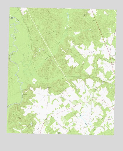
Westlake, GA USGS Topographic Map
Click on map above to begin viewing in our Map Viewer.

This topographic map contains these locations and features:
Feature Name Type Latitude Longitude GNIS ID View Map
Ainslie (historical)Populated PlaceN32.4485°W83.4716°334609View Map
Antioch ChurchChurchN32.4210°W83.4530°310572View Map
Big Grocery CreekStreamN32.4546°W83.4971°311385View Map
Bleckley SchoolSchoolN32.3904°W83.3791°354769View Map
Bollinger CreekStreamN32.4513°W83.3802°311631View Map
Cedar Hill School (historical)SchoolN32.4152°W83.4388°334613View Map
Centenary Methodist Church (historical)ChurchN32.4132°W83.4527°342369View Map
Cochran - Bleckley Fire Department Porter Road StationBuildingN32.4111°W83.3999°2604846View Map
ColeyPopulated PlaceN32.4282°W83.3888°326225View Map
Coley CreekStreamN32.4277°W83.3888°312834View Map
Crooked CreekStreamN32.4910°W83.4963°313141View Map
Evergreen ChurchChurchN32.4532°W83.3793°355742View Map
Evergreen CreekStreamN32.4332°W83.4049°314015View Map
James Dykes Memorial ParkCemeteryN32.4143°W83.4821°316040View Map
Little Grocery CreekStreamN32.4618°W83.4943°317076View Map
MagnoliaLocaleN32.4302°W83.4538°326384View Map
McGriff (historical)Populated PlaceN32.4329°W83.4157°334616View Map
PaulkPopulated PlaceN32.3860°W83.4052°326457View Map
Paulk LakesLakeN32.3899°W83.4116°320290View Map
Pine Grove ChurchChurchN32.4207°W83.3985°320569View Map
PorterPopulated PlaceN32.4129°W83.3996°326476View Map
RoyalPopulated PlaceN32.4457°W83.3788°326502View Map
Shellstone CreekStreamN32.4335°W83.4727°322832View Map
South Shellstone CreekStreamN32.4335°W83.4727°356547View Map
Stephens BluffCliffN32.4163°W83.4816°350747View Map
Trunell PondReservoirN32.3938°W83.4117°341065View Map
Trunell Pond DamDamN32.3935°W83.4116°341064View Map
Walker CemeteryCemeteryN32.4885°W83.3996°324768View Map
WestlakePopulated PlaceN32.4890°W83.4835°356631View Map
Wimberly School (historical)SchoolN32.3824°W83.4079°334621View Map

Note: Coordinates in the location and feature list above are referenced to NAD83 datum.


Copyright (C) 2008-2025 Ryan Niemi / Sunset Dynamics ... All Rights Reserved