TopoQuest Logo
Do you find TopoQuest useful?
Help keep TopoQuest running and adding new maps/features by donating!
Bitcoin:  19c7KJd3qBynnjoSw5npx9KScwjBe4ifkT
Litecoin:  LXs6TkuXGGXo1vDsWCkWVdjQX94eUKd6ui
Home View Maps Find Maps Find Places Resources & Links


Joyland, Arkansas Topographic Map

USGS Map Title: Joyland, AR
USGS Map MRC: 35090D4
DRG (GeoTIFF) Download: o35090d4.tif


Neighboring USGS Topographic Map Quads:


  McCormick, AR  
35090E5
 

  Marked Tree, AR  
35090E4
 

  Lepanto, AR  
35090E3
 

  Monterey, AR  
35090D5
 

  Joyland, AR  
35090D4
 

  Tyronza, AR  
35090D3
 

  Parkin, AR  
35090C5
 

  Earle, AR  
35090C4
 

  Heafer, AR  
35090C3


Map MRC Location:

N36°
W91°
N36°
W90°
H8 H7 H6 H5 H4 H3 H2 H1
G8 G7 G6 G5 G4 G3 G2 G1
F8 F7 F6 F5 F4 F3 F2 F1
E8 E7 E6 E5 E4 E3 E2 E1
D8 D7 D6 D5 D4 D3 D2 D1
C8 C7 C6 C5 C4 C3 C2 C1
B8 B7 B6 B5 B4 B3 B2 B1
A8 A7 A6 A5 A4 A3 A2 A1
N35°
W91°
N35°
W90°

Joyland, AR USGS 1:24K Topographic Map Preview:
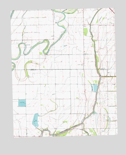
Joyland, AR USGS Topographic Map
Click on map above to begin viewing in our Map Viewer.

This topographic map contains these locations and features:
Feature Name Type Latitude Longitude GNIS ID View Map
Black OakPopulated PlaceN35.4551°W90.4132°46674View Map
Black Oak Baptist ChurchChurchN35.4554°W90.4137°65763View Map
Black Oak School (historical)SchoolN35.3965°W90.4134°59224View Map
Black Oak School (historical)SchoolN35.4551°W90.4134°82798View Map
Broad Mouth Lake (historical)LakeN35.4312°W90.4879°82792View Map
Cow IslandBendN35.4456°W90.4984°48118View Map
Cummins BarBarN35.4659°W90.4826°48262View Map
Ditch Number 14CanalN35.4179°W90.3759°82086View Map
Ditch Number 15CanalN35.4031°W90.3762°82093View Map
Ditch Number 18CanalN35.3887°W90.3759°82120View Map
Ditch Number 43CanalN35.4923°W90.4718°82266View Map
Ditch Number 44CanalN35.4776°W90.4759°82268View Map
East Tyronza CemeteryCemeteryN35.4842°W90.3804°82809View Map
GalileePopulated PlaceN35.4362°W90.3851°57787View Map
Galilee Church (historical)ChurchN35.4387°W90.3854°82793View Map
Galilee School (historical)SchoolN35.4387°W90.3854°82794View Map
JoylandPopulated PlaceN35.4742°W90.4490°58001View Map
King Solomon CemeteryCemeteryN35.3820°W90.4165°50860View Map
King Solomon Church (historical)ChurchN35.3820°W90.4168°59225View Map
King Solomon School (historical)SchoolN35.3823°W90.4173°82795View Map
Kingdom HallChurchN35.3898°W90.3857°67788View Map
Liberty ChurchChurchN35.3954°W90.4132°51104View Map
Lost Trap LakeLakeN35.4640°W90.4373°75002View Map
Luss LakeReservoirN35.4219°W90.4043°75012View Map
Mack BayouStreamN35.3798°W90.4654°51587View Map
Macks BaoyLocaleN35.3959°W90.4665°78880View Map
Mount OlivePopulated PlaceN35.4826°W90.4129°57130View Map
Mount Olive CemeteryCemeteryN35.4831°W90.4120°59287View Map
Mount Olive ChurchChurchN35.4837°W90.4120°59286View Map
New Hope ChurchChurchN35.4248°W90.3765°52691View Map
Saint Church (historical)ChurchN35.4551°W90.3848°59288View Map
Saint Pauls Church (historical)ChurchN35.3762°W90.4993°82796View Map
Sand SloughStreamN35.4679°W90.4873°54545View Map
Township of Black OakCivilN35.3890°W90.4217°68745View Map
Tyronza River CutoffBendN35.3806°W90.4362°55776View Map
Wooden Chapel (historical)ChurchN35.4104°W90.4112°82797View Map
Yellow BanksPopulated PlaceN35.4870°W90.4440°58925View Map

Note: Coordinates in the location and feature list above are referenced to NAD83 datum.


Copyright (C) 2008-2024 Ryan Niemi / Sunset Dynamics ... All Rights Reserved