TopoQuest Logo
Do you find TopoQuest useful?
Help keep TopoQuest running and adding new maps/features by donating!
Bitcoin:  19c7KJd3qBynnjoSw5npx9KScwjBe4ifkT
Litecoin:  LXs6TkuXGGXo1vDsWCkWVdjQX94eUKd6ui
Home View Maps Find Maps Find Places Resources & Links


Earle, Arkansas Topographic Map

USGS Map Title: Earle, AR
USGS Map MRC: 35090C4
DRG (GeoTIFF) Download: o35090c4.tif


Neighboring USGS Topographic Map Quads:


  Monterey, AR  
35090D5
 

  Joyland, AR  
35090D4
 

  Tyronza, AR  
35090D3
 

  Parkin, AR  
35090C5
 

  Earle, AR  
35090C4
 

  Heafer, AR  
35090C3
 

  Gieseck, AR  
35090B5
 

  Jeanette, AR  
35090B4
 

  Crawfordsville, AR  
35090B3


Map MRC Location:

N36°
W91°
N36°
W90°
H8 H7 H6 H5 H4 H3 H2 H1
G8 G7 G6 G5 G4 G3 G2 G1
F8 F7 F6 F5 F4 F3 F2 F1
E8 E7 E6 E5 E4 E3 E2 E1
D8 D7 D6 D5 D4 D3 D2 D1
C8 C7 C6 C5 C4 C3 C2 C1
B8 B7 B6 B5 B4 B3 B2 B1
A8 A7 A6 A5 A4 A3 A2 A1
N35°
W91°
N35°
W90°

Earle, AR USGS 1:24K Topographic Map Preview:
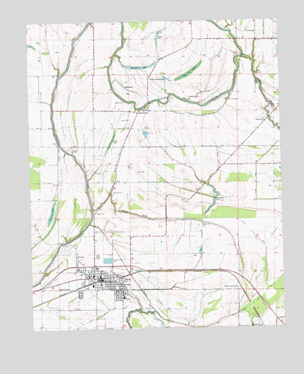
Earle, AR USGS Topographic Map
Click on map above to begin viewing in our Map Viewer.

This topographic map contains these locations and features:
Feature Name Type Latitude Longitude GNIS ID View Map
Barton ChapelChurchN35.3704°W90.3868°46127View Map
Beautiful LakeLakeN35.3566°W90.4446°74646View Map
Berry CemeteryCemeteryN35.2973°W90.4670°46407View Map
Big CreekStreamN35.3604°W90.3937°46532View Map
Big LakeLakeN35.3540°W90.4198°74669View Map
Black Oak Church (historical)ChurchN35.3381°W90.4270°59231View Map
Brougham LakeLakeN35.3029°W90.4079°74700View Map
Cane LakeLakeN35.2975°W90.4895°76519View Map
City of EarleCivilN35.2734°W90.4643°2403528View Map
CloarPopulated PlaceN35.3098°W90.4579°56963View Map
Cloar CemeteryCemeteryN35.3138°W90.4429°47860View Map
Ditch Number 1CanalN35.3187°W90.4065°82017View Map
Ditch Number 1CanalN35.2601°W90.3890°82029View Map
Ditch Number 13CanalN35.2831°W90.3840°82068View Map
Ditch Number 22CanalN35.3715°W90.3818°82163View Map
Ditch Number 9CanalN35.3018°W90.3848°82417View Map
Dunbar Elementary SchoolSchoolN35.2715°W90.4709°2039150View Map
Dunbar High SchoolSchoolN35.2626°W90.4545°48699View Map
Dunbar Middle SchoolSchoolN35.2713°W90.4714°2093348View Map
EarlePopulated PlaceN35.2751°W90.4668°48738View Map
Earle Elementary SchoolSchoolN35.2720°W90.4693°67758View Map
Earle Emergency AmbulanceBuildingN35.2708°W90.4667°2119115View Map
Earle Fire StationBuildingN35.2708°W90.4667°2116377View Map
Earle High SchoolSchoolN35.2769°W90.4488°67759View Map
Earle Middle SchoolSchoolN35.2712°W90.4715°67760View Map
Earle Police DepartmentBuildingN35.2707°W90.4642°2118564View Map
Gibson BayouStreamN35.2979°W90.4693°49390View Map
Gibson Bayou CemeteryCemeteryN35.3054°W90.4593°59229View Map
Gibson Bayou ChurchChurchN35.3056°W90.4595°49391View Map
Grassy Lake BottomPopulated PlaceN35.2681°W90.3959°49579View Map
Hood CemeteryCemeteryN35.3421°W90.4530°50286View Map
Hood LakeLakeN35.3481°W90.4515°74903View Map
LansingPopulated PlaceN35.2504°W90.3868°58046View Map
Layton CemeteryCemeteryN35.3349°W90.4500°51016View Map
Lewis LakeLakeN35.3265°W90.4587°74945View Map
Little Grassy LakeLakeN35.3517°W90.4310°74959View Map
New Prosperity ChurchChurchN35.3429°W90.4007°77839View Map
NorvellPopulated PlaceN35.2795°W90.4776°52848View Map
Pilgrims Rest ChurchChurchN35.3340°W90.3829°53389View Map
PoindexterPopulated PlaceN35.3676°W90.4176°59230View Map
Prosperity CemeteryCemeteryN35.3428°W90.4007°59234View Map
Prosperity School (historical)SchoolN35.3423°W90.4012°59233View Map
Richard CemeteryCemeteryN35.3385°W90.4432°54010View Map
Russell CemeteryCemeteryN35.2576°W90.4426°54285View Map
Saint Peter School (historical)SchoolN35.2895°W90.4684°59228View Map
Saint Peters ChurchChurchN35.3318°W90.4520°54469View Map
ShannonvillePopulated PlaceN35.2665°W90.4815°58603View Map
Spring Hill CemeteryCemeteryN35.2926°W90.4143°55108View Map
Spring Hill Church (historical)ChurchN35.2926°W90.4145°59232View Map
Stump LakeLakeN35.3703°W90.4341°75150View Map
Three ForksPopulated PlaceN35.3379°W90.4457°58744View Map
Tupelo BrakeCanalN35.2656°W90.4457°55701View Map

Note: Coordinates in the location and feature list above are referenced to NAD83 datum.


Copyright (C) 2008-2024 Ryan Niemi / Sunset Dynamics ... All Rights Reserved