TopoQuest Logo
Do you find TopoQuest useful?
Help keep TopoQuest running and adding new maps/features by donating!
Bitcoin:  19c7KJd3qBynnjoSw5npx9KScwjBe4ifkT
Litecoin:  LXs6TkuXGGXo1vDsWCkWVdjQX94eUKd6ui
Home View Maps Find Maps Find Places Resources & Links


Italia, Florida Topographic Map

USGS Map Title: Italia, FL
USGS Map MRC: 30081E6
DRG (GeoTIFF) Download: o30081e6.tif


Neighboring USGS Topographic Map Quads:


  Hilliard NE, FL  
30081F7
 

  Gross, FL  
30081F6
 

  Saint Marys, GA  
30081F5
 

  Callahan, FL  
30081E7
 

  Italia, FL  
30081E6
 

  Hedges, FL  
30081E5
 

  Dinsmore, FL  
30081D7
 

  Trout River, FL  
30081D6
 

  Eastport, FL  
30081D5


Map MRC Location:

N31°
W82°
N31°
W81°
H8 H7 H6 H5 H4 H3 H2 H1
G8 G7 G6 G5 G4 G3 G2 G1
F8 F7 F6 F5 F4 F3 F2 F1
E8 E7 E6 E5 E4 E3 E2 E1
D8 D7 D6 D5 D4 D3 D2 D1
C8 C7 C6 C5 C4 C3 C2 C1
B8 B7 B6 B5 B4 B3 B2 B1
A8 A7 A6 A5 A4 A3 A2 A1
N30°
W82°
N30°
W81°

Italia, FL USGS 1:24K Topographic Map Preview:
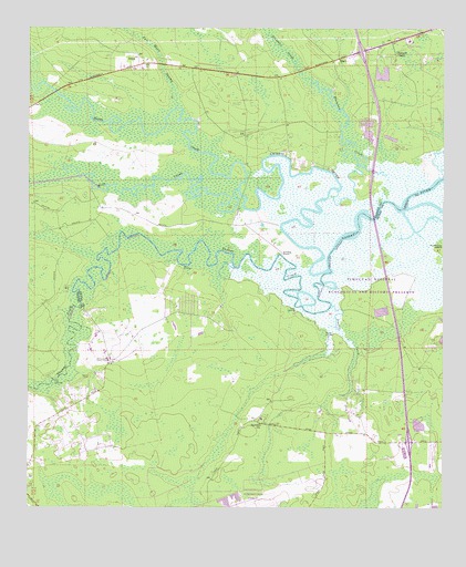
Italia, FL USGS Topographic Map
Click on map above to begin viewing in our Map Viewer.

This topographic map contains these locations and features:
Feature Name Type Latitude Longitude GNIS ID View Map
Alligator CreekChannelN30.5833°W81.6868°277779View Map
Baine Airport (historical)AirportN30.5266°W81.6404°309740View Map
Barford ChurchChurchN30.5216°W81.6793°278108View Map
Clay LandingLocaleN30.5338°W81.7426°295200View Map
Harpers ChapelChurchN30.6186°W81.6393°283754View Map
HeroPopulated PlaceN30.6172°W81.6559°295346View Map
Interchange 366CrossingN30.5176°W81.6351°2476698View Map
Interchange 373CrossingN30.6194°W81.6499°2476699View Map
ItaliaPopulated PlaceN30.6166°W81.7170°294814View Map
Jacksonville Fire and Rescue Department Station 47BuildingN30.5386°W81.7250°2476003View Map
Jacksonville National CemeteryCemeteryN30.5447°W81.7195°2701876View Map
Jacksonville Penal FarmLocaleN30.5386°W81.7254°284703View Map
Joels LandingPopulated PlaceN30.5519°W81.6687°294818View Map
Lannie Road Baptist ChurchChurchN30.5212°W81.7469°2476380View Map
Mary Smith GrantCivilN30.5600°W81.6979°303991View Map
Mills CreekStreamN30.5833°W81.6868°277648View Map
Montgomery Correctional CenterBuildingN30.5409°W81.7266°2753103View Map
Nassau County Detention CenterBuildingN30.6223°W81.6354°2476030View Map
Nassau County JailBuildingN30.6110°W81.6311°2753094View Map
Nassau County Sheriff's OfficeBuildingN30.6224°W81.6352°2333126View Map
Ogilvie CemeteryCemeteryN30.5341°W81.7309°288061View Map
Plummer CreekStreamN30.5819°W81.6565°289090View Map
Seaton CreekStreamN30.5527°W81.6584°290802View Map
Seaton LandingLocaleN30.5455°W81.6604°295606View Map
Smiths PointCapeN30.5663°W81.6701°291260View Map
Thomas CreekStreamN30.5611°W81.6609°292201View Map
West LandingLocaleN30.5625°W81.7034°295704View Map
William Gibson and Others GrantCivilN30.5391°W81.7187°303992View Map
William Gibson and Others GrantCivilN30.5244°W81.7462°303993View Map

Note: Coordinates in the location and feature list above are referenced to NAD83 datum.


Copyright (C) 2008-2025 Ryan Niemi / Sunset Dynamics ... All Rights Reserved