TopoQuest Logo
Do you find TopoQuest useful?
Help keep TopoQuest running and adding new maps/features by donating!
Bitcoin:  19c7KJd3qBynnjoSw5npx9KScwjBe4ifkT
Litecoin:  LXs6TkuXGGXo1vDsWCkWVdjQX94eUKd6ui
Home View Maps Find Maps Find Places Resources & Links


Dividing Creek, New Jersey Topographic Map

USGS Map Title: Dividing Creek, NJ
USGS Map MRC: 39075C1
DRG (GeoTIFF) Download: o39075c1.tif


Neighboring USGS Topographic Map Quads:


  Bridgeton, NJ  
39075D2
 

  Millville, NJ  
39075D1
 

  Five Points, NJ  
39074D8
 

  Cedarville, NJ  
39075C2
 

  Dividing Creek, NJ  
39075C1
 

  Port Elizabeth, NJ  
39074C8
 

  Fortescue, NJ  
39075B2
 

  Port Norris, NJ  
39075B1
 

  Heislerville, NJ  
39074B8


Map MRC Location:

N40°
W76°
N40°
W75°
H8 H7 H6 H5 H4 H3 H2 H1
G8 G7 G6 G5 G4 G3 G2 G1
F8 F7 F6 F5 F4 F3 F2 F1
E8 E7 E6 E5 E4 E3 E2 E1
D8 D7 D6 D5 D4 D3 D2 D1
C8 C7 C6 C5 C4 C3 C2 C1
B8 B7 B6 B5 B4 B3 B2 B1
A8 A7 A6 A5 A4 A3 A2 A1
N39°
W76°
N39°
W75°

Dividing Creek, NJ USGS 1:24K Topographic Map Preview:
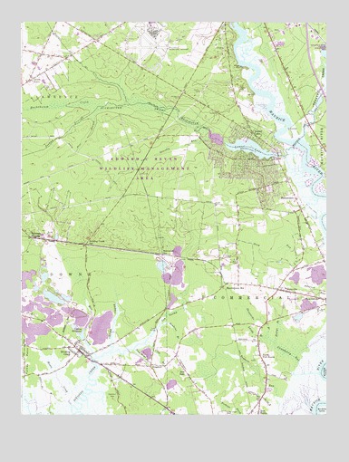
Dividing Creek, NJ USGS Topographic Map
Click on map above to begin viewing in our Map Viewer.

This topographic map contains these locations and features:
Feature Name Type Latitude Longitude GNIS ID View Map
BaileytownPopulated PlaceN39.3196°W75.0730°882941View Map
Beaver DamDamN39.3368°W75.0427°883934View Map
Beaver LakeReservoirN39.3381°W75.0453°883933View Map
BuckshutemPopulated PlaceN39.3190°W75.0127°875011View Map
Buckshutem CreekStreamN39.3352°W75.0146°875012View Map
Buckshutem SwampSwampN39.3482°W75.0796°875013View Map
Cedar CreekStreamN39.2704°W75.0882°875267View Map
Centre GrovePopulated PlaceN39.3565°W75.1218°875356View Map
Clarks MillPopulated PlaceN39.3598°W75.0171°883094View Map
Clay BranchStreamN39.2729°W75.0743°875471View Map
Cranberry GutGutN39.2687°W75.0141°875698View Map
Creative Achievement Academy Downe AcademySchoolN39.2716°W75.1022°2333450View Map
Cub SwampSwampN39.2809°W75.0652°875769View Map
Dividing CreekPopulated PlaceN39.2704°W75.1010°875926View Map
Dividing Creek Fire CompanyBuildingN39.2736°W75.1009°2401889View Map
Dividing Creek Post OfficePost OfficeN39.2713°W75.1010°2781425View Map
Dividing Creek StationLocaleN39.3043°W75.0985°875928View Map
DragstonPopulated PlaceN39.2657°W75.0721°875966View Map
Edward G Bevan Fish and Wildlife Management AreaParkN39.3251°W75.0746°883030View Map
Gravelly RunStreamN39.3380°W75.0480°876729View Map
Haleys BranchStreamN39.2729°W75.0212°876886View Map
HaleyvillePopulated PlaceN39.2896°W75.0168°876887View Map
Haleyville Mauricetown Elementary SchoolSchoolN39.2825°W75.0236°2333437View Map
Iron Mine BranchStreamN39.2709°W75.0784°877356View Map
Joshua BranchStreamN39.3482°W75.0935°877493View Map
Ladow MillpondReservoirN39.2795°W75.0971°877620View Map
Lands BranchStreamN39.2744°W75.0255°877665View Map
Laurel LakePopulated PlaceN39.3396°W75.0299°877684View Map
Laurel LakeLakeN39.3347°W75.0310°883093View Map
Laurel LakeReservoirN39.3326°W75.0196°883935View Map
Laurel Lake Census Designated PlaceCensusN39.3265°W75.0305°2390038View Map
Laurel Lake DamDamN39.3326°W75.0196°883936View Map
Laurel Lake Volunteer Fire CompanyBuildingN39.3320°W75.0383°2401901View Map
Laurel Lakes Volunteer Rescue SquadBuildingN39.3220°W75.0277°2660100View Map
Lores MillPopulated PlaceN39.2840°W75.0655°883092View Map
Maple CreekStreamN39.2591°W75.0987°878090View Map
Mauricetown StationLocaleN39.2904°W75.0427°878201View Map
Menantico CreekStreamN39.3380°W75.0107°878062View Map
Menantico Ponds Fish and Wildlife Management AreaParkN39.3723°W75.0038°883031View Map
Mill CreekStreamN39.2683°W75.0941°878349View Map
Millville Army Air Field (historical)MilitaryN39.3678°W75.0731°2092798View Map
Millville Municipal AirportAirportN39.3678°W75.0722°884829View Map
New ItalyPopulated PlaceN39.2637°W75.0571°878740View Map
New Jersey State Police Troop A Port Norris StationBuildingN39.2881°W75.0125°2731046View Map
North Port NorrisPopulated PlaceN39.2687°W75.0268°878866View Map
Owls Nest FieldParkN39.2551°W75.0880°879063View Map
Paynters CrossingPopulated PlaceN39.3065°W75.1216°879179View Map
Pine BranchStreamN39.3482°W75.0935°879290View Map
Port Norris Census Designated PlaceCensusN39.2501°W75.0414°2389697View Map
Reubens BranchStreamN39.2785°W75.0682°879667View Map
Sheppards BranchStreamN39.2746°W75.0252°880547View Map
Steep RunStreamN39.3070°W75.0002°880873View Map
Toms BridgeBridgeN39.2771°W75.0693°881206View Map
Township of CommercialCivilN39.2746°W75.0414°882062View Map
Whitehead StationLocaleN39.3009°W75.0674°881796View Map

Note: Coordinates in the location and feature list above are referenced to NAD83 datum.


Copyright (C) 2008-2025 Ryan Niemi / Sunset Dynamics ... All Rights Reserved