TopoQuest Logo
Do you find TopoQuest useful?
Help keep TopoQuest running and adding new maps/features by donating!
Bitcoin:  19c7KJd3qBynnjoSw5npx9KScwjBe4ifkT
Litecoin:  LXs6TkuXGGXo1vDsWCkWVdjQX94eUKd6ui
Home View Maps Find Maps Find Places Resources & Links


Henry, Illinois Topographic Map

USGS Map Title: Henry, IL
USGS Map MRC: 41089A3
DRG (GeoTIFF) Download: o41089a3.tif


Neighboring USGS Topographic Map Quads:


  Putnam, IL  
41089B4
 

  Florid, IL  
41089B3
 

  McNabb, IL  
41089B2
 

  Lacon, IL  
41089A4
 

  Henry, IL  
41089A3
 

  Varna, IL  
41089A2
 

  Chillicothe, IL  
40089H4
 

  Washburn, IL  
40089H3
 

  La Rose, IL  
40089H2


Map MRC Location:

N42°
W90°
N42°
W89°
H8 H7 H6 H5 H4 H3 H2 H1
G8 G7 G6 G5 G4 G3 G2 G1
F8 F7 F6 F5 F4 F3 F2 F1
E8 E7 E6 E5 E4 E3 E2 E1
D8 D7 D6 D5 D4 D3 D2 D1
C8 C7 C6 C5 C4 C3 C2 C1
B8 B7 B6 B5 B4 B3 B2 B1
A8 A7 A6 A5 A4 A3 A2 A1
N41°
W90°
N41°
W89°

Henry, IL USGS 1:24K Topographic Map Preview:
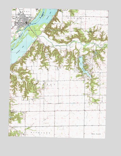
Henry, IL USGS Topographic Map
Click on map above to begin viewing in our Map Viewer.

This topographic map contains these locations and features:
Feature Name Type Latitude Longitude GNIS ID View Map
Barnes LakeReservoirN41.0185°W89.3730°1692531View Map
Barnes Lake DamDamN41.0184°W89.3734°1692530View Map
Billsbach LakeLakeN41.0816°W89.3663°404449View Map
Caledonia (historical)Populated PlaceN41.1184°W89.2504°1820608View Map
City of HenryCivilN41.1174°W89.3567°2394355View Map
Forbes CemeteryCemeteryN41.0659°W89.3262°408492View Map
George S Park Memorial Woods Nature PreserveParkN41.1214°W89.2968°1820611View Map
Greeves CemeteryCemeteryN41.0239°W89.3734°409478View Map
Harmony School (historical)SchoolN41.0642°W89.2543°1719768View Map
Harris CemeteryCemeteryN41.0369°W89.3441°409845View Map
HeldLocaleN41.0325°W89.3162°1719770View Map
HenryPopulated PlaceN41.1114°W89.3565°410067View Map
Henry CemeteryCemeteryN41.1234°W89.3720°410068View Map
Henry Community Ambulance ServiceBuildingN41.1101°W89.3665°2673873View Map
Henry Fire Protection DistrictBuildingN41.1101°W89.3665°2640464View Map
Henry Police DepartmentBuildingN41.1107°W89.3659°2756893View Map
Henry Post OfficePost OfficeN41.1114°W89.3580°2788366View Map
Henry-Senachwine Grade SchoolSchoolN41.1167°W89.3515°1808661View Map
Henry-Senachwine High SchoolSchoolN41.1159°W89.3681°1719774View Map
Hopewell TownhallBuildingN41.0548°W89.3295°1719773View Map
Kings House of Retreats ChapelChurchN41.1236°W89.3143°411509View Map
Lacon Country ClubLocaleN41.0250°W89.3712°425088View Map
Lake TanglewoodReservoirN41.0827°W89.2634°1691529View Map
Lake Tanglewood DamDamN41.0841°W89.2655°1691528View Map
Lake WildwoodReservoirN41.0652°W89.2789°421165View Map
Marshall CountyCivilN41.0332°W89.3448°424260View Map
Marshall School (historical)SchoolN41.0245°W89.3687°1719772View Map
Newhaven LakeLakeN41.0928°W89.3743°414488View Map
Russell CemeteryCemeteryN41.0239°W89.3556°417064View Map
Sandy CreekStreamN41.1086°W89.3476°417995View Map
Sawmill LakeLakeN41.1210°W89.3261°418045View Map
Sawyer CemeteryCemeteryN41.0667°W89.3034°418046View Map
Sawyer School (historical)SchoolN41.0723°W89.3065°1719767View Map
Shaw CreekStreamN41.0911°W89.2834°418305View Map
Shaws Point School (historical)SchoolN41.0278°W89.2593°1719769View Map
Strawn CemeteryCemeteryN41.0024°W89.3569°419209View Map
Tax School (historical)SchoolN41.0259°W89.3165°1719771View Map
Township of HopewellCivilN41.0549°W89.3329°429149View Map
Whitney LakeLakeN41.1026°W89.3655°421111View Map
Wildwood Lake DamDamN41.0795°W89.2870°1691071View Map
WRVY-FM (Henry)TowerN41.0756°W89.3529°428499View Map

Note: Coordinates in the location and feature list above are referenced to NAD83 datum.


Copyright (C) 2008-2025 Ryan Niemi / Sunset Dynamics ... All Rights Reserved