TopoQuest Logo
Do you find TopoQuest useful?
Help keep TopoQuest running and adding new maps/features by donating!
Bitcoin:  19c7KJd3qBynnjoSw5npx9KScwjBe4ifkT
Litecoin:  LXs6TkuXGGXo1vDsWCkWVdjQX94eUKd6ui
Home View Maps Find Maps Find Places Resources & Links


Putnam, Illinois Topographic Map

USGS Map Title: Putnam, IL
USGS Map MRC: 41089B4
DRG (GeoTIFF) Download: o41089b4.tif


Neighboring USGS Topographic Map Quads:


  Wyanet, IL  
41089C5
 

  Princeton South, IL  
41089C4
 

  Depue, IL  
41089C3
 

  Whitefield, IL  
41089B5
 

  Putnam, IL  
41089B4
 

  Florid, IL  
41089B3
 

  La Prairie Center, IL  
41089A5
 

  Lacon, IL  
41089A4
 

  Henry, IL  
41089A3


Map MRC Location:

N42°
W90°
N42°
W89°
H8 H7 H6 H5 H4 H3 H2 H1
G8 G7 G6 G5 G4 G3 G2 G1
F8 F7 F6 F5 F4 F3 F2 F1
E8 E7 E6 E5 E4 E3 E2 E1
D8 D7 D6 D5 D4 D3 D2 D1
C8 C7 C6 C5 C4 C3 C2 C1
B8 B7 B6 B5 B4 B3 B2 B1
A8 A7 A6 A5 A4 A3 A2 A1
N41°
W90°
N41°
W89°

Putnam, IL USGS 1:24K Topographic Map Preview:
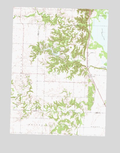
Putnam, IL USGS Topographic Map
Click on map above to begin viewing in our Map Viewer.

This topographic map contains these locations and features:
Feature Name Type Latitude Longitude GNIS ID View Map
Bachman School (historical)SchoolN41.2203°W89.4565°1719788View Map
Edgar Read AirportAirportN41.1843°W89.4418°427717View Map
Goose LakeLakeN41.2261°W89.3806°409179View Map
Henkins School (historical)SchoolN41.1770°W89.4326°1719791View Map
Henry Fire Protection District Station 3BuildingN41.1817°W89.3961°2640724View Map
Lake ThunderbirdReservoirN41.2069°W89.4470°419705View Map
Lake Thunderbird DamDamN41.2050°W89.4375°1691618View Map
Lone Tree CemeteryCemeteryN41.1842°W89.4820°412543View Map
Lone Tree CornersPopulated PlaceN41.1848°W89.4856°1719790View Map
Maupin LakeReservoirN41.1521°W89.4942°1692439View Map
Maupin Lake DamDamN41.1534°W89.4934°1692438View Map
Miller-Anderson Woods State Nature PreserveParkN41.2375°W89.4056°1822687View Map
Morris School (historical)SchoolN41.2489°W89.4987°1719787View Map
Nye School (historical)SchoolN41.2481°W89.4220°1719786View Map
PutnamPopulated PlaceN41.1850°W89.3965°416295View Map
Putnam CemeteryCemeteryN41.1853°W89.3901°1967960View Map
Putnam Post OfficePost OfficeN41.1819°W89.3960°1820616View Map
Putnman CemeteryCemeteryN41.1856°W89.3901°1953546View Map
Quinn School (historical)SchoolN41.1336°W89.4040°1719793View Map
Ralph E Daniels AirportAirportN41.2000°W89.3972°427716View Map
Saint Joseph CemeteryCemeteryN41.2028°W89.4376°417435View Map
Salem Church (historical)ChurchN41.2278°W89.4126°1719785View Map
Stauffer School (historical)SchoolN41.2217°W89.4862°1719789View Map
Steil RLA AirportAirportN41.2340°W89.4533°2770505View Map
Sugar Grove CemeteryCemeteryN41.1270°W89.4462°419303View Map
Sugar Grove School (historical)SchoolN41.1331°W89.4576°1719792View Map
Tiskilwa Fire Protection District Station 2BuildingN41.2137°W89.4575°2640462View Map
Township of SenachwineCivilN41.1886°W89.4005°429729View Map
Township of WheatlandCivilN41.1912°W89.4955°429924View Map

Note: Coordinates in the location and feature list above are referenced to NAD83 datum.


Copyright (C) 2008-2025 Ryan Niemi / Sunset Dynamics ... All Rights Reserved