TopoQuest Logo
Do you find TopoQuest useful?
Help keep TopoQuest running and adding new maps/features by donating!
Bitcoin:  19c7KJd3qBynnjoSw5npx9KScwjBe4ifkT
Litecoin:  LXs6TkuXGGXo1vDsWCkWVdjQX94eUKd6ui
Home View Maps Find Maps Find Places Resources & Links


Azalia, Indiana Topographic Map

USGS Map Title: Azalia, IN
USGS Map MRC: 39085A7
DRG (GeoTIFF) Download: o39085a7.tif


Neighboring USGS Topographic Map Quads:


  Columbus, IN  
39085B8
 

  Elizabethtown, IN  
39085B7
 

  Grammer, IN  
39085B6
 

  Jonesville, IN  
39085A8
 

  Azalia, IN  
39085A7
 

  North Vernon, IN  
39085A6
 

  Seymour, IN  
38085H8
 

  Chestnut Ridge, IN  
38085H7
 

  Hayden, IN  
38085H6


Map MRC Location:

N40°
W86°
N40°
W85°
H8 H7 H6 H5 H4 H3 H2 H1
G8 G7 G6 G5 G4 G3 G2 G1
F8 F7 F6 F5 F4 F3 F2 F1
E8 E7 E6 E5 E4 E3 E2 E1
D8 D7 D6 D5 D4 D3 D2 D1
C8 C7 C6 C5 C4 C3 C2 C1
B8 B7 B6 B5 B4 B3 B2 B1
A8 A7 A6 A5 A4 A3 A2 A1
N39°
W86°
N39°
W85°

Azalia, IN USGS 1:24K Topographic Map Preview:
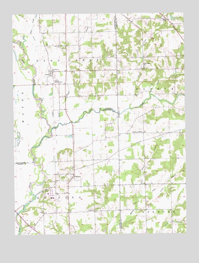
Azalia, IN USGS Topographic Map
Click on map above to begin viewing in our Map Viewer.

This topographic map contains these locations and features:
Feature Name Type Latitude Longitude GNIS ID View Map
Ackeret ChurchChurchN39.0134°W85.8166°429995View Map
AzaliaPopulated PlaceN39.0917°W85.8472°430372View Map
Azalia Post OfficePost OfficeN39.0917°W85.8472°1759781View Map
Browns Corner ChurchChurchN39.0576°W85.7814°431640View Map
Friends MeetinghouseChurchN39.0864°W85.8447°434854View Map
Glasson CemeteryCemeteryN39.0124°W85.8536°435099View Map
Little Mutton CreekStreamN39.0206°W85.7841°438103View Map
Little Sand CreekStreamN39.1070°W85.8683°438144View Map
Nettle CreekStreamN39.0792°W85.7753°440004View Map
Redding Township Volunteer Fire DepartmentBuildingN39.0276°W85.8352°2701404View Map
ReddingtonPopulated PlaceN39.0326°W85.8328°441830View Map
Rock CreekStreamN39.0712°W85.7903°442191View Map
Rock Creek ChurchChurchN39.0951°W85.7797°442198View Map
Sand BranchStreamN39.0603°W85.8458°442959View Map
Sand CreekStreamN39.0576°W85.8472°442963View Map
Sand Creek CemeteryCemeteryN39.1070°W85.8405°442967View Map
Township of ReddingCivilN39.0124°W85.8489°453784View Map
Township of Sand CreekCivilN39.1174°W85.8403°453831View Map
Wilson ChapelChurchN39.1212°W85.7622°446132View Map

Note: Coordinates in the location and feature list above are referenced to NAD83 datum.


Copyright (C) 2008-2025 Ryan Niemi / Sunset Dynamics ... All Rights Reserved