TopoQuest Logo
Do you find TopoQuest useful?
Help keep TopoQuest running and adding new maps/features by donating!
Bitcoin:  19c7KJd3qBynnjoSw5npx9KScwjBe4ifkT
Litecoin:  LXs6TkuXGGXo1vDsWCkWVdjQX94eUKd6ui
Home View Maps Find Maps Find Places Resources & Links


Chestnut Ridge, Indiana Topographic Map

USGS Map Title: Chestnut Ridge, IN
USGS Map MRC: 38085H7
DRG (GeoTIFF) Download: o38085h7.tif


Neighboring USGS Topographic Map Quads:


  Jonesville, IN  
39085A8
 

  Azalia, IN  
39085A7
 

  North Vernon, IN  
39085A6
 

  Seymour, IN  
38085H8
 

  Chestnut Ridge, IN  
38085H7
 

  Hayden, IN  
38085H6
 

  Tampico, IN  
38085G8
 

  Crothersville, IN  
38085G7
 

  Deputy, IN  
38085G6


Map MRC Location:

N39°
W86°
N39°
W85°
H8 H7 H6 H5 H4 H3 H2 H1
G8 G7 G6 G5 G4 G3 G2 G1
F8 F7 F6 F5 F4 F3 F2 F1
E8 E7 E6 E5 E4 E3 E2 E1
D8 D7 D6 D5 D4 D3 D2 D1
C8 C7 C6 C5 C4 C3 C2 C1
B8 B7 B6 B5 B4 B3 B2 B1
A8 A7 A6 A5 A4 A3 A2 A1
N38°
W86°
N38°
W85°

Chestnut Ridge, IN USGS 1:24K Topographic Map Preview:
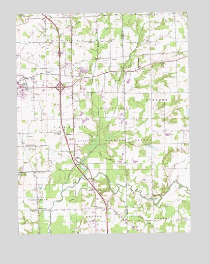
Chestnut Ridge, IN USGS Topographic Map
Click on map above to begin viewing in our Map Viewer.

This topographic map contains these locations and features:
Feature Name Type Latitude Longitude GNIS ID View Map
Banks Hog FarmLocaleN38.9042°W85.8183°2710723View Map
Barkman CemeteryCemeteryN38.9266°W85.7947°430494View Map
Chestnut RidgePopulated PlaceN38.8887°W85.8603°432464View Map
ConologuePopulated PlaceN38.9756°W85.7991°453035View Map
Conologue ChurchChurchN38.9842°W85.8064°432892View Map
Conologue Post OfficePost OfficeN38.9756°W85.7991°453055View Map
Driftwood CemeteryCemeteryN38.9323°W85.8434°433691View Map
Farmington CemeteryCemeteryN38.9303°W85.8681°434408View Map
FlemingPopulated PlaceN38.9737°W85.8064°434582View Map
Gardner CemeteryCemeteryN38.9233°W85.8627°434953View Map
Gum Lick CreekStreamN38.8989°W85.8019°435556View Map
Hunt CemeteryCemeteryN38.9664°W85.7939°436613View Map
John McDonald DitchCanalN38.8789°W85.8336°437020View Map
Kriete CornerPopulated PlaceN38.9176°W85.8328°437459View Map
Lewis BranchStreamN38.8759°W85.8364°437802View Map
Luther McDonald DitchCanalN38.9106°W85.8603°438415View Map
Muscatatuck National Wildlife RefugeParkN38.9375°W85.8103°446733View Map
Mutton CreekStreamN38.9742°W85.8164°439909View Map
Mutton Creek DitchCanalN38.9326°W85.8153°439910View Map
Myers BranchStreamN38.9206°W85.8214°439913View Map
Myers CemeteryCemeteryN38.9053°W85.7839°439914View Map
New FarmingtonPopulated PlaceN38.9251°W85.8669°440046View Map
New Hope ChurchChurchN38.8898°W85.8178°440065View Map
NewryPopulated PlaceN38.9048°W85.8222°452199View Map
Sandy BranchStreamN38.9195°W85.8236°443009View Map
Seymour Fire Department Station 3BuildingN38.9547°W85.8622°2626517View Map
Sixmile CreekStreamN38.9020°W85.7633°443565View Map
Staples FordPopulated PlaceN38.8942°W85.7766°446732View Map
Stewart FieldAirportN38.8880°W85.8254°2677001View Map
Storm CreekStreamN38.9742°W85.7922°444237View Map
Storm Creek DitchCanalN38.9473°W85.8014°444238View Map
Wohrer CemeteryCemeteryN38.9835°W85.7782°446229View Map

Note: Coordinates in the location and feature list above are referenced to NAD83 datum.


Copyright (C) 2008-2025 Ryan Niemi / Sunset Dynamics ... All Rights Reserved