TopoQuest Logo
Do you find TopoQuest useful?
Help keep TopoQuest running and adding new maps/features by donating!
Bitcoin:  19c7KJd3qBynnjoSw5npx9KScwjBe4ifkT
Litecoin:  LXs6TkuXGGXo1vDsWCkWVdjQX94eUKd6ui
Home View Maps Find Maps Find Places Resources & Links


Gold Hill, North Carolina Topographic Map

USGS Map Title: Gold Hill, NC
USGS Map MRC: 35080E3
DRG (GeoTIFF) Download: o35080e3.tif


Neighboring USGS Topographic Map Quads:


  Salisbury, NC  
35080F4
 

  Southmont, NC  
35080F3
 

  Grist Mountain, NC  
35080F2
 

  Rockwell, NC  
35080E4
 

  Gold Hill, NC  
35080E3
 

  High Rock, NC  
35080E2
 

  Mount Pleasant, NC  
35080D4
 

  Richfield, NC  
35080D3
 

  New London, NC  
35080D2


Map MRC Location:

N36°
W81°
N36°
W80°
H8 H7 H6 H5 H4 H3 H2 H1
G8 G7 G6 G5 G4 G3 G2 G1
F8 F7 F6 F5 F4 F3 F2 F1
E8 E7 E6 E5 E4 E3 E2 E1
D8 D7 D6 D5 D4 D3 D2 D1
C8 C7 C6 C5 C4 C3 C2 C1
B8 B7 B6 B5 B4 B3 B2 B1
A8 A7 A6 A5 A4 A3 A2 A1
N35°
W81°
N35°
W80°

Gold Hill, NC USGS 1:24K Topographic Map Preview:
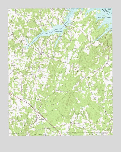
Gold Hill, NC USGS Topographic Map
Click on map above to begin viewing in our Map Viewer.

This topographic map contains these locations and features:
Feature Name Type Latitude Longitude GNIS ID View Map
Allin (historical)Populated PlaceN35.5035°W80.3220°1001797View Map
East Corinth ChurchChurchN35.5568°W80.2817°984491View Map
East Gold Hill Fire DepartmentBuildingN35.5215°W80.3405°2639720View Map
Gold HillPopulated PlaceN35.5213°W80.3381°985767View Map
Gold Hill AirportAirportN35.5090°W80.3112°997932View Map
Gold Hill CemeteryCemeteryN35.5024°W80.3509°985769View Map
Gold Hill ChurchChurchN35.5110°W80.3464°985772View Map
Gold Hill Post OfficePost OfficeN35.5221°W80.3380°2774134View Map
Gold Hill QuarryMineN35.5003°W80.3208°2649039View Map
LibertyPopulated PlaceN35.5813°W80.3356°1021141View Map
Liberty Volunteer Fire Department Station 59BuildingN35.5815°W80.3350°2639444View Map
Liberty Volunteer Fire Department Station 60BuildingN35.6147°W80.3128°2638760View Map
Lonesome FieldAirportN35.5178°W80.2588°2679247View Map
Morgan CemeteryCemeteryN35.5518°W80.2789°990225View Map
Morgan Elementary SchoolSchoolN35.5799°W80.3367°1001879View Map
Panther PointCapeN35.6026°W80.2526°991838View Map
Panther Point CreekStreamN35.6068°W80.2509°991839View Map
Pilgrim ChurchChurchN35.5354°W80.3376°992196View Map
Pool (historical)Populated PlaceN35.5413°W80.3370°1001897View Map
Reedy CreekStreamN35.6010°W80.3112°993187View Map
Saint Matthews ChurchChurchN35.6057°W80.3012°994068View Map
Saint Paul ChurchChurchN35.5118°W80.3003°994073View Map
Saint Peters CemeteryCemeteryN35.5674°W80.3664°994108View Map
Saint Peters ChurchChurchN35.5690°W80.3676°994118View Map
Sand BranchStreamN35.5649°W80.3562°994217View Map
Township of MorganCivilN35.5570°W80.2752°1027148View Map
Union Copper MineMineN35.5039°W80.3547°2649375View Map
Wyatts Grove ChurchChurchN35.5865°W80.2523°997666View Map
Zion ChurchChurchN35.5274°W80.3609°997769View Map

Note: Coordinates in the location and feature list above are referenced to NAD83 datum.


Copyright (C) 2008-2024 Ryan Niemi / Sunset Dynamics ... All Rights Reserved