TopoQuest Logo
Do you find TopoQuest useful?
Help keep TopoQuest running and adding new maps/features by donating!
Bitcoin:  19c7KJd3qBynnjoSw5npx9KScwjBe4ifkT
Litecoin:  LXs6TkuXGGXo1vDsWCkWVdjQX94eUKd6ui
Home View Maps Find Maps Find Places Resources & Links


Hillcrest, Georgia Topographic Map

USGS Map Title: Hillcrest, GA
USGS Map MRC: 33085B1
DRG (GeoTIFF) Download: o33085b1.tif


Neighboring USGS Topographic Map Quads:


  Frolona, GA  
33085C2
 

  Franklin, GA  
33085C1
 

  Newnan SW, GA  
33084C8
 

  Glenn, GA  
33085B2
 

  Hillcrest, GA  
33085B1
 

  Hogansville, GA  
33084B8
 

  Abbottsford, GA  
33085A2
 

  La Grange, GA  
33085A1
 

  Mountville, GA  
33084A8


Map MRC Location:

N34°
W86°
N34°
W85°
H8 H7 H6 H5 H4 H3 H2 H1
G8 G7 G6 G5 G4 G3 G2 G1
F8 F7 F6 F5 F4 F3 F2 F1
E8 E7 E6 E5 E4 E3 E2 E1
D8 D7 D6 D5 D4 D3 D2 D1
C8 C7 C6 C5 C4 C3 C2 C1
B8 B7 B6 B5 B4 B3 B2 B1
A8 A7 A6 A5 A4 A3 A2 A1
N33°
W86°
N33°
W85°

Hillcrest, GA USGS 1:24K Topographic Map Preview:
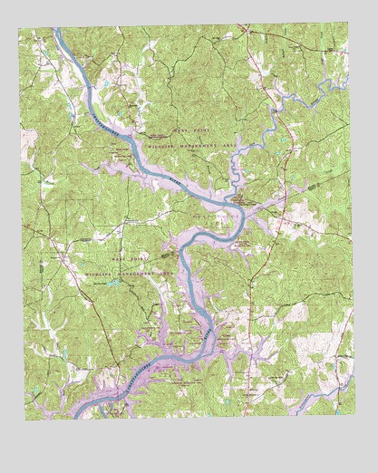
Hillcrest, GA USGS Topographic Map
Click on map above to begin viewing in our Map Viewer.

This topographic map contains these locations and features:
Feature Name Type Latitude Longitude GNIS ID View Map
Brown CrossroadLocaleN33.1876°W85.0263°1673171View Map
Brush CreekStreamN33.2029°W85.0772°354879View Map
Brush Creek Recreation AreaParkN33.2098°W85.0861°347006View Map
Buena VistaPopulated PlaceN33.1418°W85.0919°1673044View Map
Buttrill CemeteryCemeteryN33.2459°W85.1174°347008View Map
Capstan (historical)Populated PlaceN33.2171°W85.0652°347012View Map
Carser ChapelChurchN33.2410°W85.0055°312358View Map
Carser Chapel CemeteryCemeteryN33.2412°W85.0202°355004View Map
Carter Creek Recreational AreaParkN33.1810°W85.0413°1673048View Map
Chattahoochee ParkParkN33.1548°W85.0661°1673050View Map
Clear CreekStreamN33.2318°W85.0088°312718View Map
Cooksville Fire Department Station 8BuildingN33.2433°W85.0192°2604462View Map
Crossroad Recreation AreaParkN33.1348°W85.0633°1673061View Map
Daniels PondReservoirN33.1684°W85.0905°313300View Map
Dowell CemeteryCemeteryN33.2240°W85.0422°347032View Map
Five PointsPopulated PlaceN33.2479°W85.0386°347042View Map
Foster DamDamN33.1451°W85.1099°340182View Map
Foster LakeReservoirN33.1461°W85.1096°340183View Map
Fromby CreekStreamN33.2268°W85.0252°314441View Map
Georgia Recreation AreaParkN33.1271°W85.0911°1673081View Map
Graysons LandingPopulated PlaceN33.1765°W85.0555°1673084View Map
Harbor HospitalHospitalN33.1318°W85.0397°1673086View Map
Harmony School (historical)SchoolN33.2248°W85.0833°347065View Map
Harris CemeteryCemeteryN33.2043°W85.1208°347066View Map
Hillabahatchee CreekStreamN33.2485°W85.1105°120114View Map
HillcrestPopulated PlaceN33.1293°W85.0402°315418View Map
Hillcrest Baptist ChurchChurchN33.1368°W85.0405°1673091View Map
Hillcrest DivisionCivilN33.1410°W85.0363°1936315View Map
Hillcrest Methodist ChurchChurchN33.1312°W85.0408°1673092View Map
Indian BendPopulated PlaceN33.1410°W85.1138°1673100View Map
Moody BridgeBridgeN33.1323°W85.0880°318410View Map
Mooty Ferry (historical)CrossingN33.1315°W85.0897°1673108View Map
Mount Olive ChurchChurchN33.2451°W85.0483°318766View Map
New Harmony CemeteryCemeteryN33.2257°W85.0833°347103View Map
New Harmony ChurchChurchN33.2251°W85.0836°356183View Map
New RiverStreamN33.1932°W85.0472°319523View Map
New River Recreation AreaParkN33.1932°W85.0402°347105View Map
North LakesidePopulated PlaceN33.1351°W85.0097°1673113View Map
Old Harmony CemeteryCemeteryN33.2101°W85.0599°347113View Map
Old Mount Olive CemeteryCemeteryN33.2484°W85.0374°347114View Map
Old Philpot FerryLocaleN33.1923°W85.0430°320009View Map
Old Shiloh CemeteryCemeteryN33.1857°W85.0213°1673115View Map
Owensby CemeteryCemeteryN33.2129°W85.0899°347119View Map
OwensbyvillePopulated PlaceN33.1873°W85.0861°326445View Map
Philpot CemeteryCemeteryN33.1954°W85.0427°347121View Map
Point NorthPopulated PlaceN33.1893°W85.0277°1673118View Map
Potato CreekStreamN33.1885°W85.0402°321091View Map
Purgason CemeteryCemeteryN33.2093°W85.0216°347126View Map
Rains CemeteryCemeteryN33.2429°W85.0519°347127View Map
Redbud CreekStreamN33.2340°W85.0299°321411View Map
Ringer Recreation AreaParkN33.1507°W85.0483°1673121View Map
Rocky Mount ChurchChurchN33.1371°W85.0269°321856View Map
Shiloh ChurchChurchN33.1860°W85.0216°322879View Map
Snake Creek Recreation AreaParkN33.2146°W85.0791°347145View Map
Swanson IslandIslandN33.1482°W85.0547°323804View Map
Talley BranchStreamN33.1943°W85.0536°323894View Map
Troup County Fire Department Station 2BuildingN33.1293°W85.0395°2604949View Map
Western Baptist ChurchChurchN33.1771°W85.1094°325085View Map
Zachry CreekStreamN33.2146°W85.0824°325653View Map

Note: Coordinates in the location and feature list above are referenced to NAD83 datum.


Copyright (C) 2008-2024 Ryan Niemi / Sunset Dynamics ... All Rights Reserved