TopoQuest Logo
Do you find TopoQuest useful?
Help keep TopoQuest running and adding new maps/features by donating!
Bitcoin:  19c7KJd3qBynnjoSw5npx9KScwjBe4ifkT
Litecoin:  LXs6TkuXGGXo1vDsWCkWVdjQX94eUKd6ui
Home View Maps Find Maps Find Places Resources & Links


Holiday Lake, Virginia Topographic Map

USGS Map Title: Holiday Lake, VA
USGS Map MRC: 37078D6
DRG (GeoTIFF) Download: o37078d6.tif


Neighboring USGS Topographic Map Quads:


  Gladstone, VA  
37078E7
 

  Saint Joy, VA  
37078E6
 

  Buckingham, VA  
37078E5
 

  Vera, VA  
37078D7
 

  Holiday Lake, VA  
37078D6
 

  Andersonville, VA  
37078D5
 

  Appomattox, VA  
37078C7
 

  Pamplin, VA  
37078C6
 

  Prospect, VA  
37078C5


Map MRC Location:

N38°
W79°
N38°
W78°
H8 H7 H6 H5 H4 H3 H2 H1
G8 G7 G6 G5 G4 G3 G2 G1
F8 F7 F6 F5 F4 F3 F2 F1
E8 E7 E6 E5 E4 E3 E2 E1
D8 D7 D6 D5 D4 D3 D2 D1
C8 C7 C6 C5 C4 C3 C2 C1
B8 B7 B6 B5 B4 B3 B2 B1
A8 A7 A6 A5 A4 A3 A2 A1
N37°
W79°
N37°
W78°

Holiday Lake, VA USGS 1:24K Topographic Map Preview:
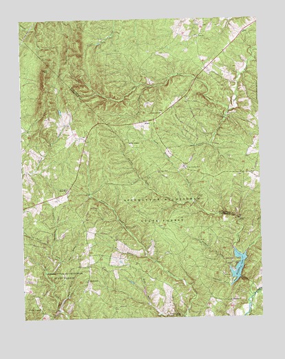
Holiday Lake, VA USGS Topographic Map
Click on map above to begin viewing in our Map Viewer.

This topographic map contains these locations and features:
Feature Name Type Latitude Longitude GNIS ID View Map
Appomattox Buckingham State ForestParkN37.3935°W78.7292°1462529View Map
Bear BranchStreamN37.4007°W78.6853°1462873View Map
Bethlehem ChurchChurchN37.3821°W78.6411°1463236View Map
Cemetery CreekStreamN37.3885°W78.6403°1464662View Map
Forbes (historical)Populated PlaceN37.4354°W78.6353°1690047View Map
Forbes CreekStreamN37.4021°W78.6333°1466753View Map
Fore StorePopulated PlaceN37.4021°W78.6733°1497258View Map
Four H ClubLocaleN37.3907°W78.6397°1493846View Map
Gunner MountainSummitN37.4899°W78.7189°1467607View Map
Hog BranchStreamN37.3988°W78.7306°1468096View Map
Holiday CreekStreamN37.3846°W78.6289°1468129View Map
Holiday DamDamN37.3915°W78.6356°1489165View Map
Holiday LakeReservoirN37.3965°W78.6372°1502192View Map
Holiday Lake Lookout Tower (historical)LocaleN37.4379°W78.6642°1501542View Map
Holiday Lake State ParkParkN37.4001°W78.6417°1497259View Map
Holiday Lake State Recreation AreaParkN37.3979°W78.6406°1468130View Map
HollywoodPopulated PlaceN37.3904°W78.7156°1495707View Map
Jamison CreekStreamN37.4582°W78.6431°1468639View Map
Kyles MountainSummitN37.4790°W78.7353°1469084View Map
Long BranchStreamN37.4724°W78.6822°1469778View Map
Mann CemeteryCemeteryN37.4762°W78.6870°1501556View Map
North Fork Wolf CreekStreamN37.3946°W78.7386°1471623View Map
North Holiday CreekStreamN37.4238°W78.6603°1471625View Map
Pleasant Grove ChurchChurchN37.4610°W78.6758°1472482View Map
Ragby BranchStreamN37.3796°W78.7317°1472931View Map
Rose BowerLocaleN37.4279°W78.7264°1473529View Map
Sanders CreekStreamN37.3957°W78.6408°1474001View Map
SlidersPopulated PlaceN37.4571°W78.6847°1477763View Map
Stillhouse CreekStreamN37.4060°W78.7345°1475143View Map
TogaPopulated PlaceN37.4940°W78.6333°1477816View Map
Toga Airport (historical)AirportN37.4504°W78.6786°1498608View Map
Toga Volunteer Fire DepartmentBuildingN37.4615°W78.6744°2086358View Map
Union ChurchChurchN37.4929°W78.6561°1476052View Map
Webb Mill CreekStreamN37.3760°W78.6661°1476425View Map

Note: Coordinates in the location and feature list above are referenced to NAD83 datum.


Copyright (C) 2008-2024 Ryan Niemi / Sunset Dynamics ... All Rights Reserved