TopoQuest Logo
Do you find TopoQuest useful?
Help keep TopoQuest running and adding new maps/features by donating!
Bitcoin:  19c7KJd3qBynnjoSw5npx9KScwjBe4ifkT
Litecoin:  LXs6TkuXGGXo1vDsWCkWVdjQX94eUKd6ui
Home View Maps Find Maps Find Places Resources & Links


Holy Cross, Iowa Topographic Map

USGS Map Title: Holy Cross, IA
USGS Map MRC: 42090E8
DRG (GeoTIFF) Download: o42090e8.tif


Neighboring USGS Topographic Map Quads:


  Turkey River, IA  
42091F1
 

  Cassville, WI  
42090F8
 

  Balltown, IA  
42090F7
 

  New Vienna, IA  
42091E1
 

  Holy Cross, IA  
42090E8
 

  Sherrill, IA  
42090E7
 

  Dyersville East, IA  
42091D1
 

  Epworth, IA  
42090D8
 

  Peosta, IA  
42090D7


Map MRC Location:

N43°
W91°
N43°
W90°
H8 H7 H6 H5 H4 H3 H2 H1
G8 G7 G6 G5 G4 G3 G2 G1
F8 F7 F6 F5 F4 F3 F2 F1
E8 E7 E6 E5 E4 E3 E2 E1
D8 D7 D6 D5 D4 D3 D2 D1
C8 C7 C6 C5 C4 C3 C2 C1
B8 B7 B6 B5 B4 B3 B2 B1
A8 A7 A6 A5 A4 A3 A2 A1
N42°
W91°
N42°
W90°

Holy Cross, IA USGS 1:24K Topographic Map Preview:
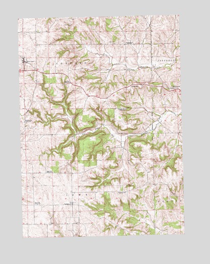
Holy Cross, IA USGS Topographic Map
Click on map above to begin viewing in our Map Viewer.

This topographic map contains these locations and features:
Feature Name Type Latitude Longitude GNIS ID View Map
BankstonPopulated PlaceN42.5186°W90.9612°454346View Map
Bankston Park Cemetery (historical)CemeteryN42.5597°W90.9474°2001487View Map
Bankston Post Office (historical)Post OfficeN42.5186°W90.9612°2001407View Map
Bankston SchoolSchoolN42.5250°W90.9193°454347View Map
Christian CemeteryCemeteryN42.5806°W90.9085°2001489View Map
City of BankstonCivilN42.5076°W90.9613°2394059View Map
City of Holy CrossCivilN42.6011°W90.9962°2394410View Map
City of RickardsvilleCivilN42.5815°W90.8762°2396372View Map
Cottage HillPopulated PlaceN42.5853°W90.9137°455653View Map
Cottage Hill Christian CemeteryCemeteryN42.5837°W90.9177°2001491View Map
Cottage Hill Post Office (historical)Post OfficeN42.5853°W90.9137°2001406View Map
Cottage Hill Protestant CemeteryCemeteryN42.5862°W90.9126°2001490View Map
Cottage Hill SchoolLocaleN42.5722°W90.9168°455654View Map
Eagle SchoolLocaleN42.5372°W90.9757°456102View Map
Flanagan SchoolLocaleN42.6094°W90.9168°456627View Map
Floyd CemeteryCemeteryN42.5972°W90.9807°2001492View Map
Floyd SchoolSchoolN42.5878°W90.9604°465641View Map
Harvestore Grain ElevatorLocaleN42.5972°W90.9904°2001324View Map
Holy CrossPopulated PlaceN42.6006°W90.9957°457572View Map
Holy Cross - North Buena Vista Fire DepartmentBuildingN42.6011°W90.9963°2577239View Map
Holy Cross Catholic CemeteryCemeteryN42.6017°W90.9976°2001493View Map
Holy Cross ChurchChurchN42.6011°W90.9971°2001329View Map
Holy Cross City HallBuildingN42.6019°W90.9960°2001325View Map
Holy Cross LibraryBuildingN42.6019°W90.9960°2001326View Map
Holy Cross Post Office (historical)Post OfficeN42.6014°W90.9949°2001354View Map
La Salle Catholic School - Holy Cross CenterSchoolN42.6003°W90.9971°2001327View Map
O'NeillPopulated PlaceN42.6089°W90.8868°465362View Map
O'Neill Post Office (historical)Post OfficeN42.6089°W90.8868°2001403View Map
Pershing SchoolLocaleN42.5664°W90.9965°460094View Map
Richardsville Methodist CemeteryCemeteryN42.5835°W90.8817°2001488View Map
RickardsvillePopulated PlaceN42.5833°W90.8840°460625View Map
Rickardsville Post Office (historical)Post OfficeN42.5833°W90.8840°2001404View Map
Saint Clement Catholic CemeteryCemeteryN42.5196°W90.9618°2001486View Map
South Lane FarmLocaleN42.5081°W90.9600°2708593View Map
Tivoli CemeteryCemeteryN42.5194°W90.9918°2001454View Map
Tivoli Post Office (historical)Post OfficeN42.5189°W90.9907°2001405View Map
Tivoli School (historical)SchoolN42.5189°W90.9882°462265View Map
Township of ConcordCivilN42.6022°W90.9563°467646View Map
Township of IowaCivilN42.5147°W90.9567°468080View Map

Note: Coordinates in the location and feature list above are referenced to NAD83 datum.


Copyright (C) 2008-2024 Ryan Niemi / Sunset Dynamics ... All Rights Reserved